This is a specific subject
page, dealing exclusively with, or primarily with, the subject in the
title. Because of need, there are many such pages at RHWW: usually, but
not always, linked to primary pages. For those in a hurry, they enable
a quick summary of many important subjects. The menu for these pages is
here: Click>>>
American Indian Phenotypes
In genetics, the phenotype is
the set of observable characteristics or traits of an organism. The
term covers the organism's morphology (physical form and structure),
its developmental processes, its biochemical and physiological
properties, its behavior, and the products of behavior. An organism's
phenotype results from two basic factors: the expression of an
organism's genetic code (its genotype) and the influence of
environmental factors. Both factors may interact, further affecting the
phenotype.
|
For well over a hundred years now, Americas
Albinos have cultivated a scenario wherein the indigenous people of the
Americas were some BROWN Skinned, Caucasian or Mongol looking people
who also
bought African Slaves or at the very least ACCEPTED “Runaway” Slaves
into their Tribes. And all Negroid Blacks in the Hemisphere are derived
from African Slaves. The falsity of that Albino Fantasy tale is
demonstrated
in our Original Paper “Indigenous Peoples”. This is the addendum to
that page called “Indian Phenotypes”. Rather than presenting data and
written sources to deconstruct those Albino lies and nonsense, here we
simply play “Show and Tell”.
Right-away lets address the implication of the Indian tribes map
below, that being that Indians - American and Asian - are naturally
some sort of "Red Skinned" or Brown Skinned people. That is pure Albino
fabrication. Natural Healthy Humans only come ONE way as far as skin
color goes - that is BLACK! Brown and Yellow complexions came about because of
admixture with WHITE SKINNED Blacks who have the disease of Albinism. Thus, the concept of Red Skin is the
result of Albinism, Albino fantasy, or Albino ill health. Right now we
are concerned with the Albino habit of calling Black American Indians
("Red-Men"). Of course one reason is that it's just so they don't have to acknowledge
the Indians Blackness, being White Skinned has made the Albinos very
sensitive about skin color.
Caution - Caution - Caution
By-the-way, we must caution you that if you
actually click the link and read Professor Dunbar-Ortiz essay, you will
then be officially "WOKE". And as such, you will no longer be welcomed
in the state of Florida by order of the governor of Florida Ronald
DeSantis. The governor does not want anyone telling "True History" in Florida, that would mean Albino
Children learning about the terrible things their Parents, Grandparents, Great
grandparents, Great, great, grandparents etc, etc. did to other human
beings purely for the sake of conquest and unbridled greed. As the
governor has said many times "Florida is where "WOKE" goes to die".
Note: Woke is an adjective derived from African-American Vernacular
English meaning "alert to racial prejudice and discrimination".
|
Does DeSantis aggressive racism seem
out of place
to you? In the recent past these kind of Albinos tried to hide their
racism. But since Trump they have grown ever more aggressive in spewing
their venom. Funny thing, though Trump is their catalyst, and they
worship him, he is not really one of them. Donald Trump is a selfish,
talentless, useless, pampered, son of a modestly Rich New York Man. The only
skill he ever developed was "Grifting", he would, and did, cheat
everybody. Though useless, he was nonetheless smart enough to see that
if he said the right hate things against the right people, he could
build an army of degenerate lunatic Albinos who would follow him
through hell and high water. Ronald DeSantis, governor of Florida, is
now trying the same thing.
What is the meaning of Breed? In biology: a group of animals or plants
presumably related by descent from common ancestors and visibly similar
in “most” characters but NOT all. Compare characters of Pit Bull
Terriers and Poodles – one of the most intelligent dog breeds.
What is the meaning of “Creed”. The answer - a set of beliefs or aims
which guide someone's actions. The term is usually restricted to
declarations within the Christian faith and is especially associated
with churches of the Protestant Reformation. Ah yes Protestants: Most
Blacks in the U.S. are Protestants, not by choice, but simply because
the Conquered or Enslaved has no choice but to accept and practice the
religion of the Master. To their credit Black Americans have made
changes to Protestantism which makes it their own. Apparently not so
with Catholicism, it seems Spanish speaking Blacks, and especially
Mulattoes, accepted the religion of the Spanish and Portuguese in
totality.
Ever wonder why Albino evangelicals (Protestants - supposedly the
“Good” people) sanctioned the killing of Abortion Doctors when
abortion wasn't even initially something they cared about? It was
originally a CATHOLIC issue, but when evangelical preachers saw that it
could be a used to gain power, all of a sudden evangelicals became the
leaders of the antiabortion movement.
Have you ever heard of them supporting women they forced to give birth?
They routinely lie about whatever will give them advantage. Their
supreme court justices lied while being questioned for confirmation;
Chief Justice Roberts repeatedly declined to comment on Roe beyond
saying he believed it was "settled as a precedent of the court."
Meaning that it was PERMANANT LAW! Those who voted to strike down “Roe”
said similar things. The majority opinion, authored by Justice Samuel
Alito, was joined by Justices Clarence Thomas, Neil Gorsuch, Brett
Kavanaugh, and Amy Coney Barrett.
As is clear, these people have no creed; they don't believe in
“Freedom” except for themselves, they don't believe in “Democracy” as
evidenced by their love of Putin and Trump, and they certainly don't
believe in “Truth and Justice” as evidenced by all their lies and the
things they try to do to deny justice to everybody else. To those who
wonder what is going on - it all makes sense if you know who they
really are – what is their “Breed”.
These are the “Same” people (genetically- their Breed) who sacrificed
258,000 of their soldiers to keep Blacks - Indians and Africans –
enslaved. They are also the same people who tricked some of their
former Black leaders in Europe into supporting them, and the new
religion they had just created “Protestantism” against the “Holy Roman
Empire” and the standard Black religion of Catholicism in the “Thirty
Years War” (1618 to 1648). The result of that War was an Albino win and
the eventual taking of power World-Wide by Albinos.
We don't know why this breed of Albinos are so
hateful and violent, we thought that they just hated Blacks, or because
they feared the given the chance, Blacks would take revenge for what
happened in Europe. But the thing is that if there are no Blacks
around, they will turn their hate onto the Spicks, and if there are no
Spicks around, they will turn their hate onto the Chinks. But all the
while, if you pay close attention, what they really want is to be away
from the Niggers, Spicks, and Chinks. And there we see what is really
bothering this breed of Albinos; they fear that they cannot compete on
level ground with the Niggers, Spicks and Chinks, so they make war on
them in the hopes of defeating them and driving them away, like they
did in Europe with Blacks.
Joy Reid and Sherrilyn Ifill discuss this new bold "Activism" of this particular Breed of Albinos.
MSNBC anchor Joy Reid interviews Sherrilyn Ifill who is an American lawyer and the Vernon E. Jordan, Jr., Esq.
Endowed Chair in Civil Rights at Howard University. She is a law professor and former president and director-counsel
of the NAACP Legal Defense Fund. She was the Legal Defense Fund's
seventh president since Thurgood Marshall founded the organization in
1940.

|

|

|
The
Protestant Reformation was a religious reform movement that swept
through Europe in the 1500s. After the race and religion wars that
began in 1618, it resulted in the creation of a branch of Christianity
called Protestantism, a name used collectively to refer to the many
religious groups that separated from the Roman Catholic Church as a
result of the wars.
A majority of Protestants
are members of a handful of Protestant denominational families;
Adventists, Anabaptists, Anglicans, Episcopalians, Baptists, Calvinist,
Reformed, Lutherans, Methodists, Moravians, Plymouth Brethren,
Presbyterians, and Quakers. Nondenominational, charismatic and
independent churches constitute a significant part of Protestantism.
Under the heading:
“Never take an Albinos word as truth – ever. These are small things but
telling: How ridicules and sad is it that the U.S. Greatest Civil
Rights leader and Baptist Minister, was named after a Catholic priest and one of the founding architects of the Usurpation
of Black power in Europe, and the Enslavement and Indenture of millions
of Black Europeans in the Americas – Martin Luther.
|
 |

|
Muhammad Ali was an American professional boxer and activist. Nicknamed
"The Greatest", he is regarded as one of the most significant sports
figures of the 20th century and is often regarded as the greatest
heavyweight boxer of all time.
No doubt Turk Albinos suggested this name to Cassius. They understood
that he was desperate to throw off all trappings of the Albinos. Not
wanting to go the "X" way of Malcolm, he decided on a Muslim name, not
understanding that for several hundred years Turks - not Arabs - were
the masters of Islam, and had stained it well with their sins. No way
he understood who this Muhammad Ali was as an individual.
Perhaps it would have been cruel to mention this while he was alive, but he ALREADY had a Black name!
Cassius Marcellus is a ROMAN name, Romans were BLACK people. Just like
the original people EVERYWHERE were Black people. He, like most of you,
believed the Albinos when they told you that they were original
Europeans.
|
As we continue down this page you will be introduced to old pictures of
American Indians.
These "REAL" Indians don't look anything like what
Albino media has "Programmed" you to believe that American Indians
looked like.
Rather, what we see today is Albinos faking as Indians,
and their "One Drop of Indian Blood" Mulattoes lending them
credibility.
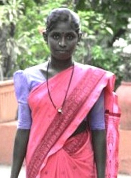
Below we itemize the various types of American Indians,
but
right now we are only concerned with the Black Skinned Dravidian type
Indian.
This
is a route map of the first Humans as they
left Africa to populate the rest of the World. Note that their first
movement was to cross the Southern Arabian Peninsula and enter India.
This new analysis places that time at 90 - 120,000 years ago. The
latest research places Humans entering the Western Hemisphere (the
Americas) at 120 - 150,000 years ago.
|

|
The "Out of Africa" model of early human
migration and dispersal is outdated. As a new survey of research on the
subject confirms, humans left Africa in waves, not in a single exodus.
In the new survey, published this week in the journal Science,
researchers at the Max Planck Institute for the Science of Human
History in Germany and the University of Hawai'i at Manoa detail early
human evolution revelations reported from Asia over the last decade.
|
Many of those first Humans to enter India were Black Skinned Caucasoids we call Dravidians;
they look like this.
These Indian photographs - Asian and American - are in Black and White
because “Color” photography, first tried in the 1860-70s, was not
viable, until, albeit in a limited way, the Autochrome Lumière process
in 1907. There were many other tries at color photography, but none
were commercially successful. Beginning in the 1960s, Kodak's
Kodachrome, along with other film brands, had begun to establish a
presence in the market, but they were still much more expensive than
standard black and white film. By the 1970s, prices were down enough to
make color photography accessible to the masses.
|
|
|
You will notice that some "REAL" American Indians look just like these Asian Indians,
which is of course natural since they are all Africans. But it is a
bother in our understanding of history; whereas Dravidians and the Mongol phenotype Humans left
"EAST" Africa, American Indians, some with the same phenotype, left "WEST" Africa.
Accompanying the Black Dravidians was their Albinos, who if for no
other reason, left Africa to escape the Heat and Strong Sunshine. This is what the Sun will do to Albinos.

|
|

|
So finding that India was just as bad as Africa for their White Skin,
the Albinos headed North across the Hindu Kush mountain range and
entered Central Asia. There they stayed for, (we have no clue as to how
long). But owing to there being none but other Albinos to "Mate" with,
when they left Central Asia at circa 1,500 B.C. the Albinos were now a
"RACE" onto themselves. Their first stop was India where the Albinos
made War on their Creators - the Dravidians. They managed to push the Dravidians into
South India, and instituted policies of Racial subjection and
discrimination. Today World Travelers, including Albinos, denounce
India as the most Racist country in the World.

|
This sort of thing really Pisses India's Albinos off.
|
Origins and Histories of Certain U.S. Indian Tribes
But first a clarification of exactly Who and What these so-called
"Indians" are or were. Quite simply they are/were Black Skinned Humans
of Negroid, Caucasoid, and Mongoloid phenotypes.
|
Definitions from The American Heritage® Dictionary of the English Language, 5th Edition.
Mongoloid:
adjective Of or being a human racial classification traditionally
distinguished by physical characteristics such as Yellowish-Brown skin,
straight black hair, dark eyes with epicanthic folds, and prominent
cheekbones and including peoples indigenous to central and eastern
Asia. No longer in scientific use.
Caucasian:
:adjective Of or relating to a racial group having light-colored skin;
white. adjective Of or being a human racial classification
distinguished
especially by very light to brown skin and straight to wavy or curly
hair, and including peoples indigenous to Europe, northern Africa,
western
Asia, and parts of South Asia. No longer in scientific use. adjective
Of or relating to the Caucasus region or its peoples, languages, or
cultures. adjective Of or relating to a group of three language
families spoken
in the region of the Caucasus mountains, including Chechen, Abkhaz, and
the Kartvelian languages. noun A person having light-colored skin; a
white person. noun A member of the Caucasian racial classification. No
longer in scientific use. noun A native or inhabitant of the Caucasus.
Negroid:
physical characteristics such as brown to black skin and often tightly
curled hair and including peoples indigenous to sub-Saharan Africa. No
longer in scientific use. from The Century Dictionary. noun An
individual of a negroid race, such as those of Micronesia, the Negritos
of the Philippine Islands, and the mixed tribes of northeastern Africa.
Resembling or akin to the Negroes. Also Negroid. from the GNU version
of the Collaborative International Dictionary of
English. noun A member of any one of several East African tribes whose
physical characters show an admixture with other races. adjective
Characteristic of the negro. adjective Resembling the negro or Negroes;
of or pertaining to those who resemble the negro. from WordNet 3.0
Copyright 2006 by Princeton University. All rights
reserved. noun a person with dark skin who comes from Africa (or whose
ancestors came from Africa) adjective characteristic of people
traditionally classified as the Negro race.
|
Oxford University Press
How Did East Asians Become Yellow?
Abstract
This chapter offers a brief historical
intervention explaining the rise of the term yellow for racial thinking
about Asians. Using his binomial nomenclature species-naming system,
the Swedish taxonomist Carolus Linnaeus separated Homo sapiens into
four continental types, with distinct colors assigned to each. Over two
decades later the German anatomist Johann Friedrich Blumenbach also
classified Asians as yellow in his five-race scheme. Although some
early twentieth-century anthropologists claimed to have proven that
Mongolians (Asians) were physically yellow in an attempt to place
Asians lower than Europeans, the initial categorization of yellow had
no visual or biological basis. As Asians continued to refuse to take
part in Western systems (Christianity, international trade), Europeans'
perceptions of Asians' skin color darkened. Moreover in the late
eighteenth and early nineteenth century, the yellow idea began to
spread to East Asian cultures themselves.

Korean
|
|

Chinese
|
CAN ALBINOS EVER “NOT” LIE???
Yellow hued skin is a NATURAL reality for some non-Albino, non-Black Humans.
It generally comes about when Mulattoes produce offspring with other Mulattoes.
As would have happened in North Asia as the supply of pure Blacks dwindled.
Piss colored Nigger or “High Yella” are affectionate slang terms Blacks use to referrer to yellow Hued Mulattoes.
The song “Yellow Rose of Texas” was written by a young Black Man yearning to see his Mulatto
girlfriend again. Albinos have of course changed the lyrics, so you will need to research the original lyrics.
The Albino submissions above are pure Nonsense of course,
but instructive as you watch Albinos explain their existence,
then watch as they try to explain the existence of their "Creators - Us."
As we say, Black Women make White people on a DAILY basis.

|
This Grandmother and Granddaughter are NOT Chinese, they are the San of the Kalahari Desert and south east Africa. They and other Mongol Phenotype Africans, mixed with Albinos, are the progenitors of modern Chinese.
CNN-2017: Caught between modernity and 20,000 years as
hunter-gatherers, the San people sit at a crossroads. An indigenous
people in southern Africa, they are our oldest human ancestors,
DNA testing proving the San are direct descendants of the first Homo
sapiens. But today their culture, traditions and heritage are at risk
of being lost forever.
|
Quote from above: They and other Mongol Phenotype Africans, mixed with Albinos, are the progenitors of modern Chinese.
|
|
Modern Chinese Albino - Note; straight hair is "Recessive" "Nappy" hair is "Normal" in Humans. Albinism often, but not always, straightens hair.
|

|
|

|
Just as Caucasian phenotype Albinos do all they can to hide their Black
origins, so too do the Mongol phenotype Mulattoes. Obviously
the typical Chinese, Japanese, Korean, etc. does not look like the
young Chinese Albino above, that is because they are Mulattoes NOT
Albinos, they are the "Product" of the Black settlers of north Asia (the Jomon and Ainu) and their Albinos.
This old man and his granddaughter show you how it all works.
But we have something better!

Notice that Kublai Khan is "Pale" but his wife is a "Pure" Albino.
Those Chinese Albinos admixing with the original Black Chinese (like the horseman) produced todays "Yellow" Chinese.
|
|
 |
The Chinese like all Mulatto people, jealously guard their closeness to White; they view themselves as weak,
therefore the closer they get to the people with power (Albinos), the more powerful they become.
In the modern era;
when scientists told the Chinese that they came from Africa,
they were mortified, they were outraged. Immediately Chinese
scientists tried to find an alternative evolution for Chinese people.
In 1923–27 during excavations at Zhoukoudian China, near Beijing (formerly "Peking")
bones were found from a ~750,000 year old Humanoid dubbed "Peking Man". Many people,
including some Chinese, claimed that the Chinese people descended from this Peking Man;
who in fact was actually a Homo-Erectus.
In response, in 2001, many of the worlds leading genetic researchers produced a study
which clearly showed that the Chinese, like everyone else, descended from Africans.
For those of you who do not believe the above statement;
Here is the Scientific proof to support that statement.

|
 |
CNN-2016:
A new genomic study has revealed that Aboriginal Australians are the
oldest known civilization on Earth, with ancestries stretching back
roughly 75,000 years. In a study published in the journal Nature
Wednesday, a group of international researchers – including nine
Aboriginal leaders – collected genomic data on 83 Aboriginal
Australians and 25 Highland Papuans from Papua New Guinea. The findings
indicated their ancestors had diverged from Eurasians 57,000 years ago,
following a single exodus from Africa around 75,000 years ago.
|
That "Twang" and the offer of a Shrimp on the Barbi
doesn't sound so charming anymore - does it?
Just standard Albino "Modus Operandi",
that being Racial Atrocities! It must be hard being an Albino.
The same things happened in Europe and the Americas.
The Dravidian Albinos (White Europeans) are
native to Central Asia via Africa and then India.
The Beginning...
Africans first settled the Americas 130-150,000 years ago.
Here is the science to support that statement.
WE HAVE A NEW PAGE EXPLAINING THE TREK OF THOSE
ANCIENT AFRICANS TO REACH THE AMERICAS 150,000 YEARS AGO.
< Click here to learn how ancient Africans reached the Americas >
Among those founding Africans were Africans of every type,
the only thing they all had in common was "Black Skin".
Here is the science to explain the above.
Here is the science to support that there was TWO migrations to the Americas.
Note; Clovis associated genome means the Black Mongol type
Africans who first crossed over to Asia circa 60,000 B.C,
and then crossed over to the Americas by way
of the Bering Straits at circa 12,000 B.C.
This is what those Early Africans looked like.
We don't know what color variation there was in these early Africans
because we don't know when the first Albinos were produced by ancient Africans,
as Albinos have the effect of lightening Black Skin by admixture.
A good example of the Black Skinned Mongol
American Indian is the Tlingit of Alaska.

|
Good examples of Dravidian phenotype Black Skinned
Caucasoid Indians are the Apache and the Sioux.
These two Black Skinned Dravidian type Indians are of unknown tribes.
HOWEVER - THERE WAS SOME "CROSSOVER".
Note: Mongols are found all over the Americas,
however few Pure-Blood Mongols remain today,
just about all show Albino admixture in color and features.
Black Skinned Negroid phenotype Americans (nappy to curly hair, broad nose-bridge)
are by far the most numerous Humans in the world and Americans. They are found mostly in the Eastern and
Western United States (the Coasts), plus Central and South America and all over Asia and Oceania.
Oceania is the collective name for the islands scattered throughout most of the Pacific Ocean.
The term, in its widest sense, embraces the entire insular region between Asia and the Americas.
A more common definition excludes the Ryukyu, Kuril, and Aleutian islands and the Japan archipelago.
Canada, North-East, North-Central, U.S.A.
The Algonquians (or Algonkians) are a group of Native American tribes
that traditionally spoke similar languages and had similar ways of life.
The Cree, the Mohican, the Delaware (Lenni Lenape), the Ojibwa, the
Shawnee, and the Algonquin are a few of the many Algonquian tribes.
The Lenni-Lenape
The
“grandfathers” or “ancient ones” as the Lenni-Lenape people are known,
were the historic inhabitants of large swaths of the Northeastern
United States. Originally occupying parts of New York, New Jersey,
Delaware, and Pennsylvania, the Lenape suffered forced migrations and
removal to reservations at the hands of European settlers. In fact,
prior to the 1600s, the Lenape lived all over the Northeastern
woodlands and the Eastern Shore of Maryland, as noted on
nanticokelenapemuseum.org. The Lenape trace their lineage to the
Nanticoke or “Tidewater People” who resisted British colonial intrusion
to the best of their abilities. The name “Nanticoke” references the
Nanticoke River on the Eastern Shore of Maryland.
At the time of European contact in the early
1600s, the Lenape were estimated to number over 20,000 people. A
powerful and influential tribe, early Dutch settlers sought to
establish amicable relations with the Lenape through trade of tools,
sugar, firearms, animal pelts, and fabric. Unfortunately, like most
early contact between Native Americans and European immigrants,
tribespeople were deceived and diminished by unfair trade agreements
and the introduction of contagious diseases.

|
Dutch traders were
established on the banks of the Delaware River by 1623. Swedish and
Finnish colonists followed, significantly predating the arrival of
German and English travelers in response to the establishment of
William Penn’s colony. Familiar with the forests of Northern Europe,
the Nordic immigrants cleared woodland in the new territory and
introduced the use of the log cabin. What little is known of these
early encounters between the Swedes and the Lenape is that both groups
were independent, rugged individualists who practiced similar
agricultural methods, rotating productive fields of crops along the
banks of the Delaware River, according to paheritage.wpengine.com. In
contrast, the Dutch were eager to establish business in the New World.
They engaged in the trade of land, guns, and beads for beaver pelts.
One of the most notorious transactions between the Dutch and the Lenape
was the “purchase” of New York City in 1626.
Long before high rise
buildings and endless concrete sidewalks, New York City was truly an
idyllic island, scattered with hills and marshland and teeming with
plant and wildlife. Oak and hickory forests dotted the landscape while
black bears, wildcats, beavers, tree frogs, oysters, mink, brook trout,
and bog turtles roamed free. In a 2020 New York Times article,
ecologist Eric W. Sanderson of the Wildlife Conservation Society, based
at the Bronx Zoo, noted that wolves were known to live on Manhattan
until the 1720s and whales were an important part of the local
ecosystem.
“Mannahatta” (as it was
referred to in the Lenape language) was a trading hub for the Lenape
bands of tribes who regularly gathered on the island for the exchange
of goods. Mannahatta was also the site of Lenape games and musical
performances. The native dwellers certainly made use of the plethora of
natural resources at their disposal. For example, soaring tulip trees
were favored for making canoes and the rich soil and pond water was
ideal for cultivating vegetables and oyster estuaries.

|
|

|
In his poem “Mannahatta,” fabled New York resident Walt Whitman writes:
“I was asking for something specific and perfect for my city,
Whereupon lo! upsprang the aboriginal name.
Now I see what there is in a name, a word, liquid, sane, unruly,
musical, self-sufficient, I see that the word of my city is that word
from of old, Because I see that word nested in nests of water-bays,
superb, Rich, hemm’d thick all around with sailships and steamships, an
island sixteen miles long, solid-founded….”
While Whitman paid literary homage to the original inhabitants of
Manhattan, the actual transaction that took place between the Dutch and
Lenape in 1626 was less equitable.
Many modern-day historians suspect that the Lenape intended the sale to
be for the purposes of sharing the island rather than excluding
themselves from it.
Two monuments in Manhattan currently stand in acknowledgement of the
Lenape. One is in Inwood Hill. The plaque reads, “According to legend,
on this site of the principal Manhattan Indian village, Peter Minuit in
1626 purchased Manhattan island for trinkets and beads then worth about
60 guilders.”
The other monument, in Battery Park, was gifted by the Dutch government
to the state of New York in 1926. It depicts a Dutch man and Native
American standing together. Scholars have criticized the monument for
its inaccurate depiction of Lenape dress (the Native American figure is
outfitted in Plains Indian garments).
According to thelenapecenter.com, the purchase of the island of
Manhattan by the Dutch was quickly reinforced through the construction
of a wall around New Amsterdam. This act represented the first time
that the Lenape were forced out of their lands at the hands of European
immigrants. The wall was constructed in 1660 around what is today known
as Wall Street. The passage between Lower Manhattan and Upper Manhattan was a major trade route and cultural hub for the Lenape people.
|
|

|

|

|

|

|
Apparently the Delaware (Lenni Lenape)
Indians precipitated the Albino phrase "RedSkin".
The Albinos teach that it was Indians who did the SCALPING, but they
don't tell you that it was THEM who taught it to the Indians, and the
Indians were only returning the FAVOR! Scalping had been known in
Europe, according to accounts, as far back as ancient Greece. More
often, though, the European manner of execution involved beheading.
Enemies captured in battle - or people accused of political crimes -
might have their heads chopped off by victorious warriors or civil
authorities.
In some places and times in European history, leaders in power offered
to pay "bounties" (cash payments) to put down popular uprisings. In
Ireland, for instance, the occupying English once paid bounties for the
heads of their enemies brought to them. Europeans brought this cruel
custom of paying for killings to the American frontier. Here they were
willing to pay for just the scalp, instead of the whole head. The first
documented instance in the American colonies of paying bounties for
native scalps is credited to Governor Kieft of New Netherlands.
By 1703, the Massachusetts Bay Colony was offering $60 for each native
scalp. And in 1756, Pennsylvania Governor Morris, in his Declaration of
War against the Lenni Lenape (Delaware) people, offered "130 Pieces of
Eight [a type of coin], for the Scalp of Every Male Indian Enemy,
above the Age of Twelve Years, "and" 50 Pieces of Eight for the
Scalp of Every Indian Woman, produced as evidence of their being
killed." Massachusetts by that time was offering a bounty of 40 pounds
(again, a unit of currency) for a male Indian scalp, and 20 pounds for
scalps of females or of children under 12 years old. Albinos tell of
the "Blood Thirsty" Indians, but in fact, it was the "Blood Thirsty"
Albinos!
Historian Professor Roxanne Dunbar-Ortiz states that the American settlers were paid bounties for killing Indians,
and they gave a name to the mutilated and bloody corpses they left in the wake of their scalp hunts: REDSKINS!
BOSCAWEN, N.H. Monument depicting Colonial heroine Hannah Dustin,
In her left hand she holds a fistful of human scalps.
The inscription underneath tells of her 1697 capture in an Indian raid,
and how she slew her captors as they slept - 12 women and children.
Later she returned for their scalps, having remembered they could fetch a bounty.
(There are many statues of Dustin, this is the only one showing the scalps.
The others are typical Albino lie statues).
Florida Governor Ronald DeSantis may be a jerk and a racist, but when the boy is right, he's Right!
For years he has been fighting to keep Florida's Albino Children from being taught "True" history.
And what parent could blame him? If innocent Albino children were to find out that their own
people did such terrible things as above, they would come to hate their parents AND themselves,
and spit on the graves of their ancestors.
West Coast
Mexico
Central America
South America (Inca)
Brazil Natives
This is where the "Show and Tell" begins; we
will show you photographs of American Indians (the first photographic
camera was a daguerreotype camera, built by Alphonse Giroux in 1839.).
Only photographs will do because Albinos are expert at creating
Paintings and statues of Albino "EVERYBODY". Check the Egypt section
and all others, and you will find FAKE Albino depictions of them, even
though most of them were as "Black as Night". After you have examined
the photographs of these ancient Black people, then we will show you a
picture of that SAME tribes leadership (their Tribal Council
Today).
What you will often see is Albinos using their power over these
powerless people, with the help of government of course, gaining
control of the tribe to expel all the members they can, so that there
will be fewer people to claim money from the tribes Casinos and Oil
rights. Most often you will find that the tribal council is
populated by Albinos and their "Near Albino" Mulattoes. Generally
the Albinos only move in when the tribe gets CASINO or Oil Rights.
These are people who we cannot match to a specific tribe.
The Wampanoag
Official greeters of the Pilgrims
Meet the Original Dumb Niggers of America, the "Wampanoag"
of the Algonquian Federation
Instead of letting the invading Pilgrims perish, they helped them survive!
And for the SAME reasons as in Mexico, Central America, and South America:
PROTECTION FROM THE DOMINANT BLACK EMPIRES;
THE AZTEC, MAYA AND INCA, WHO WERE ABUSING THEM.
In hindsight they must have thought: what's a little abuse when compared to the
Albinos destroying everything we had?

|
This
statue has to do with the French and British War; for some stupid
reason called the French and Indian War. It is one of the few statues
where an Indian man looks like what he was - A Black Man.
|
The Mashpee Wampanoag Tribe, also known as the People of the First
Light, has inhabited present day Massachusetts and Eastern Rhode Island
for more than 12,000 years. After an arduous process lasting more than
three decades, the Mashpee Wampanoag were re-acknowledged as a
federally recognized tribe in 2007. In 2015, the federal government
declared 150 acres of land in Mashpee and 170 acres of land in Taunton
as the Tribe’s initial reservation, on which the Tribe can exercise its
full tribal sovereignty rights. The Mashpee tribe currently has
approximately 3,200 enrolled citizens. Today, two Wampanoag tribes are
federally recognized: the Mashpee Wampanoag Tribe and the Wampanoag
Tribe of Gay Head. The Wampanoag language, also known as Massachusett,
is a Southern New England Algonquian language.

|
MASHPEE — Twin 20-year-old sisters are taking Wampanoag tribal leaders
to court after they were removed from the tribal membership roll.
Kayla and Kaitlyn Balbuena are suing the Mashpee Wampanoag Tribe
Enrollment Committee in Tribal Court after the committee removed them
from the tribal roll about a month ago.
The Balbuena sisters filed the lawsuit on Sept. 15. The sisters, who
live in East Falmouth, argue that the tribe's enrollment department
placed them on a pending list and have taken away their rights as
tribal members based on hearsay and falsehood. The enrollment committee
and Rita Lopez, the enrollment
department director, did not respond to a request for comment. Jessie
“Little Doe” Baird, vice chairwoman of the Mashpee Wampanoag Tribal
Council, also did not respond to a request for comment. Letters
obtained by the Times from the committee allege that the twins' father,
Lorenzo Balbuena Jr., is not their biological father. The committee had
requested a DNA paternity test to prove that the sisters are the
daughters of Balbuena, a tribe member who died two years ago.
Kayla and Kaitlyn also have three brothers, and none of them have been
removed from the tribal roll. Their mother, Elizabeth DeBarros, said
she thinks it is because of the color of their skin. “They are dark. That’s all it is really,” said DeBarros, who is part of the Cape Verdean Club.
To qualify as a member of the tribe, Kayla said, one of your parents
has to be Native American and you must show family genealogy. A parent
must go to the tribe, show their child’s birth certificate and sign
their child up to be on the roll. The enrollment department claims the
twins’ birth certificates have been altered, DeBarros said. “I don’t
know how you alter it,” she said.
When the twins were born in Falmouth Hospital, DeBarros said, Balbuena
was in the Barnstable House of Corrections at the time. He was allowed
to come to the hospital and see them, and he signed the birth
certificates before he left, she said. DeBarros said the issue has been
ongoing for years.
|
Ah yes, Rita Lopez a proud Hispanic, carries forth the Spanish Nations
most enduring gift, perhaps only contribution to mankind: Racism and
Colorism. The illiterate Albino Germanic tribes of Visigoths, Suevi and
Vandals who invaded Spain (Iberia) must have really chafed under the
boot of the Moors for those 800 Long years.
Then afterward, to be under the thumb of Black European Kings and nobles like the one below:

|
No wonder the Spanish are so "Touchy" about their dignity.
|
Additionally; Spain's greatest King was the BLACK Charles V, Emperor of
the Holy Roman Empire (king of Spain as Charles I; 1516–56). And the
second greatest king was the MULATTO of Columbus fame, Ferdinand II. So
what's all this nonsense about everyone should want to have the disease
of Albinism and White Skin just like us. But in the meantime, pardon us
as we try to have sex with as many "Pigmented" people as we can, just so
our children won't be Albinos.
BACK TO THE INDIANS:
Prior to English contact in the 17th century, the Wampanoag numbered as
many as 40,000 people living across 67 villages composing the Wampanoag
Nation. These villages covered the territory along the east coast as
far as Wessagusset (today called Weymouth), all of what is now Cape Cod
and the islands of Natocket and Noepe (now called Nantucket and
Martha's Vineyard), and southeast as far as Pokanocket (now Bristol and
Warren, Rhode Island). The Wampanoag lived on this land for over 12,000
years.

|
Cromwell was removed from office in 2020 after being Federally Indicted
|
The Wampanoag people were semi-sedentary (that is, partially nomadic),
with seasonal movements between sites in southern New England. The men
often traveled far north and south along the Eastern seaboard for
seasonal fishing expeditions, and sometimes stayed in those distant
locations for weeks and months at a time. The women cultivated
varieties of the "three sisters" (maize, climbing beans, and squash) as
the staples of their diet, supplemented by fish and game caught by the
men. Each community had authority over a well-defined territory from
which the people derived their livelihood through a seasonal round of
fishing, planting, harvesting, and hunting. Southern New England was
populated by various tribes, so hunting grounds had strictly defined
boundaries. The Wampanoag originally spoke Wôpanâak, a dialect of the
Massachusett language, which belongs to the Algonquian languages family.
He's Back.

|
|
Wampanoa statement
The Wampanoag are one of many Nations of people all over North America
who were here long before any Europeans arrived, and have survived
until today. Many people use the word “Indian” to describe us, but we
prefer to be called Native People.
Our name, Wampanoag, means People of the First Light. In the 1600s, we
had as many as 40,000 people in the 67 villages that made up the
Wampanoag Nation. These villages covered the territory along the east
coast as far as Wessagusset (today called Weymouth), all of what is now
Cape Cod and the islands of Natocket and Noepe (now called Nantucket
and Martha's Vineyard), and southeast as far as Pokanocket (now Bristol
and Warren, Rhode Island). We have been living on this part of Turtle
Island for over fifteen thousand years.
The Wampanoag, like many other Native People, often refer to the earth as Turtle Island.
Today, about 4,000-5,000 Wampanoag live in New England. There are
multiple Wampanoag communities - Aquinnah, Mashpee, Herring Pond,
Assonet, Chappaquiddick, Pocasset, and Seaconke - with smaller groups
and communities across the United States and world. Recently, we also
found some of our relations in the Caribbean islands. These people are
descendants of Native Wampanoag People who were sent into slavery after
a war between the Wampanoag and English. We, as the People, still
continue our way of life through our oral traditions (the telling of
our family and Nation's history), ceremonies, the Wampanoag language,
song and dance, social gatherings, hunting and fishing.
The Wampanoag Homeland provided bountiful food for fulfillment of all
our needs. It was up to the People to keep the balance and respect for
all living beings and to receive all the gifts from The Creator. We
were seasonal people living in the forest and valleys during winter.
During the summer, spring, and fall, we moved to the rivers, ponds, and
ocean to plant crops, fish and gather foods from the forests.
Because of many changes in North America, we as the Wampanoag cannot
live as our ancestors did. We adapt but still continue to live in the
way of the People of the First Light.
|
The tribes who lived in southern New England at the beginning of the
17th century referred to themselves as Ninnimissinuok, a variation of
the Narragansett word Ninnimissinnȗwock meaning "people" and signifying
"familiarity and shared identity". From 1615 to 1619, a leptospirosis
epidemic carried by rodents arriving in European ships dramatically
reduced the population of the Wampanoag and neighboring tribes.
Indigenous deaths from the epidemic facilitated the European invasion
and colonization of the Massachusetts Bay Colony. The Ninnimissinuok
had sporadic contact with European explorers for nearly a century
before the landing of the Mayflower in 1620. The fishermen off the
Newfoundland banks from Bristol, Normandy, and Brittany began making
annual spring visits beginning as early as 1581 to bring cod to
Southern Europe. Europeans very likely introduced diseases.

|
The Wampanoag were organized into a confederation in which a head
sachem (Paramount Chief) presided over a number of other sachems. The
colonists often referred to him as "king", but the position of a sachem
differed in many ways from a king. They were selected by women elders
and were bound to consult their own councilors within their tribe, as
well as any of the "petty sachems" in the region. They were also
responsible for arranging trade privileges, as well as protecting their
allies in exchange for material tribute. Both women and men could hold
the position of sachem, and women were sometimes chosen over close male
relatives.
Tisquantum more commonly known as Squanto was a member of the Patuxet
tribe of Wampanoags, best known for being an early liaison between the
Native American population in Southern New England and the Mayflower
Pilgrims who made their settlement at the site of Tisquantum's former
summer village, now Plymouth, Massachusetts. The Patuxet tribe had
lived on the western coast of Cape Cod Bay, but an epidemic infection
wiped them out, likely brought by previous European explorers.

|
Tisquantum was kidnapped by English explorer and slaver Captain Thomas
Hunt, who trafficked him to Spain, where he sold him in the city of
Málaga. He was among several captives traditionally claimed to have
been ransomed by local Franciscan monks who focused on their education
and evangelization. Tisquantum is said to have been baptized a
Catholic, although no known primary sources support this claim. He
eventually traveled to England and from there returned to his native
village in America in 1619, only to find that an epidemic infection had
wiped out his tribe; Tisquantum was the last of the Patuxet and he went
to live with the Wampanoags.

|
|

|
The Wampanoag suffered from an epidemic between 1616 and 1619, long
thought to be smallpox introduced by contact with Europeans. However, a
2010 study suggests that the epidemic was leptospirosis, introduced by
rat reservoirs on European ships. The groups most devastated by the
illness were those who had traded heavily with the French and the
disease was likely a virgin soil epidemic.
In 1620, the Pilgrims arrived in Plymouth, and Tisquantum and other
Wampanoag taught them how to cultivate the varieties of corn, squash,
and beans (the Three Sisters) that flourished in New England, as well
as how to catch and process fish and collect seafood. They enabled the
Pilgrims to survive their first winters, and Squanto lived with them
and acted as a middleman between them and Massasoit, the Wampanoag
sachem. (Tisquantum, Massasoit and others had learned English from contact with other Englishman in previous years).
The Narragansetts were one of the leading tribes of New England,
controlling the west of Narragansett Bay in Rhode Island and portions
of Connecticut and eastern Massachusetts, from the Providence River on
the northeast to the Pawcatuck River on the southwest. The first
European contact was in 1524 when explorer Giovanni de Verrazzano
visited Narragansett Bay.
The Narragansetts were the most powerful
tribe in the southern area of the region when the English colonists
arrived in 1620, and they had not been affected by the epidemics. Chief
Massasoit of the Wampanoags to the east allied with the colonists at
Plymouth Colony as a way to protect the Wampanoags from Narragansett
attacks.

|
Emma was great-great-granddaughter of Sachem (Paramount Chief) Massasoit; foolish savior of the Pilgrims.
|
European settlement in the Narragansett territory did not begin until
1635; in 1636, Roger Williams acquired land from Narragansett sachems
Canonicus and Miantonomi and established Providence Plantations. During
the Pequot War of 1637, the Narragansetts allied with the New England
colonists. However, the brutality of the colonists in the Mystic
massacre shocked the Narragansetts, who returned home in disgust. After
the Pequots were defeated, the colonists gave captives to their allies
the Narragansetts and the Mohegans.

|
The Narragansetts later had conflict with the Mohegans over control of
the conquered Pequot land. In 1643, Miantonomi led the Narragansetts in
an invasion of eastern Connecticut where they planned to subdue the
Mohegans and their leader Uncas. Miantonomi had an estimated 1,000 men
under his command. The Narragansett forces fell apart, and Miantonomi
was captured. The Mohegans then took Miantonomi to Massachusetts Bay to
petition the colonists to permit his execution, to which they agreed.
While travelling back in the forests of northern Connecticut, Uncas's
brother slew Miantonomi by bludgeoning him on the head with a club. The
following year, Narragansett war leader Pessicus renewed the war with
the Mohegans, and the number of Narragansett allies grew.

|
The Mohegans were on the verge of defeat when the colonists came and
saved them, sending troops to defend the Mohegan fort at Shantok. The
colonists then threatened to invade Narragansett territory, so
Canonicus and his son Mixanno signed a peace treaty. The peace lasted
for the next 30 years.
King Philip's War
Christian missionaries began to convert tribal members and many Indians
feared that they would lose their traditions by assimilating into
colonial culture, and the colonists' push for religious conversion
collided with Indian resistance. In 1675, John Sassamon, a converted
"Praying Indian", was found bludgeoned to death in a pond. The facts
were never settled concerning Sassamon's death, but historians accept
that Wampanoag sachem Metacomet (known as Philip) may have ordered his
execution because Sassamon cooperated with colonial authorities. Three
Wampanoag men were arrested, convicted, and hanged for Sassamon's death.

|
Metacomet subsequently declared war on the colonists and started King
Philip's War. He escaped an attempt to trap him in the Plymouth Colony,
and the uprising spread throughout Massachusetts as other bands joined
the fight, such as the Nipmuc. The Indians wanted to expel the
colonists from New England. They waged successful attacks on
settlements in Massachusetts and Connecticut, but Rhode Island was
spared at the beginning, as the Narragansetts remained officially
neutral.

|
However, the leaders of the United Colonies (Massachusetts, Plymouth,
and Connecticut) accused the Narragansetts of harboring Wampanoag
refugees. They made a preemptive attack on the Narragansett palisade
fortress on December 19, 1675 in a battle that became known as the
Great Swamp Fight. Hundreds of Narragansett non-combatants died in the
attack and burning of the fort, including women and children, but
nearly all of the warriors escaped. In January 1676, colonist Joshua
Tefft was hanged, drawn, and quartered by colonial forces at Smith's
Castle in Wickford, Rhode Island for having fought on the side of the
Narragansetts during the Great Swamp Fight.

|
The Indians retaliated for the massacre in a widespread spring
offensive beginning in February 1676 in which they destroyed all
Colonial settlements on the western side of Narragansett Bay. The
settlement of Providence Plantations was burned on March 27, 1676,
destroying Roger Williams's house, among others. Other Indian groups
destroyed many towns throughout New England, and even raided outlying
settlements near Boston. However, disease, starvation, battle losses,
and the lack of gunpowder caused the Indian effort to collapse by the
end of March.

|
|
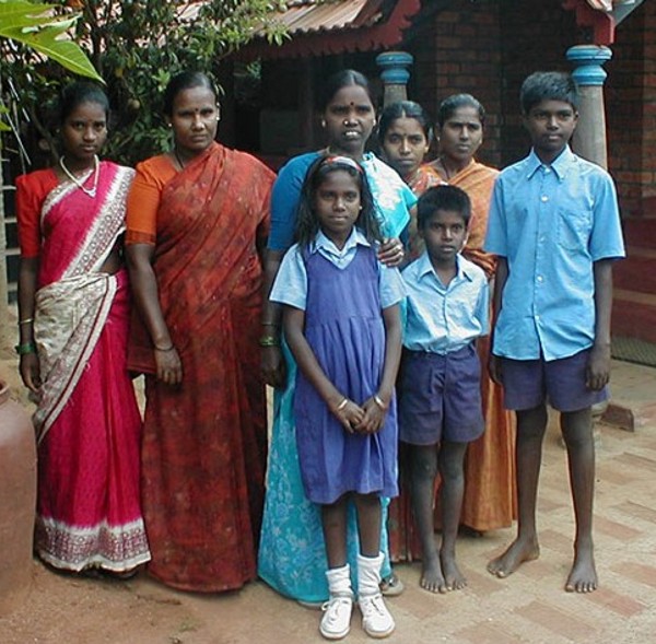
Mashpee Wampanoag Tribe enrollment day
Note the color of the children; there are few showing any sign of Blackness. It won't be long before the Sachem is
Albino.
And then it won't be long before Albino textbooks swear that
the Wampanoag were Albinos.
|
Troops from Connecticut composed of colonists and their Mohegan allies
swept into Rhode Island and killed substantial numbers of the
now-weakened Narragansetts. A force of Mohegans and Connecticut militia
captured Narragansett sachem Canonchet a few days after the destruction
of Providence Plantations, while a force of Plymouth militia and
Wampanoags hunted down Metacomet. During the summer months, Philip
escaped from his pursuers and went to a hideout on Mount Hope in Rhode
Island. Colonial forces attacked in August, killing and capturing 173
Wampanoags. Philip barely escaped capture, but his wife and their
nine-year-old son were captured and put on a ship at Plymouth. They
were then sold as slaves in the West Indies. On August 12, 1676,
colonial troops surrounded Philip's camp, and soon shot and killed him.
With the death of Metacomet and most of their leaders, the Wampanoags
were nearly exterminated; only about 400 survived the war. The
Narragansetts and Nipmucks suffered similar rates of losses, and many
small tribes in southern New England were finished. In addition, many
Wampanoag were sold into slavery. Male captives were generally sold to
slave traders and transported to the West Indies, Bermuda, Virginia, or the Iberian Peninsula.
The colonists used the women and children as slaves or indentured
servants in New England, depending on the colony. Massachusetts
resettled the remaining Wampanoags in Natick, Wamesit, Punkapoag, and
Hassanamesit, four of the original 14 praying towns. These were the
only ones to be resettled after the war. Overall, approximately 5,000
Indians (40 percent of their population) and 2,500 colonists (5
percent) were killed in King Philip's War.

|
As
we can see from this current photo, Kayla and Kaitlyn Balbuena are
still Black, and still members of the Wampanoag tribe. This picture
also tells us that as "Full-Blood" Wampanoag like the sisters are
forced to defend their citizenship, more and more "Mulattoes" slip in
and take up positions of power. So that like Rita Lopez, they get to decide "WHO" is a Wampanoag.
|
The exception to relocation was the coastal islands' Wampanoag
groups,
who had stayed neutral through the war. The colonists forced the
Wampanoag of the mainland to resettle with the Saconnet (Sekonnet), or
with the Nauset into the praying towns in Barnstable County. Mashpee is
the largest Indian reservation set aside in Massachusetts, and is
located on Cape Cod. In 1660, the colonists allotted the natives about
50 square miles (130 km2) there, and beginning in 1665 they had
self-government, adopting an English-style court of law and trials.
Mashpee sachems Wepquish and Tookenchosin declared in 1665 that this
land would not be able to be sold to non-Mashpee without the unanimous
consent of the tribe, writing "We freely give these lands forementioned
unto the South Sea Indians and their children forever: and not to be
sold or given away from them by anyone without all their consents
thereunto." An Indian Deed relating to the Petition of Reuben Cognehew
presented a provision established by a representative of the community
named Quatchatisset establishing that the allotment would " for ever
not to be sold or given or alienated from them [his descendants] or any
part of these lands." Property deeds in 1671 recorded this area known
as the Mashpee Plantation as consisting of around 55 square miles of
land. The area was integrated into the district of Mashpee in 1763. In
1788 after the American Revolutionary War, the state revoked the
Wampanoag ability to self-govern, considering it a failure. It
appointed a supervisory committee consisting of five European-American
members, with no Wampanoag.
Bermuda
Ina Christina Millett Lugo, like many born
and raised on Bermuda’s St. David’s Island, grew up believing she was
descended from Native American war captives shipped from New England in
the 1600s as slaves. She had no documents to prove it, only stories
that had been passed down through generations. “The way the story has
been told, King Philip's wife and son were brought here,” said Lugo’s
daughter Terlena Murphy, referring to Metacom, a 17th century Wampanoag
tribal leader in New England who went on to adopt the English moniker.
“Mother and son were separated,” added Murphy, who chairs the St.
David's Islanders and Native Community (SDINC). “The mother went to an
area called Bailey's Bay, along Bermuda’s North Shore, and the son may
have come to St. David's.”

|
As Harvard University historian Jill Lepore details in “The Name of
War,” in June 1675, Metacom launched a war of resistance against
English colonists in southeastern New England. Fourteen months into
what came to be known as “King Philip’s War,” colonial soldiers hunting
for Metacom captured his wife, Wootonekanuske, and their young son.
According to Lepore, Plymouth officials and clergy spent months
debating what to do with the boy, who was only 9 years old. In the end,
they sold him into foreign slavery. Lepore says there is no record of
what happened to Wootonekanuske. Lugo also learned that Puritan
colonists had shipped dozens of Pequot men to Bermuda at the end of the 1637 Pequot War.
In 1995, says Murphy, her mother traveled to New England to further
research her roots. Cousin Stuart Hollis accompanied her on the trip.
“One day while they were walking in Massachusetts,” said Murphy, “they
thought they were close to the Mashpee Wampanoag Reservation, but they
weren’t.” A car passed them on the road. The driver stopped to offer
them a ride. “I guess he was wondering, ‘Why are these two people who
don't look like they're from here out walking?’” Murphy said. The
driver turned out to be David Weeden, historic preservation officer for
the Mashpee Wampanoag Tribe and the son of Everett "Tall Oak" Weeden,
an elder, activist and historian who is also Pequot. “And as it turned
out, Tall Oak had been looking for us for a long time, as well,” said
Murphy.

|
‘Mohawks’
Bermuda, once known as Somers Island, sits in the Atlantic Ocean about
1,000 kilometers east of North Carolina. A cluster of seven main
islands — including the 202-hectare strip that is St. David’s — Bermuda
was uninhabited until 1609, when a British ship landed on its coast. In
her 1999 book, “Slaves and Slaveholders in Bermuda,” Virginia Bernhard
explains that the Virginia Company soon afterward sent several dozen
English colonists to Bermuda to establish a permanent settlement. In
1637, Bernhard writes, Massachusetts sent at least 80 Pequot War captives to Bermuda.
Many were purchased by St. David’s colonists, and even more Native
prisoners were sent to Bermuda at the end of King Philip’s War in the
1670s.
“As the years passed, these and other Indians on St. David’s formed
families, sometimes mixing races, but still preserving stories of their
ancient Indian origins, if not their tribal cultures, to pass down
through generations into the 20th century,” Bernhard wrote. Many
Islanders today carry surnames that date back to a 1662 survey of
Bermuda’s earliest landholders — Fox, Higgs and Tucker. And many
islanders trace their ancestry to Jacob Minors, portrayed in an 1879
history of Bermuda with the caption, “…a native Bermudian of strongly
marked Indian features; reputed to be of Indian descent, and probably
descending from one of the Pequot captives.”

|
Eighty-year-old St. Clair “Brinky” Tucker is one of the founding
members of the St. David’s Island Indian Committee (SDIIC), as the
SDINC was originally known. He is also the author of “St. David's
Island, Bermuda: Its People, History and Culture.” “My mother grew up
on the Island,” Tucker said. “She told me that she was a Mohawk. She
always said to me, ‘Don't forget, that's your heritage. You are part
Indian.’” Mohawk, according to both Murphy and Tucker, was the generic
pejorative Bermudians used for St. David’s islanders. St. David’s
community was self-sustaining. “The men were fishermen and farmers, and
the women, apart from cooking and looking after the household, picked
Easter lilies,” Tucker said, referring to a white flower that was once
a major export crop. “They lived a very simple life and even developed
their own way of speaking.” Their Indian heritage, said Tucker, was
something they spoke of only amongst themselves.
Reunion
In July 2002, a delegation of Wampanoag, Pequot and Narragansett tribe
members traveled to Bermuda to participate in a “Reconnection Indian
Festival,” organized by original SDIIC members under Brinky’s
leadership. The group convened at a place called Dark Bottom, which
Murphy said was a historic gathering place for St. David’s Native
slaves. That event has evolved into a biannual pow wow. “We burn a fire
and, standing in a circle, we honor the ancestors, say prayers and
thanks, and welcome our visitors,” Murphy said. The COVID-19 pandemic
forced them to cancel their June 2020 gathering. Murphy said she is
hopeful that by 2022, everyone will feel comfortable enough to travel
again.
Though we call the Wampanoag the Dumbest Niggers, we must still
congratulate them for at least maintaining a Black leadership structure
for the tribe. This is quite different from the Tribes in the west,
which invariably have Albinos in leadership positions. This
happened because Albinos used their fellow Albinos in government to rig
it so that Albinos could claim Tribal membership, elect each other to
positions of power, then steal what they want at will. Central to this
Scheme was the "DAWES ROLLS."
|
The Dawes Act
The Dawes Act of 1887 (also known as the General Allotment Act or the
Dawes Severalty Act of 1887) regulated land rights on tribal
territories within the United States. Named after Senator Henry L.
Dawes of Massachusetts, it authorized the President of the United
States to subdivide Native American tribal communal landholdings into
allotments for Native American heads of families and individuals. This
would convert traditional systems of land tenure into a
government-imposed system of private property by forcing Native
Americans to "assume a capitalist and proprietary relationship with
property" that did not previously exist in their cultures. Before
private property could be dispensed, the government had to determine
which Indians were eligible for allotments, which propelled an official
search for a federal definition of "Indian-ness".
|

|

|

|
If you wonder how many generations does it take to turn an Albino (type
2) into a "NORMAL" Human, here is a demonstration using a "BROWN"
skinned Black (already admixed with Albino - perhaps recently, perhaps
thousands of years ago.). If a "FULL NORMAL HUMAN" were used,
"Full Black" it would take a generation or two more to get these
results.
Why is this important to the Wampanoag Tribe?
JUST LOOK WHAT'S WAITING FOR THEM TO LOWER THEIR GUARD
The Iroquois
The Iroquois are a group of American Indians from the modern-day
northeastern United States and Canada. The word “Iroquois” is a French
word, derived from a Huron word meaning “black snakes.” They are also
known officially as the “Haudenosaunee” and were also called the
Six Nations by the English. Haudenosaunee can be translated to “People
of the Longhouse.” According to oral history, five nations banded together over 1,000
years ago to form a union. The five nations were the Mohawk, Cayuga,
Seneca, Oneida and Onondaga. In 1722, the Tuscarora joined the union
making the confederacy Six Nations.

|
A Council of Chiefs served as the Iroquois governing authority,
however, the Six Nations function under the Great Law of Peace, an oral
constitution that was first created sometime around 1142 and was later
written on wampum belts. The Iroquois Confederacy established that each
nation should handle their own affairs. The Great Law of Peace is a
unique representational form of government, with the people in the
clans having say in what information is passed upward. Legend has it
that Benjamin Franklin used many aspects of the Iroquois system in the
development of America's government.
The Iroquois are considered a matrilineal society because descent is
passed through the mother, rather than the father. Both men and women
have equal roles in the social, political and economic life of the
community. The balance of the gender roles makes the society unique.
For example, children of either sex are affiliated with their mother’s
clan.
For the Iroquois, the clan is the basic unit of social organization.
Members of one clan are considered relatives and intermarriage in the
same clan is forbidden. Each clan is led by a Clan Mother. The
responsibilities of the Clan Mother include the naming of all those in
the clan, as well as the selection of the male candidate for Chief,
which the rest of the Clan must approve. She can however remove that
same chief if he fails in his duties.

|
The Haudenosaunee grew a variety of vegetables, such as corn, beans,
and squash. Hunting and fishing contributed to part of the food they
ate. They also grew tobacco that was used for ceremonial and medicinal
purposes. The men and boys usually hunted for deer, bear and small
mammals. Although hunting was accomplished by bow and arrow, many also
used guns they traded Europeans for.
The Iroquois lived in villages with long wooden buildings called
“longhouses.” Families would live together in the structures with
extended family members. The Haudenosaunee viewed the concept of the
longhouse like six families living under one roof, with each nation
representing a family.

|
| 
|
The Iroquois Nations could be described as similar to a large
longhouse
that extends from where the sun rises in the east, to where it sets in
the west. the earth is the floor of this longhouse and the sky is
considered the roof. In this great longhouse, the Mohawk nation are the
keeper of the eastern door. The Seneca is the keeper of the western
door. The Onondagas in the middle are the keepers of the central fire.
Together these three are referred to as the elder brothers and they
represent half of the longhouse families. The Cayuga, Oneida, and
Tuscarora nations are the younger brothers and they represent the other
families that complete the house. Today, longhouses still exist on some
Haudenosaunee reservations and are used for ceremonial purposes. The
Iroquois people have inhabited the areas of Ontario and upstate New
York for well over 4,000 years.
Abenaki People
The Abenaki are an Indigenous peoples of the Northeastern Woodlands of
Canada and the United States. They are an Algonquian-speaking people
and part of the Wabanaki Confederacy. During much of the 17th century,
the Abenaki were hunters, fishers and gatherers. Favoured game was more
often moose than deer. They travelled mainly by birchbark canoes on
lakes and streams, and lived in villages near waterfalls on major
rivers during the seasons when migratory fish could be harvested. The
Wabanaki Confederacy is a North American First Nations and Native
American confederation of four principal Eastern Algonquian nations:
the Mi'kmaq, Maliseet, Passamaquoddy and Penobscot.
The History and Culture of the Ojibwe (Chippewa) Tribe
The Anishinaabeg (singular Anishinaabe) is the umbrella name for the
Ojibwe, Odawa, and Potawatomi nations. The names "Ojibwe" and
"Chippewa" are essentially different spellings of the same word,
"otchipwa," which means "to pucker," a likely reference to the
distinctive puckered seam on an Ojibwa moccasin. According to
tradition, which is supported by linguistic and archaeological studies,
the ancestors of the Anishinaabeg migrated from the Atlantic Ocean, or
perhaps Hudson Bay, following the St. Lawrence Seaway to the Straits of
Mackinac, arriving there about 1400.

|

|
The Ojibwe people were primarily located in the
Great Lakes region of Western New York, Wisconsin, Michigan, Minnesota,
and southern Quebec and Ontario. Uniquely positioned between early
French and British settlers, they built relationships with both and
engaged in trade and commerce across the region. Along the Great Lakes,
the forests were teeming with game, and the water was abundant with
fish. The Ojibwe were able to create a thriving trade economy and
enjoyed a healthy lifestyle fueled by the area's natural resources.
Fishing, trapping, and hunting provided everything the Ojibwe people
needed, plus a surplus they could trade with settlers in exchange for
clothing, medicine, guns, and more. While spread out across a great
area, the lakes connected the Ojibwe people, who were able to create a
shared sense of identity and community. The Ojibwe people moved
westward along the Great Lakes because of a prophecy that they were to
go find "the land where food grows on water." This food was wild rice,
also called manoomin. The Ojibwe traveled the lakes in their birch bark
canoes, staying close to the water as they migrated and established
camps. They relied on fish more than hunting land animals to sustain
them on their journeys.
|
RICE (wild)
Northern wild rice (Zizania palustris) is an annual plant native to the
Great Lakes region of North America, the aquatic areas of the Boreal
Forest regions of Northern Ontario, Alberta, Saskatchewan and Manitoba
in Canada and Minnesota, Wisconsin, Michigan and Idaho in the US.
Archaeological and genetic insights into the origins of domesticated rice.
Rice (Oryza sativa) is one of the most important cereal grains in the
world today and serves as a staple food source for more than half of
the world’s population. Research into when, where, and how rice was
brought into cultivation and eventually domesticated, along with its
development into a staple food source, is thus essential. Current
findings from genetics and archaeology are consistent with the
domestication of O. sativa japonica in the Yangtze River valley of
southern China, it appears rice was cultivated in the area by as early
8,000 BP
|
The Ojibwe Language
Stemming from the Algonquian language family, the Ojibwe
language has a series of dialects and writing systems. This language
and its dialects are the 2nd most commonly spoken First Nations
language in Canada and the 4th most widely spoken First Nations
language in the United States. The language itself is closest to the
language of the Potawatomi tribe in its patterns, and it's one of the
largest Algic languages by the number of speakers. Because of its
popularity and ease in comprehension across tribes and dialects, this
language has been used as a trade language.
| As you will see the Ojibwe/Chippewa people became very "Integrated" with Mongols and Albino Wives. |
The White Earth Band of Ojibwe/Chippewa
The White Earth Band of the Minnesota Chippewa Tribe, also called the
"White Earth Nation" (Ojibwe: lit. "People from where there is an
abundance of white clay"), is a federally recognized Native American
band in northwestern Minnesota. The band's land base is the White Earth
Indian Reservation. With 19,291 members in 2007, the White Earth Band
is the largest of the six component bands of the federally recognized
Minnesota Chippewa Tribe, formed after the 1934 Indian Reorganization
Act. It is also the largest band in Minnesota. The five other member
tribes of the Minnesota Chippewa Tribe are the Bois Forte Band (Nett
Lake), Fond du Lac Band, Grand Portage Band, Leech Lake Band, and Mille
Lacs Band.
History
The White Earth Nation was formed by joining multiple Chippewa bands
from north central Minnesota. They had been displaced by
European-American settlement and consolidated onto a reservation in
Mahnomen, Becker, and Clearwater Counties. Six Minnesota Chippewa bands
enroll members separately today, but they combine numbers when
identifying the entire tribe. According to the Minnesota Chippewa Tribe
council, the White Earth Band had 19,291 enrolled members in July 2007,
making it the largest Anishinaabe tribe in the state.
On March 19, 1867, the U.S. Congress established the White Earth Indian
Reservation for the Mississippi Chippewa Indians in Minnesota,
following the ratification of a treaty between them and the United
States. Congress had several session agreements regarding the White
Earth Band of Ojibwe. After hearing many complaints about the
Pillagers, who were then landless, Congress authorized the relocation
of the western Pillagers to the White Earth Indian Reservation. They
were not included in the 1855 Treaty of Washington (10 Stat. 1165),
which was made with the eastern Pillagers at the Mississippi River
headwaters. Eventually, the Otter Tail Pillager Band of Chippewa
Indians and Wild Rice River Pembina Band of Chippewa Indians also came
to settle alongside the Mississippi Chippewa at White Earth Reservation
and effectively became part of the White Earth Band.
These historic bands were:
Gull Lake Band of Mississippi River Chippewa
Removable Mille Lacs Indians
Rabbit Lake Band of Mississippi River Chippewa
Rice Lake Band of Mississippi River Chippewa.[citation needed]
Until the Indian Reorganization Act of 1934, the six bands living on
the White Earth Indian Reservation acted independently of each other.
After the Reorganization Act, the six wrote a constitution forming the
Minnesota Chippewa Tribe. Minnesota was divided into six tribal
districts uniting all Ojibwe bands not associated with the Red Lake
Band of Chippewa, and the Pembina band. Both refused to relocate to
White Earth, thus maintaining their individual identities.
FIRST INDIAN GOVERNOR OF A U.S. STATE MAY BE IN THE OFFING!
Minnesota Lt. Gov. Peggy Flanagan joins MSNBC's Jonathan Capehart for
her first national cable news interview. If Governor Walz wins
(candidate for U.S. Vice-President) she will become the Ha,Ha,Ha "First
Native American Governor to lead a State" - by virtue of replacing Walz
as Minnesota Governor.
What makes it so funny is that THIS IS "Peggy Flanagan". Is there a
more Albino looking Woman? Is there a more Albino name than Peggy
Flanagan? All Albino media proudly proclaims this news because in their
delusional minds it's perfectly reasonable that "ALL" HUMANS WOULD LOOK
LIKE THEM! Think about what you see in movies and T.V. Martians, and
other Space People always look like our Albinos, even though our
Albinos are the LEAST numerous of all Humans. There are plenty of Black
actors, the most numerous people, there are plenty of Mongol actors,
the second most numerous people, but our Albinos always prefer other
Albinos because that's the only time they feel safe - among their own
kind.

|
Flanagan grew up in Saint Louis Park, Minnesota, an inner-ring suburb
of Minneapolis. She is a citizen of the White Earth Nation. The
daughter of American Indian land rights and sovereignty activist Marvin
Manypenny, Flanagan was raised by a single mother (we assume that is
where the Flanagan name comes from) a phlebotomist, in St. Louis Park,
Minnesota. She is of Irish and Ojibwe descent. The White Earth
Reservation is named for the layer of white clay underneath the surface
on the western half of the reservation. The land is typical of
west-central Minnesota - prairie in the west, rolling hills and many
lakes and rivers in the middle, and conifer forest in the east.
Aren't we all - at least I am:
Tired of our Albinos making believe they are "US" simply
by virtue of having a few drops of Melanin producing
Blood from their Black Fathers or Mothers?
They are our Children - Yes: because we made them.
But they are NOT US.
And these Albinos and their Mulattoes have no business on a Chippewa Tribal Council.
The Blackfoot
The Blackfoot Confederacy, meaning "the people" or
"Blackfoot-speaking real people", is a historic collective name for
linguistically related groups that make up the Blackfoot or Blackfeet
people: the Siksika ("Blackfoot"), the Kainai or Blood ("Many Chiefs"),
and two sections of the Peigan or Piikani ("Splotchy Robe") – the
Northern Piikani (Aapátohsipikáni) and the Southern Piikani (Amskapi
Piikani or Pikuni). Broader definitions include groups such as the
Tsúùtínà (Sarcee) and A'aninin (Gros Ventre) who spoke quite different
languages but allied with or joined the Blackfoot Confederacy.

|
Historically, the member peoples of the Confederacy were nomadic bison
hunters and trout fishermen, who ranged across large areas of the
northern Great Plains of western North America, specifically the
semi-arid shortgrass prairie ecological region. They followed the bison
herds as they migrated between what are now the United States and
Canada, as far north as the Bow River. In the first half of the 18th
century, they acquired horses and firearms from white traders and their
Cree and Assiniboine go-betweens. The Blackfoot used these to expand
their territory at the expense of neighboring tribes.

|
Today, three Blackfoot First Nation band governments (the Siksika,
Kainai, and Piikani Nations) reside in the Canadian province of
Alberta, while the Blackfeet Nation is a federally recognized Native
American tribe of Southern Piikani in Montana, United States.
Additionally, the Gros Ventre are members of the federally recognized
Fort Belknap Indian Community of the Fort Belknap Reservation of
Montana in the United States and the Tsuutʼina Nation is a First Nation
band government in Alberta, Canada.
Winnipeg Jack, Blackfoot Indian, North West Mounted Police scout and interpreter, about 1890.
The Lummi
The Lummi Nation, are a Native American tribe of the Coast Salish
ethnolinguistic group in western Washington state in the United States.
They continue to speak the traditional Salishan language. They
expressed their language and religious traditions through elaborate
carvings on totems and ceremonies. Before the arrival of Europeans, the
Lummi lived in a large area that included much of today's Puget Sound
area in Washington State and British Columbia, Canada. They established
villages near the sea and in the forests, and moved according to the
seasons. They lived in multi-family cedar-plank longhouses.
The Osage
Osage, original name Ni-u-kon-ska (“People of the Middle Waters”),
North American Indian tribe of the Dhegiha branch of the Siouan
linguistic stock. The name Osage is an English rendering of the French
phonetic version of the name the French understood to be that of the
entire tribe. It was thereafter applied to all members of the tribe.
The name Wa-zha-zhe (“Water People”), however, refers to only a
subdivision of the Hunka (Hunkah; “Earth People”), one of the two
ancient kin groups—the other was the Tzi-zho (Tzi-sho; “Sky
People”)—from which the tribe descended.

|
Quite a
confusing photograph; Note the little boy standing in the middle is
extremely Black, as is normal, but the teenage boy sitting in the front
on the left is an Albino, and the boy on his left appears to be a
Mulatto.We don't know who wrote the caption or what was the point.
|
Like other members of the Dhegiha—the Omaha, Ponca, Kansa, and
Quapaw—the Osage migrated westward from the Atlantic coast, settling
first in the Piedmont Plateau between the James and Savannah rivers in
the present states of Virginia and the Carolinas. After a time they
moved to the Ozark Plateau and the prairies of what is now western
Missouri. At this point the five tribes separated, with the Osage
remaining in villages on the Osage River, where Jacques Marquette
recorded their location in 1673. They remained there until the early
19th century, when they ceded their Missouri lands to the United States
government and moved west to the Neosho River valley in Kansas. After
settling on the Kansas reservation, the Osage were notable for their
persistent rejection of the dominant American culture; they continued
to dress in traditional clothing and to build traditional homes. They
also discouraged the use of alcohol, which had been introduced by
traders.

|
Traditional Osage culture was typical of many Plains Indians and
involved a combination of village-based agriculture and nomadic bison
hunting. Other important game animals were deer, bear, and beaver.
Osage villages consisted of longhouses covered with mats or skins and
arranged irregularly about an open space used for dances and council
meetings. Tepees were used during the hunting season. Osage life
centred on religious ceremonials in which clans were divided into
symbolic sky and earth groups, with the latter further subdivided to
represent dry land and water. The Osage were remarkable for their
poetic rituals. Among them was the custom of reciting the history of
the creation of the universe to each newborn infant.

|
Following the American Civil War (1861–65), pressure on the U.S.
government to open all Native American lands to emigrant settlement
resulted in the sale of the Kansas reservation. The proceeds were used
to purchase land for the Osage in Indian Territory (present-day
Oklahoma). The discovery of oil on the Osage reservation in the late
19th century and an agreement with the U.S. government by which all
mineral rights on the reservation were to be retained by the tribe,
with royalties divided on a per capita basis, made the Osage quite
prosperous. Early 21st-century population estimates indicated some
16,000 individuals of Osage descent.
The Washoe Tribe
As the Wašiw (Washoe) creation story goes, the Washoe people were
brought to their homeland surrounding Lake Tahoe by Gewe (the coyote)
and told that this area is the place that the goddess, Nentašu, meant
for them to be. Nentašu then told all of the plants, medicines, and
animals of this place to grow strong in order to provide nourishment
for the Washoe and she reminded the people of their responsibility to
care for this place.

|
One of several creation stories, the geographic and spiritual center of
the Washoe world is “Da ow ga” (Lake Tahoe). Like most native people,
the Washoe lifestyle revolved around the environment as the people were
part of the environment and everything was provided by the environment.
Washoe tradition indicates their homeland has always included Lake
Tahoe. Archeologists trace the Washoe presence at Lake Tahoe back at
least two thousand years, with the lake and approximately 10,000 square
miles of land surrounding the lake once home to and the responsibility
of Lake Tahoe’s original locals.
History of the Paiutes
Scholars suggest that the
Southern Paiutes and other Numic speaking peoples began moving into the
Great Basin and Colorado Plateau around 1000 A.D. Prior to contact with
Europeans, the Paiutes’ homeland spanned more than thirty million acres
of present-day southern California, southern Nevada, south-central
Utah, and northern Arizona. Their lifestyle included moving frequently,
primarily according to the seasons and plant harvests and animal
migration patterns, and they lived in independent groups of three to
five households. Major decisions were made in council meetings. The
traditional Paiute leader, called niave, offered advice and suggestions
at council meetings and would later work to carry out the council’s
decisions.
The Spanish settlement of the
American Southwest brought disruption and violence to the Southern
Paiutes. Most importantly, the Spanish introduced the violent slave
trade to Great Basin Indians. Because the Paiutes did not adopt the
horse as a means of transportation, their communities were frequently
raided for slaves by neighboring equestrian tribes, New Mexicans, and,
eventually, Americans. Slave trafficking of Paiutes increased after the
opening of the Old Spanish Trail, a trade route that connected New
Mexico to the Pacific Ocean. The demand was highest for children,
especially girls.

|
Though the mid-1800s the Southern
Paiutes had encountered Euro-American traders, travelers, and trappers,
but they had not had to deal with white settlement on their lands. In
1851, however, members of the LDS Church began colonization efforts in
the area of southern Utah, and by the end of 1858, Mormons had
established eleven settlements in Southern Paiute territory. Initially,
the Paiutes welcomed the Mormon presence, as it offered them some
protection against raiding Utes, Navajos, and Mexicans. Unfortunately,
Mormon settlement also brought sweeping epidemics. In the decade
following settlement, some Paiute groups lost more than ninety percent
of their population to disease. Eventually, the large number of Mormon
settlers also led to competition over Paiute lands and resources.
One of the most controversial
events involving the Southern Paiutes occurred in September 1857 near
what is now Cedar City, Utah. At the Mountain Meadows Massacre, more
than one hundred emigrants bound for California were attacked and
murdered. For over a century, the common history was that Paiute
Indians first attacked the wagon train. The Paiutes then supposedly
appealed to LDS settlers for aid, and the settlers approached the
emigrants under a flag of truce. After convincing the emigrants to give
up their weapons, the settlers led the wagon train to a secluded spot
where they subsequently slaughtered most of the emigrants. Here again
the Mormons claimed that Paiute Indians took part in the treachery, and
for years the Paiutes bore the brunt of the blame for this tragic
event. While many aspects of the massacre are still shrouded in
mystery, it is important to stress that Paiute oral tradition strongly
indicates that the Paiutes did not participate in either the initial
attack or the following massacre.

|
The first Paiute reservation was
established in 1891 on the Santa Clara River west of St. George. The
reservation was formally recognized by the government in 1903. In 1916
President Woodrow Wilson issued an order which expanded the size of the
reservation to its current 26,880 acres. Three other Paiute
reservations soon followed. The reservations proved too small and
resource-poor for the Paiutes to sustain themselves, and the Paiutes
were often dependent on Mormon charity and the federal government’s
good will. That good will ended abruptly in the 1950s under the federal
government’s policy of termination, which was intended to enforce
assimilation and encourage self-sufficiency among Indian tribes but
instead had devastating social and economic consequences. Prior to
1954, each Paiute band, except the Cedar Band, had its own reservation
and functioning tribal government. However, under termination these
bands lost federal recognition and, therefore, their eligibility for
federal support. Many reports indicating that the Paiute tribe was not
prepared for termination, and it is still a mystery as to why they were
selected to be part of the program. The Paiutes suffered immensely
under termination. Nearly one-half of all tribal members died during
the period between 1954 and 1980, largely due to a lack of basic health
resources. Without adequate income to meet their needs, the Paiutes
could not pay property taxes and lost approximately 15,000 acres of
former reservation lands. A less tangible, but equally important,
result was the Paiutes’ diminishing pride and cultural heritage.

|
In the early 1970s the Paiutes
began concerted efforts to regain federal recognition. Finally, in 1980
Congress restored the federal trust relationship to the five bands,
which were reorganized as the Paiute Indian Tribe of Utah. Under
restoration, the Paiutes received 4,770 acres of generally marginal
reservation land scattered through southwestern Utah, only a fraction
of the land they had lost under termination. Today the Paiute tribal
government has improved healthcare and education on the reservations,
and the Paiute Economic Development is working to create job
opportunities close to home. With a landbase now in place, the Paiutes
are finally becoming a visible presence in southern Utah. Their annual
Restoration Gathering brings attention to the pride and heritage of the
Paiute people.
Comanche
Quote: We are the Comanche Nation and in our native language “Nʉmʉnʉʉ”
(NUH-MUH-NUH) which means, “The People”. We are known as “Lords of the
Plains” and were once a part of the Shoshone Tribe. In the late 1600’s
and early 1700’s, we moved off from our Shoshone kinsmen onto the
northern Plains and then southerly in search of a new homeland. We
Migrated across the Plains, through Wyoming, Nebraska, Colorado,
Kansas, New Mexico, Texas, and Oklahoma. We ultimately settled here in
Southwest Oklahoma. The horse was a key element in Comanche culture.
The people mastered their skills on horseback and gained a tremendous
advantage in times of war. They fought battles on horseback which was a
skill unknown among other Indian peoples of that time. They were highly
skilled at breeding and trading the horse, which became an important
resource for the people that radically changed life on the plains.
Comanche horsemen set the pattern of nomadic equestrian life that
became characteristic of the Plains tribes in the 18th and 19th
centuries. Bands of the Comanche were formed on the basis of
kinship and other social relationships. The buffalo was also an
important resource for the people. It provided food, clothing, tepee
covering, and a wide variety of other goods for economical purposes.
It appears that the Comanche were a mostly Mongol Tribe, which is agreement with them being a
"Northern Plains" tribe: (proximity to the Bering land bridge - Asia to America crossing).
History of the Shoshone People
The Northwestern Band of Shoshone
is a branch of the larger group of Shoshone people that cover Utah,
Idaho, Wyoming, and Nevada. When whites began encroaching on the area
that is now Utah in the 1840s, three different groups of Northwestern
Shoshones lived there. The misnamed Weber Utes lived in Weber Valley
near present-day Ogden, Utah. The Pocatello Shoshones dwelt between the
northern shore of the Great Salt Lake and the Bear River. A third group
lived in the Cache Valley along the Bear River. They called themselves
kammitakka, which means “jackrabbit-eaters.”

|
The Shoshone people were very
mobile and skilled at hunting and gathering, and with each change of
the season they migrated to obtain the food and other resources they
depended on to survive. In the early autumn, the Northwestern Shoshones
moved into the region near what is now Salmon, Idaho, to fish. After
fishing was over, they moved into western Wyoming to hunt buffalo, elk,
deer, moose, and antelope. They sun-dried the meat for winter and used
the hides as clothing and shelter. In the spring and summer, the
Northwestern Shoshones traveled around southern Idaho and throughout
Utah. During these months, they spent their time gathering seeds,
roots, and berries and socializing. In late summer they dug roots and
hunted small game. Around late October, the band moved into western
Utah and parts of Nevada for the annual gathering of pinyon nuts (or
pine nuts), a nutrient-rich food that formed an important part of the
Shoshone diet. The wintering home of the Northwestern Shoshones was in
an area around what is now Preston, Idaho. Based on these migration
patterns, experts have claimed that the Northwestern Shoshones were
among the most ecologically efficient and well-adapted Indians of the
American West.

|
By the 1840s, the Northwestern
Shoshones had adopted some aspects of Plains Indian culture, using the
horse for mobility and to hunt large game, such as buffalo. The
Shoshone way of life came under attack when Anglo emigrants began to
transverse Shoshone lands on the trails to California and Oregon in the
early 1840s. The arrival of the members of the LDS Church in 1847
brought added pressure. The Mormons initially settled in the Salt Lake
Valley but quickly spread into the Weber and Cache Valleys, entering
Shoshone lands and competing for vital resources. Conflict between the
Shoshones and white settlers and emigrants became a serious problem in
the late 1850s and early 1860s. Responding to the destruction of game
and grass cover and the unprovoked murder of Indians, Shoshone leaders
like Chief Pocatello retaliated with raids on emigrant trains. After
the discovery of gold in Montana in 1862, more and more whites traveled
over Shoshone land. In response to incidents of violence committed by
the travelers, some Shoshones, including a group led by Chief Bear
Hunter of the Cache Valley, began to raid wagon trains and cattle herds.
Violence erupted on January 29,
1863 when Colonel Patrick Edward Connor and about two-hundred army
volunteers from Camp Douglas in Salt Lake City attacked Bear Hunter’s
people. A group of 450 Shoshone men, women, and children were camped on
the Bear River twelve miles from Franklin, Washington Territory (now
Idaho). In the early hours of the morning, Connor and his men
surrounded the Shoshones and began a four-hour assault on the virtually
defenseless group. Some 350 Shoshones were slaughtered by the troops,
including many women and children. This was one of the most violent
events in Utah’s history and the largest Indian massacre in U.S.
history.
In the aftermath of the Bear River
Massacre, white settlers moved unopposed into traditional Northwestern
Shoshone lands. As American settlements grew around them, the few
remaining Northwestern Shoshones lost their land base and could no
longer sustain their traditional nomadic lifestyle. In 1875, after
years of struggle and starvation, many Northwestern Shoshones converted
to Mormonism and settled on a church-sponsored farm near Corrine, Utah,
an area where the Shoshone had traditionally wintered. The farm was
short-lived, as federal officials, responding to unfounded rumors that
the Shoshones were planning an attack on Corrine, expelled them from
the farm and attempted to force them onto the newly founded Fort Hall
Reservation in Idaho.
Some Northwestern Shoshones did
move to Fort Hall, but those who wanted to remain in their traditional
homeland were left without a reservation and had to search for
alternative means to secure a land base. Beginning in 1876, using
rights guaranteed under the Homestead Act, the Northwestern Shoshones
acquired and settled land between the Malad and Bear rivers. The Malad
Indian Farm was eventually discarded due to its insufficient size and
the difficulty of irrigating in the area. The Northwestern Shoshones
considered moving back to the Cache Valley but instead moved to a new
farm in the Malad Valley just south of Portage, Utah. They named the
farm after their admired leader Washakie, and the settlement, which was
managed by members of the LDS Church, was home the Northwestern Band of
Shoshone for the next eighty years. Tragically, in the summer of 1960,
representatives of the LDS Church, who mistakenly believed that
Washakie had been abandoned, burnt the Shoshones’ houses to the ground
in preparation for the sale of the church farm. The church later gave
the band 184 acres of land near Washakie to atone for this mistake.
Until 1987, the Northwestern Band
of Shoshone was administered by the federal government as part of a
larger Shoshone tribe. That year the government recognized the tribe as
independent, and the Northwestern Shoshones adopted a constitution and
tribal council. In addition to the Washakie land, the tribe holds some
private lands held in trust by the Bureau of Indian Affairs and is
attempting to purchase more land to solidify its home in Utah. The
Northwestern Band of Shoshone is quickly developing and, in so doing,
is reasserting its rightful place in the history of Utah.
The Nez Perce
The Nez Perce War was an armed conflict in 1877 in the Western United
States that pitted several bands of the Nez Perce tribe of Native
Americans and their allies, a small band of the Palouse tribe led by
Red Echo (Hahtalekin) and Bald Head (Husishusis Kute), against the
United States Army. Fought between June and October, the conflict
stemmed from the refusal of several bands of the Nez Perce, dubbed
"non-treaty Indians," to give up their ancestral lands in the Pacific
Northwest and move to an Indian reservation in Idaho Territory. This
forced removal was in violation of the 1855 Treaty of Walla Walla,
which granted the tribe 7.5 million acres of their ancestral lands and
the right to hunt and fish on lands ceded to the U.S. government.

|

|
|

|
After the first armed engagements in June, the Nez Perce embarked on an
arduous trek north initially to seek help with the Crow tribe. After
the Crows' refusal of aid, they sought sanctuary with the Lakota led by
Sitting Bull, who had fled to Canada in May 1877 to avoid capture
following the 1876 Battle of the Little Bighorn. The Nez Perce were
pursued by elements of the U.S. Army with whom they fought a series of
battles and skirmishes on a fighting retreat of 1,170 miles (1,880 km).
The war ended after a final five-day battle fought alongside Snake
Creek at the base of Montana's Bears Paw Mountains only 40 miles (64
km) from the Canada–US border. A large majority of the surviving Nez
Perce represented by Chief Joseph of the Wallowa band of Nez Perce,
surrendered to Brigadier Generals Oliver Otis Howard and Nelson A.
Miles.[3] White Bird, of the Lamátta band of Nez Perce, managed to
elude the Army after the battle and escape with an undetermined number
of his band to Sitting Bull's camp in Canada. The 418 Nez Perce who
surrendered, including women and children, were taken prisoner and sent
by train to Fort Leavenworth, Kansas.

|

|
Although Chief Joseph is the most well known of the Nez Perce leaders,
he was not the sole overall leader. The Nez Perce were led by a
coalition of several leaders from the different bands who comprised the
"non-treaty" Nez Perce, including the Wallowa Ollokot, White Bird of
the Lamátta band, Toohoolhoolzote of the Pikunin band, and Looking
Glass of the Alpowai band. Brigadier General Howard was head of the
U.S. Army's Department of the Columbia, which was tasked with forcing
the Nez Perce onto the reservation and whose jurisdiction was extended
by General William Tecumseh Sherman to allow Howard's pursuit. It was
at the final surrender of the Nez Perce when Chief Joseph gave his
famous "I Will Fight No More Forever" speech, which was translated by
the interpreter Arthur Chapman. An 1877 New York Times editorial
discussing the conflict stated, "On our part, the war was in its origin
and motive nothing short of a gigantic blunder and a crime"
The Pamunkey
West Virginia University - Often when asked “how long have you been
here?” Native people will respond with “we’ve always been here.” The
Powhatan creation story honors this statement. Ahone, the Creator, who
took the form of a Great Hare, comes from the rising sun carrying a
magic bag containing man and woman. After creating the world and
populating it with deer, Ahone took man and woman from the bag and
placed them into the world to live in harmony.
Between the Middle Woodland (500BCE-900CE) and Late Woodland Periods
(900-1,600CE) is when indigenous people in Virginia saw the most change
in their society. During the Middle Woodland Period, Tribes lived in
hamlets scattered along major waterways. By the Late Woodland Period,
indigenous people were living in large villages with hundreds to
thousands of people under a complex system of politics, economics and
social structure. The ranking of cultures and individuals arises in the
Woodland Period. Items become specialized (ex. introduction of the bow
and arrow) and trade increases (ex. beads produced for adornment),
indicating that sophisticated craftsmen and a rich culture flourished
in Virginia. The creation of wealth, social security and political
interests gave rise to the Tribal Leader.

|
Tsenacomoco, also known as the Powhatan Paramount Chiefdom, was a
political alliance that arose out of the Late Woodland Period among
numerous Algonquian-speaking Tribes ion the region. It is estimated
that approximately thirty different Tribal groups paid tribute to
Powhatan, the paramount Chief of Tsenacomoco, with a total estimated
population of 15,000 people. These indigenous peoples were here far
before the English settled at Jamestown with their homelands stretching
from the Coast of Virginia to the Piedmont Plateau.
The ancestors of these early indigenous people are still here today.
The Pamunkey Indians have long defended their rights as unique citizens
of the United States, with treaty and legal privileges that date back
more than four hundred years. Today, the Pamunkey seat of government
remains in place on one of the oldest Indian reservations in North
America, established in 1646. Connection to the Pamunkey River, which
surrounds the Reservation, continues to provide sustenance to the
Tribe, including fish for consumption and clay for traditional Pamunkey
pottery making. The Pamunkey Indian Tribe became a federally recognized
Indian tribe in 2016 and the Tribal Administration oversees five
departments that help manage tribal operations (Cultural Resources,
Natural Resource, Housing, Enrollment and Business Enterprises).

|
Federal Recognition for the Pamunkey
On July 2, 2015, the Pamunkey Indians received some long overdue news:
the Bureau of Indian Affairs [BIA] announced that their long fought
battle to be recognized as an Indian tribe by the federal government
was approved. Though the decision takes 90 days to take effect there is
much reason to celebrate. They are the first Indian tribe in the
Commonwealth of Virginia to be federally recognized. The tribe will
also now be eligible for various federal benefits including housing,
education, and health care funding. Six other Virginia tribes have been
seeking federal recognition through an Act of Congress since the 1990s.
The Pamunkey Indians were the largest tribe within the powerful
Powhatan Chiefdom when the English arrived to settle Jamestown in
1607.Today, they are over 200 members strong and have 1,200 acres of
reservation lands established through treaties signed with the English
in 1646 and 1677. Their federal recognition will establish for the
Pamunkey tribe a government-to-government relationship with the federal
government of the United States.
The quest for federal recognition is not an easy one and the Pamunkey
chose the normal route, the Bureau of Indian Affairs.As such, the tribe
was required to prove that they have continuously identified as
American Indians since 1900, existed as a distinct community, and
maintained political influence over tribal members through the
centuries. The tribe also had to provide detailed documentation
regarding tribal membership criteria, a list of current tribal members,
as well as governance procedures. Overall, the process took more than
30 years to complete.
The Pima/Pimos
First called the Pima Indians by exploring Spaniards who encountered
them in the 1600s, these early Americans called themselves “Akimel
O’odham,” meaning the River People. The Piman peoples, who live in the
Sonoran Desert region, are descendants of the prehistoric Hohokam
Culture. The Pima lived along the Gila, Salt, Yaqui, and Sonora Rivers
in ranchería-style villages, where family groups shared a central
ramada and kitchen area. Their homes consisted of oval lodges covered
in grass and mud over a superstructure of poles. The O’odham are
matrilineal, with daughters and their husbands living with and near the
daughter’s mother. Each village had a chief responsible for overseeing
cultivation and defense, mainly against raids by the Apache. The people
elected the tribal chief.

|
They were some of the first inhabitants to turn the desert into
profitable farming grounds with their many miles of irrigation canals
for corn, beans, squash, kidney beans, tobacco, and cotton. The
prehistoric peoples built an extensive irrigation system to compensate
for the arid conditions that remain in use today. They also subsided on
hunting and gathering and conducted extensive trading. Unusual among
the Indian tribes, men did the farming and also wove cotton on looms,
but the women made the clothing from it. They were experts in the area
of textiles and produced intricate baskets as well as woven cloth.

|

|
|

|
Before the arrival of Europeans, their primary military rivals were the
Apache and Yavapai, who raided their villages for food. In the 17th
century, the Spanish began to impose their rule on the Pima, including
taxation, which resulted in a revolt in 1695. However, they were
quickly suppressed, and many fled to their northern Pima lands. A more
significant revolt in 1751 was also put down. The United States
acquired Pima territory in 1853 with the Gadsden Purchase, which saw an
influx of white farmers, causing most of the Pima in the region to move
to the Salt River area, where they were set up with a reservation.
Today they live along the Gila and Salt Rivers near Phoenix, Arizona.

|
We used
to say that our favorite "Torie Bowie" looks to belong to one of the
ancient "West Coast" tribes. After seeing this Pima girl, Torie might
be from a Southwest tribe or even a local Mississippi tribe - she's from Mississippi. May she rest in peace.
|
The Crow
The Crow, whose autonym is Apsáalooke, also spelled Absaroka, are
Native Americans living primarily in southern Montana. Today, the Crow
people have a federally recognized tribe, the Crow Tribe of Montana,
with an Indian reservation, the Crow Indian Reservation, located in the
south-central part of the state. Crow Indians are a Plains tribe, who
speak the Crow language, part of the Missouri River Valley branch of
Siouan languages. Of the 14,000 enrolled tribal members, an estimated
3,000 spoke the Crow language in 2007. During the expansion into the
West, the Crow people were allied with the United States against its
neighbors and rivals, the Sioux and Cheyenne. In historical times, the
Crow lived in the Yellowstone River valley, which extends from
present-day Wyoming, through Montana and into North Dakota, where it
joins the Missouri River. Since the 19th century, Crow people have been
concentrated on their reservation established south of Billings,
Montana. Today, they also live in several major, mainly western,
cities. Tribal headquarters are located at Crow Agency, Montana.[3] The
tribe operates the Little Big Horn College.

|
In the Northern Plains
The early home of the Crow Hidatsa ancestral tribe was near Lake Erie
in what is now Ohio. Driven from there by better armed, aggressive
neighbors, they briefly settled south of Lake Winnipeg in Manitoba.
Later the people moved to the Devil's Lake region of North Dakota
before the Crow split from the Hidatsa and moved westward. The Crow
were largely pushed westward due to intrusion and influx of the
Cheyenne and subsequently the Sioux, also known as the Lakota.
To acquire control of their new territory, the Crow warred against
Shoshone bands, such as the Bikkaashe, or "People of the Grass Lodges",
and drove them westward. The Crow allied with local Kiowa and Plains
Apache bands. The Kiowa and Plains Apache bands later migrated
southward, and the Crow remained dominant in their established area
through the 18th and 19th centuries, the era of the fur trade.
Their historical territory stretched from what is now Yellowstone
National Park and the headwaters of the Yellowstone River
(E-chee-dick-karsh-ah-shay in Crow, translating to "Elk River") to the
west, north to the Musselshell River, then northeast to the
Yellowstone's mouth at the Missouri River, then southeast to the
confluence of the Yellowstone and Powder rivers (Bilap Chashee, or
"Powder River" or "Ash River"), south along the South Fork of the
Powder River, confined in the SE by the Rattlesnake Mountains and
westwards in the SW by the Wind River Range. Their tribal area included
the river valleys of the Judith River (Buluhpa'ashe, or "Plum River"),
Powder River, Tongue River, Big Horn River and Wind River as well as
the Bighorn Mountains (Iisiaxpúatachee Isawaxaawúua), Pryor Mountains
(Baahpuuo Isawaxaawúua), Wolf Mountains (Cheetiish, or "Wolf Teeth
Mountains") and Absaroka Range (also called Absalaga Mountains).
Once established in the Valley of the Yellowstone River and its
tributaries on the Northern Plains in Montana and Wyoming, the Crow
divided into four groups: the Mountain Crow, River Crow, Kicked in the
Bellies, and Beaver Dries its Fur. Formerly semi-nomad hunters and
farmers in the northeastern woodland, they adapted to the nomadic
lifestyle of the Plains Indians as hunters and gatherers, and hunted
bison. Before 1700, they were using dog travois for carrying goods.

|
|

|
From about 1730, the Plains tribes rapidly adopted the horse, which
allowed them to move out on to the Plains and hunt buffalo more
effectively. However, the severe winters in the North kept their herds
smaller than those of Plains tribes in the South. The Crow, Hidatsa,
Eastern Shoshone, and Northern Shoshone soon became noted as horse
breeders and dealers and developed relatively large horse herds. At the
time, other eastern and northern tribes were also moving on to the
Plains, in search of game for the fur trade, bison, and more horses.
The Crow were subject to raids and horse thefts by horse-poor tribes,
including the powerful Blackfoot, Gros Ventre, Assiniboine, Pawnee, and
Ute. Later they had to face the Lakota and their allies, the Arapaho
and Cheyenne, who also stole horses from their enemies. Their greatest
enemies became the tribes of the Blackfoot Confederacy and the
Lakota-Cheyenne-Arapaho alliance.
In the 18th century, pressured by the Saulteaux and Cree peoples (the
Iron Confederacy), who had earlier and better access to guns through
the fur trade, the Crow had migrated to this area from the Ohio Eastern
Woodland area of present-day Ohio, settling south of Lake Winnipeg.
From there, they were pushed to the west by the Cheyenne. Both the Crow
and the Cheyenne were pushed farther west by the Lakota, who took over
the territory west of the Missouri River, reaching past the Black Hills
of South Dakota to the Big Horn Mountains of Wyoming and Montana. The
Cheyenne eventually became allies of the Lakota, as they sought to
expel European Americans from the area. The Crow remained bitter
enemies of both the Sioux and Cheyenne. They managed to retain a large
reservation of more than 9300 km2 despite territorial losses, due in
part to their cooperation with the federal government against their
traditional enemies, the Sioux and Blackfoot. Many other tribes were
forced onto much smaller reservations far from their traditional lands.
The Crow were generally friendly with the northern Plains tribes of the
Flathead (although sometimes they had conflicts); Nez Perce, Kutenai,
Shoshone, Kiowa, and Plains Apache. The powerful Iron Confederacy
(Nehiyaw-Pwat), an alliance of northern plains Indian nations based
around the fur trade, developed as enemies of the Crow. It was named
after the dominating Plains Cree and Assiniboine peoples, and later
included the Stoney, Saulteaux, and Métis. By the early 19th century,
the Apsáalooke fell into three independent groupings, who came together
only for common defense.
The Kalispel
The Kalispel Indian Community of the Kalispel Reservation is a
federally recognized tribe of Lower Kalispel people, located in
Washington. They are an Indigenous people of the Northwest Plateau. The
tribe's headquarters is in Cusick, Washington. The tribe is governed by
a democratically elected, five-member tribal council. The general
council, composed of enrolled members over the age of 18, vote in a
general election the first Friday of June every year. Council members
are elected for three-year terms. Members must cast their ballots in
person, as there is no absentee voting allowed.

|
Kalispel people are thought to have come from British Columbia. In the
18th century, the Niitsitapi people pushed them from the Great Plains
to Pend d'Oreille River and Lake Pend Oreille. The town of Kalispell,
Montana is named after the tribe. In 1809, David Thompson opened a
trading post for the North West Company of Montréal in their territory.
A Roman Catholic mission was founded in the 1840s. The Upper
Kalispel were forced onto an Indian reservation in Montana, while the
Lower Kalispel remained on their homelands in Washington. The tribe
refused to sign a treaty proposed by the US government in 1872. In
1875, there were only 395 Lower Kalispel. Non-Natives claimed
reservation lands under the Homestead Act, and economic opportunities
for tribal members were minimal. In 1965, the average tribal member's
income was $1,400, and there was only one telephone for the entire
tribe.

|
The tribe owns and operates the Northern Quest Resort & Casino,
located in Airway Heights, Washington. The resort features Masselow's,
Epic Sports Bar, Fai's Noodle House, Qdoba, Rivers Edge Buffet,
Fatburger, The Deli, Marketplace, Thomas Hammer Coffee, Ben and Jerry's
Ice Cream, and Movie & Dinner Theatre as well as several bars and
nightclubs: Legends of Fire, Fireside Lounge, Liquid, and the Turf, and
La Rive Spa. The tribe owns the franchise rights to Fatburger in the
Eastern Washington region, having opened a restaurant in Spokane's
5-Mile district.
History of the Navajos
Anthropologists hypothesize that
the Navajo split off from the Southern Athabaskans and migrated into
the Southwest between 200 and 1300 A.D. Between 900 and 1525 A.D. the
Navajos developed a rich and complex culture in the area of present-day
northwestern New Mexico. Here the Navajos developed trade networks with
both the Anasazi and historic Pueblo peoples, bringing new goods and
technologies, such as flint points, and moccasins, to the Southwest.
The Navajos may have moved into southeastern Utah as early as 1620; by
the eighteenth century they had spread into northeastern Arizona and
southeastern Utah.
The Navajos came into contact with
early Spanish explorers in the sixteenth century. In 1680 Navajo and
Apache groups aided Pueblo Indians in the Pueblo Revolt, a war for
independence from the Spanish, who had brutalized and enslaved the
Pueblos for decades. The rebellion forced the Spanish back into Mexico
for a time, but in 1693 the Spanish reconquered the area of the Rio
Grande Valley. Some Pueblos took refuge among the Navajos, resulting in
an intermixing of Navajo and Pueblo cultures. The arrival of the
Spanish also introduced sheep, goats, and horses to the Navajo. The
Navajo were highly adaptive and incorporated domestic livestock and
agriculture into their subsistence system. They also adopted the horse
and, like other tribes who used the animal as a means of
transportation, sometimes engaged in slave and food raids on
neighboring tribes.

|
In the late-eighteenth century, the
Navajos became involved in direct conflict with Spanish forces intent
on conquering the Southwest. The Spanish formed alliances with the
Comanches and Utes to weaken the Navajos, and many fell victim to the
Spanish slave trade. The culmination of hostilities came
in 1863, when the U.S. Army, under the command of Christopher “Kit”
Carson, used “scorched earth” tactics to force the surrender of the
Navajo. This defeat resulted in the infamous Long Walk from their
homeland to Fort Sumner in central New Mexico. Hundreds died or
disappeared during the grueling three-hundred-mile forced march. Those
who survived were held at the overcrowded, undersupplied, insanitary
Bosque Redondo Reservation at Fort Sumner.

|
After four years of interment, an
1868 treaty allowed the Navajo to return to their original homeland.
The Navajo Reservation, set aside by the Treaty of 1868, has
subsequently been enlarged through executive order and special
legislation, including an 1884 executive order through which much of
the land in present-day southeastern Utah was added. The Navajo raised
goats and sheep and eventually developed a barter economy, exchanging
rugs and silverwork with white traders. In the 1920s, oil and mineral
exploration began in the Four Corners region. Oil and gas discoveries
in the 1950s and 1960s on the Utah portion of the reservation have
enriched the Navajo Nation and the State of Utah a great deal, although
oil wells have also caused environmental problems, contaminating water
and damaging rangelands. Uranium mining, which began in the 1940s, has
also had mixed results for the Navajos. Mining brought much-needed
funds to the tribal treasury, but radioactive contamination has left a
legacy of death and disease in mining communities.
Although Native Americans were not
granted citizenship until 1924, Navajos have a proud history of wartime
service in the twentieth century. Many Utah Navajos served in the First
World War. During World War II, Navajo played a major part in winning
the war in the Pacific by developing a code based on the Navajo
language that proved impossible for the Japanese to break. These “Code
Talkers” are now famous, but over three thousand Navajos also served in
the Army, Navy, Marine Corps, and Women’s Army Corps. Several thousand
more left the reservation to work in war-related industries.

|
The Lakota People (Sioux)
The Lakota are a Native American people. Also known as the Teton Sioux,
they are one of the three prominent subcultures of the Sioux people.
Their current lands are in North and South Dakota. They speak
Lakȟótiyapi—the Lakota language, the westernmost of three closely
related languages that belong to the Siouan language family.
The seven bands or "sub-tribes" of the Lakota are:
Sičháŋǧu (Brulé, Burned Thighs)
Oglála ("They Scatter Their Own")
Itázipčho (Sans Arc, Without Bows)
Húŋkpapȟa (Hunkpapa, "End Village", Camps at the End of the Camp Circle)
Mnikȟówožu (Miniconjou, "Plant Near Water", Planters by the Water)
Sihásapa ("Blackfeet” or “Blackfoot")
Oóhenuŋpa (Two Kettles)
|
Sioux vs Lakota
Lakota means 'friends' or
'allies', while Sioux is the name for this large alliance of North
American Indian tribes of the Midwest.
Many Lakota people today prefer to be called Lakota instead of Sioux,
as Sioux was a disrespectful name given to them by their enemies.
The Sioux is a broad alliance of North American Indian peoples who
spoke three related languages within the Siouan language family. The
name Sioux is an abbreviation of Nadouessioux (“Adders”; i.e.,
enemies), a name originally applied to them by the Ojibwa. The Santee,
also known as the Eastern Sioux, were Dakota speakers and comprised the
Mdewkanton, Wahpeton, Wahpekute, and Sisseton. The Yankton, who spoke
Nakota, included the Yankton and Yanktonai. The Teton, also referred to
as the Western Sioux, spoke Lakota and had seven divisions—the
Sihasapa, or Blackfoot; Brulé (Upper and Lower); Hunkpapa; Miniconjou;
Oglala; Sans Arcs; and Oohenonpa, or Two-Kettle.

|
Before the middle of the 17th century, the Santee Sioux lived in the
area around Lake Superior, where they gathered wild rice and other
foods, hunted deer and buffalo, and speared fish from canoes. Prolonged
and continual warfare with the Ojibwa to their east drove the Santee
into what is now southern and western Minnesota, at that time the
territory of the agricultural Teton and Yankton. In turn, the Santee
forced these two groups from Minnesota into what are now North and
South Dakota. Horses were becoming common on the Plains during this
period, and the Teton and Yankton abandoned agriculture in favour of an
economy centred on the nomadic hunting of bison.
Traditionally the Teton and Yankton shared many cultural
characteristics with other nomadic Plains Indian societies. They lived
in tepees, wore clothing made from leather, suede, or fur, and traded
buffalo products for corn (maize) produced by the farming tribes of the
Plains. The Sioux also raided those tribes frequently, particularly the
Mandan, Arikara, Hidatsa, and Pawnee, actions that eventually drove the
agriculturists to ally themselves with the U.S. military against the
Sioux tribes.

|
Sioux men acquired status by performing brave deeds in warfare; horses
and scalps obtained in a raid were evidence of valour. Sioux women were
skilled at porcupine-quill and bead embroidery, favouring geometric
designs; they also produced prodigious numbers of processed bison hides
during the 19th century, when the trade value of these “buffalo robes”
increased dramatically. Community policing was performed by men’s
military societies, the most significant duty of which was to oversee
the buffalo hunt. Women’s societies generally focused on fertility,
healing, and the overall well-being of the group. Other societies
focused on ritual dance and shamanism.
Religion was an integral part of all aspects of Sioux life, as it was
for all Native American peoples. The Sioux recognized four powers as
presiding over the universe, and each power in turn was divided into
hierarchies of four. The buffalo had a prominent place in all Sioux
rituals. Among the Teton and Santee the bear was also a symbolically
important animal; bear power obtained in a vision was regarded as
curative, and some groups enacted a ceremonial bear hunt to protect
warriors before their departure on a raid. Warfare and supernaturalism
were closely connected, to the extent that designs suggested in
mystical visions were painted on war shields to protect the bearers
from their enemies. The annual Sun Dance was the most important
religious event.
Having suffered from the encroachment of the Ojibwa, the Sioux were
extremely resistant to incursions upon their new territory. Teton and
Yankton territory included the vast area between the Missouri River and
the Teton Mountains and between the Platte River on the south and the
Yellowstone River on the north—i.e., all or parts of the present-day
states of Montana, North Dakota, South Dakota, Nebraska, Colorado, and
Wyoming. This territory was increasingly broached as the colonial
frontier moved westward past the Mississippi River in the mid-19th
century. The California Gold Rush of 1849 opened a floodgate of
travelers, and many Sioux became incensed by the U.S. government’s
attempt to establish the Bozeman Trail and other routes through the
tribes’ sovereign lands.

|
The United States sought to forestall strife by negotiating the First
Treaty of Fort Laramie (1851) with the Sioux and other Plains peoples.
The treaty assigned territories to each tribe throughout the northern
Great Plains and set terms for the building of forts and roads within
the region. In accordance with the treaty the Santee Sioux gave up most
of their land in Minnesota in exchange for annuities and other
considerations. They were restricted to a reservation and encouraged to
take up agriculture, but government mismanagement of the annuities,
depleted game reserves, and a general resistance to an agricultural
lifestyle combined to precipitate starvation on the reservation by
1862. That year, with many settler men away fighting the Civil War,
Santee warriors under the leadership of Chief Little Crow mounted a
bloody attempt to clear their traditional territory of outsiders. U.S.
troops soon pacified the region, but only after more than 400 settlers,
70 U.S. soldiers, and 30 Santee had been killed. More than 300 Santee
were condemned to death for their roles in what had become known as the
Sioux Uprising; although President Lincoln commuted the sentences of
most of these men, 38 Santee were ultimately hanged in the largest mass
execution in U.S. history. After their defeat the Santee were relocated
to reservations in Dakota Territory and Nebraska.

|
Although the Native peoples of the Plains had putatively accepted some
development in the West by agreeing to the terms of the First Treaty of
Fort Laramie, many were soon dissatisfied with the extent of
encroachment on their land. In 1865–67 the Oglala chief Red Cloud led
thousands of Sioux warriors in a campaign to halt construction of the
Bozeman Trail. In December 1866, warriors under Chief High Backbone
drew a U.S. military patrol from Fort Phil Kearny into an ambush. The
patrol’s commanding officer, Capt. William J. Fetterman, ignored
warnings that the Sioux often used apparently injured riders as decoys
to draw their enemies into poorly defensible locations. Fetterman led
his men in chase of such a decoy, and the entire group of some 80 U.S.
soldiers was killed; the decoy was Crazy Horse, already displaying the
characteristics that later made him a major military leader among his
people. The worst U.S. defeat on the Plains to that point, the
so-called Fetterman Massacre reignited the anti-Indian sentiment that
had flared in the eastern states after the Sioux Uprising of 1862.
The terms of the Second Treaty of Fort Laramie (1868) implicitly
acknowledged that the West was proving a very expensive and difficult
place to develop; the United States agreed to abandon the Bozeman Trail
and guaranteed the Sioux peoples exclusive possession of the present
state of South Dakota west of the Missouri River. When gold was
discovered in the Black Hills of South Dakota in the mid-1870s,
however, thousands of miners disregarded the treaty and swarmed onto
the Sioux reservation, thus precipitating another round of hostilities.
The Battle of the Little Bighorn and the cessation of war
At the Battle of the Little Bighorn in June 1876, a large contingent of
Sioux and Cheyenne warriors again took advantage of the hubris of U.S.
officers, overwhelming Lieut. Col. George A. Custer and 200 men of his
7th Cavalry. This definitive indigenous victory essentially sealed the
fate of the tribes by instigating such shock and horror among American
citizens that they demanded unequivocal revenge. The so-called Plains
Wars essentially ended later in 1876, when American troops trapped
3,000 Sioux at the Tongue River valley; the tribes formally surrendered
in October, after which the majority of members returned to their
reservations.

|
In spite of the surrender of most Sioux bands, the chiefs Sitting Bull,
Crazy Horse, and Gall refused to take their people to the reservations.
Crazy Horse surrendered in 1877 only to be killed later that year while
resisting arrest for leaving the reservation without authorization; he
was reportedly transporting his ill wife to her parents’ home. Sitting
Bull and Gall escaped to Canada for several years, returning to the
United States in 1881 and surrendering without incident.

|
In 1890–91 the Ghost Dance religion began to take a strong hold among
the Sioux people; it promised the coming of a messiah, the
disappearance of all people of European descent from North America, the
return of large buffalo herds and the lifestyle they supported, and
reunion with the dead. The new religion held great appeal, as most of
the Sioux bands had suffered harsh privations while confined to
reservations: game had all but disappeared; the supplies and annuities
promised in treaties were frequently stolen by corrupt officials; and
many people lived almost continuously on the verge of starvation.
Believing that the Ghost Dance religion threatened an already uneasy
peace, U.S. government agents set out to arrest its leaders. In 1890
Sitting Bull was ordered to stay away from Ghost Dance gatherings; he
stated that he intended to defy the order and was killed as Lakota
policemen attempted to take him into custody. When the revitalized U.S.
7th Cavalry—Custer’s former regiment—massacred more than 200 Sioux men,
women, and children at Wounded Knee Creek later that year, the Sioux
ceased military resistance.
Who are the Cherokee people?
The Cherokee are North American Indians of Iroquoian lineage who
constituted one of the largest politically integrated tribes at the
time of European colonization of the Americas. Their name is derived
from a Creek word meaning “people of different speech”; many prefer to
be known as Keetoowah or Tsalagi.
The Iroquoian languages include Mohawk, Oneida, Onondaga, Cayuga,
Seneca, Tuscarora (the languages spoken by the People of the Longhouse
or Haudenosaunee, and the nations that comprise the Iroquois
Confederacy or League of the Five [Six] Nations), Huron-Wyandot, and a
few lesser-known languages They are believed to have numbered some
22,500 individuals in 1650, and they controlled approximately 40,000
square miles (100,000 square km) of the Appalachian Mountains in parts
of present-day Georgia, eastern Tennessee, and the western parts of
what are now North Carolina and South Carolina.

|
Traditional Cherokee life and culture greatly resembled that of the
Creek and other tribes of the Southeast. The Cherokee nation was
composed of a confederacy of symbolically red (war) and white (peace)
towns. The chiefs of individual red towns were subordinated to a
supreme war chief, while the officials of individual white towns were
under the supreme peace chief. The peace towns provided sanctuary for
wrongdoers; war ceremonies were conducted in red towns.
When encountered by Spanish explorers in the mid-16th century, the
Cherokee possessed a variety of stone implements, including knives,
axes, and chisels. They wove baskets, made pottery, and cultivated corn
(maize), beans, and squash. Deer, bear, and elk furnished meat and
clothing. Cherokee dwellings were bark-roofed windowless log cabins,
with one door and a smoke hole in the roof. A typical Cherokee town had
between 30 and 60 such houses and a council house, where general
meetings were held and a sacred fire burned. An important religious
observance was the Busk, or Green Corn, festival, a firstfruits and
new-fires celebration.

|
| 
|
The Spanish, French, and English all attempted to colonize parts of the
Southeast, including Cherokee territory. By the early 18th century the
tribe had chosen alliance with the British in both trading and military
affairs. During the French and Indian War (1754–63) they allied
themselves with the British; the French had allied themselves with
several Iroquoian tribes, which were the Cherokee’s traditional
enemies. By 1759 the British had begun to engage in a scorched-earth
policy that led to the indiscriminate destruction of native towns,
including those of the Cherokee and other British-allied tribes. Tribal
economies were seriously disrupted by British actions. In 1773 the
Cherokee and the Creek had to exchange a portion of their land to
relieve the resulting indebtedness, ceding more than two million acres
(more than 809,000 hectares) in Georgia through the Treaty of Augusta.
In 1775 the Overhill Cherokee were persuaded at the Treaty of Sycamore
Shoals to sell an enormous tract of land in central Kentucky to the
privately owned Transylvania Land Company. Although land sales to
private companies violated British law, the treaty nevertheless became
the basis for the colonial settlement of that area. As the American War
of Independence loomed, the Transylvania Land Company declared its
support of the revolutionaries. The Cherokee became convinced that the
British were more likely to enforce boundary laws than a new government
and announced their determination to support the crown. Despite British
attempts to restrain them, a force of 700 Cherokee under Chief Dragging
Canoe attacked the colonist-held forts of Eaton’s Station and Fort
Watauga (in what is now North Carolina) in July 1776. Both assaults
failed, and the tribe retreated in disgrace. Those raids were the first
in a series of attacks by Cherokee, Creek, and Choctaw on frontier
towns, eliciting a vigorous response by militia and regulars of the
Southern colonies during September and October. At the end of that
time, Cherokee power was broken, their crops and villages destroyed,
and their warriors dispersed. The defeated tribes sued for peace. In
order to obtain it, they were forced to surrender vast tracts of
territory in North and South Carolina at the Treaty of DeWitt’s Corner
(May 20, 1777) and the Treaty of Long Island of Holston (July 20, 1777).
Peace reigned for the next two years. When Cherokee raids flared up in
1780 during the American preoccupation with British armed forces
elsewhere, punitive action led by Colonel Arthur Campbell and Colonel
John Sevier subdued the tribe again. The second Treaty of Long Island
of Holston (July 26, 1781) confirmed previous land cessions and caused
the Cherokee to yield additional territory.

|
After 1800 the Cherokee were remarkable for their assimilation of
American settler culture. The tribe formed a government modeled on that
of the United States. Under Chief Junaluska they aided Andrew Jackson
against the Creek in the Creek War, particularly in the Battle of
Horseshoe Bend. They adopted colonial methods of farming, weaving, and
home building. Perhaps most remarkable of all was the syllabary of the
Cherokee language, developed in 1821 by Sequoyah, a Cherokee who had
served with the U.S. Army in the Creek War. The syllabary—a system of
writing in which each symbol represents a syllable—was so successful
that almost the entire tribe became literate within a short time. A
written constitution was adopted, and religious literature flourished,
including translations from the Christian Scriptures. Native Americans’
first newspaper, the Cherokee Phoenix, began publication in February
1828.
Please pay close attention to the following, and you will come to understand that like Hawaii, there are
NO legitimate Indigenous people left in the United States. They have all been replaced by Mulattoes and Albino Fakers.
| This is a new photograph of Cherokees
circulating on "Facebook" - so far we have not been able to
authenticate it. Please contact us if you have information. On the
surface this family seems to be a hybrid family with elements of Negro
phenotype "EAST" coast Indians and Caucasoid WEST coast Indians. Which
is in agreement with their history, as stated above, the Cherokee were
originally from the
Appalachian Mountains in parts
of present-day Georgia, eastern Tennessee, and the western parts of
what are now North Carolina and South Carolina. Notice also that in the
photo above, all three of the women have Mongol features.
|

|
EAST COAST NEGROID INDIANS
|
|
WEST COAST CAUCASOID INDIANS
|

|
DOES ANYBODY SEE A "REAL" INJUN or REDSKIN AROUND THESE PARTS???

|
|

|
The Cherokee’s rapid acquisition of settler culture did not protect
them against the land hunger of those they emulated. When gold was
discovered on Cherokee land in Georgia, agitation for the removal of
the tribe increased. In December 1835 the Treaty of New Echota, signed
by a small minority of the Cherokee, ceded to the United States all
Cherokee land east of the Mississippi River for $5 million. The
overwhelming majority of tribal members repudiated the treaty and took
their case to the U.S. Supreme Court. The court rendered a decision
favourable to the tribe, declaring that Georgia had no jurisdiction
over the Cherokee and no claim to their land.
Georgia officials ignored the court’s decision, President Andrew
Jackson refused to enforce it, and Congress passed the Indian Removal
Act of 1830 to facilitate the eviction of tribal members from their
homes and territory. Removal was implemented by 7,000 troops commanded
by General Winfield Scott. Scott’s men moved through Cherokee
territory, forcing many people from their homes at gunpoint. As many as
16,000 Cherokee were thus gathered into camps while their homes were
plundered and burned by local Euro-American residents. Subsequently
those refugees were sent west in 13 overland detachments of about 1,000
per group, the majority on foot. Additional groups of varying sizes
were led by Captain John Benge, part-Cherokee John Bell, and Principal
Chief John Ross.

|
The eviction and forced march, which came to be known as the Trail of
Tears, took place during the fall and winter of 1838–39. Although
Congress had allocated funds for the operation, it was badly
mismanaged, and inadequate food supplies, shelter, and clothing led to
terrible suffering, especially after frigid weather arrived. The trail
cost the Indians nearly everything; they had to pay farmers for passing
through lands, ferrying across rivers, even burying their dead. About
4,000 Cherokee died on the 116-day journey, many because the escorting
troops refused to slow or stop so that the ill and exhausted could
recover.
When the main body had finally reached its new home in what is now
northeastern Oklahoma, new controversies began with the settlers
already there, especially other Native Americans—notably the Osage and
the Cherokee group that had immigrated there after the Treaty of 1817.
(As a result of the struggle for territory, relations between the Osage
and the Cherokee had long been fractious.) In many respects, settlement
in Indian Territory was even more difficult than negotiating the trail
and took more time. Feuds and murders rent the tribe as reprisals were
made on those who had signed the Treaty of New Echota.
In Oklahoma the Cherokee joined four other tribes—the Creek, Chickasaw,
Choctaw, and Seminole (see also Black Seminole)—all of which had been
forcibly removed from the Southeast by the U.S. government in the
1830s. For three-quarters of a century, each tribe had a land allotment
and a quasi-autonomous government modeled on that of the United States.
In preparation for Oklahoma statehood (1907), some of that land was
allotted to individual tribal members; the rest was opened up to
homesteaders, held in trust by the federal government, or allotted to
freed slaves. Tribal governments were effectively dissolved in 1906 but
have continued to exist in a limited form.
At the time of removal in 1838, a few hundred individuals escaped to
the mountains and furnished the nucleus for the several thousand
Cherokee who were living in western North Carolina in the 21st century.
Early 21st-century population estimates indicated more than 730,000
individuals of Cherokee descent living across the United States.
Today, the Cherokee Nation is the largest tribe in the United States
with more than 450,000 tribal citizens worldwide. More than 141,000
Cherokee Nation citizens reside within the tribe's reservation
boundaries in northeastern Oklahoma.
Cherokee Ancestry
About 200 years ago the Cherokee Indians were one tribe, or "Indian
Nation" that lived in the southeast part of what is now the United
States. During the 1830's and 1840's, the period covered by the Indian
Removal Act, many Cherokees were moved west to a territory that is now
the State of Oklahoma. A number remained in the southeast and gathered
in North Carolina where they purchased land and continued to live.
Others went into the Appalachian Mountains to escape being moved west
and many of their descendants may still live there now.
Today, individuals of Cherokee ancestry fall into the following categories: Living persons who were listed on the final rolls of
the Cherokee Nation of Oklahoma (Dawes Commission Rolls) that were
approved and descendants of these persons. These final rolls were
closed in 1907. Individuals enrolled as members of the Eastern Band
of Cherokee Indians of North Carolina and their descendants who are
eligible for enrollment with the Band. Persons on the list of members identified by a
resolution dated April 19, 1949, and certified by the Superintendent of
the Five Civilized Tribes Agency and their descendants who are eligible
for enrollment with the United Keetoowah Band of Cherokee Indian of
Oklahoma.
All other persons of Cherokee Indian ancestry.
Category 1: After about a half century of self-government, a law enacted in 1906
directed that final rolls be made and that each enrollee be given an
allotment of land or paid cash in lieu of an allotment. The Cherokees
formally organized in 1975 with the adoption of a new Constitution that
superseded the 1839 Cherokee Nation Constitution. This new Constitution
establishes a Cherokee Register for the inclusion of any Cherokee for
membership purposes in the Cherokee Nation. Members must be citizens as
proven by reference to the Dawes Commission Rolls. Including in this
are the Delaware Cherokees of Article II of the Delaware Agreement
dated May 8, 1867, and the Shawnee Cherokees of Article III of the
Shawnee Agreement dated June 9, 1869, and/or their descendants.
P.L. 100-472, authorizes through a planning and negotiation process
Indian Tribes to administer and manage programs, activities, function,
and services previously managed by the Bureau of Indian Affairs.
Pursuant to P.L. 100-472 the Cherokee Nation of Oklahoma has entered
into a Self-governance Compact and now provides those services
previously provided by the BIA. Enrollment and allotment records are
maintained by the Cherokee Nation. Any question with regard to the
Cherokee Nation should be referred to:
Cherokee Nation of Oklahoma
P.O. Box 948
Tahlequah, OK 74465
(918) 456-0671
Fax (918) 456-6485.
Category 2
The Eastern Band of Cherokee Indians of North Carolina is a federally
recognized tribe and has its own requirements for membership. Inquiries
as to these requirements, or for information shown in the records may
be addressed to:
BIA's Cherokee Agency
Cherokee, North Carolina 28719
(704) 497-9131(link is external)
or
Eastern Band of Cherokee Indians
P.O. Box 455
Cherokee, North Carolina 28719
(207) 497-2771 (Ask for the Tribal Enrollment Office)
Fax (704) 497-2952
Category 3
By the Act of August 10, 1946, 60 Stat. 976, Congress recognized the
United Keetoowah Band of Cherokee Indians in Oklahoma (UKB) for the
purposes of organizing under the Oklahoma Indian Welfare Act. In 1950,
the UKB organized under a Constitution and Bylaws approved by the
Secretary of the Interior. Members of the UKB consist of all persons
whose names appear on the list of members identified by a resolution
dated April 19, 1949, and certified by the Superintendent of the Five
Civilized Tribes Agency on November 26, 1949, with the governing body
of the UKB having the power to prescribe rules and regulations
governing future membership. The supreme governing body (UKB Council)
consist of 9 members, elected to represent the nine districts of the
old Cherokee Nation and four officers, elected at large. Information
may be obtained by writing
United Keetoowah Band of Cherokee Indians
P.O. Box 746
Tahlequah Oklahoma, 74465-9432
(918) 456-5491
Fax (918) 456-9601
Category 4
Information about Indian ancestry of individuals in this category of
Cherokees is more difficult to locate. This is primarily because the
federal government has never maintained a list of all the persons of
Cherokee Indian descent, indicating their tribal affiliation, degree of
Indian blood or other data. In order to establish Cherokee ancestry you
should use the same methods prescribed in "Indian Ancestry" and
"Genealogical Research" material. (Reference directories " INDIAN
ANCESTRY" and " GENEALOGICAL RESEARCH")
The Choctaw
The Choctaw, North American Indian tribe of Muskogean linguistic stock that
traditionally lived in what is now southeastern Mississippi.
The
Choctaw dialect is very similar to that of the Chickasaw, and there is
evidence that they are a branch of the latter tribe.

|
In the mid-18th century, there were 20,000 Choctaw living in 60 or 70
settlements along the Pearl, Chickasawhay, and Pascagoula rivers. Their
dwellings were thatched-roof cabins of logs or bark plastered over with
mud. Among the southeastern agriculturalists the Choctaw were perhaps
the most skillful farmers, producing surplus crops to sell and trade.
They planted corn (maize), beans, and pumpkins; fished; gathered nuts
and wild fruits; and hunted deer and bear. Their most important
community ritual was the Busk, or Green Corn, festival, a first-fruits
and new-fire rite celebrated at midsummer. A notable funerary custom
involved the ritual removal of the bones of the deceased from the body;
subsequently, the bones were placed in an ossuary. This ritual was
performed by spiritually powerful men and women known as bone-gatherers
or bone-pickers, with the departed’s family members in attendance.
Bone-gatherers were notable for their distinctive tattooing and long
fingernails.
In the power struggles that took place after colonization, the Choctaw
were generally allied with the French against the English, the
Chickasaw, and other Native American tribes. After the French defeat in
the French and Indian War (1754–63), some Choctaw land was ceded to the
United States and some tribal members began moving west across the
Mississippi. In the 19th century the growth of the European market for
cotton increased the pressure for the acquisition of Choctaw land, and
in 1820 they ceded 5,000,000 acres in west central Mississippi to the
United States. In the 1830s the Choctaw were forced to move to what is
now Oklahoma, as were the other members of the Five Civilized
Tribes—the Creek, Cherokee, Chickasaw, and Seminole. For three-quarters
of a century each tribe had a communal land allotment and a
quasi-autonomous government modelled on that of the United States. In
preparation for Oklahoma statehood (1907), some of this land was
allotted to individuals from the Five Civilized Tribes; the rest was
opened up to white homesteaders, held in trust by the federal
government, or allotted to freed slaves. Tribal governments were
effectively dissolved in 1906 but have continued to exist in a limited
form. Choctaw descendants numbered more than 159,000 in the early 21st
century.

|
Pomo Indians
Pomo, Hokan-speaking North American Indians of the west coast of the
United States. Their territory was centred in the Russian River valley
some 50 to 100 miles (80 to 160 km) north of what is now San Francisco.
Pomo territory also included the adjacent coastlands and the interior
highlands near Clear Lake. A small detached group lived in the
Sacramento River valley surrounded by Wintun people.

|

|
Traditionally, the Pomo were a comparatively wealthy people, well
supplied with food and other natural resources. Fish, waterfowl, deer,
acorns, bulb plants, seeds, and other wild foods were plentiful.
Northeastern Pomo settlements held a lucrative salt deposit, and
southeastern settlements had magnesite, a substance that was combined
with ground shells and made into the beads that were used as standard
currency in north-central California. Pomo basketry, considered by some
to be the finest in California, was exceptionally well twined and
intricately ornamented, using various woody materials, beads, and
coloured feathers. Pomo housing varied with the locale: coastal
residents constructed dwellings of heavy timber and bark, and inland
peoples built various types of dwellings out of such materials as
poles, brush, grass, and tule mats. Traditional Pomo religion involved
the Kuksu cult, a set of beliefs and practices involving private
ceremonies, esoteric dances and rituals, and impersonations of spirits.
There were also ceremonies for such things as ghosts, coyotes, and
thunder. Early 21st-century population estimates indicated
approximately 8,000 individuals of Pomo descent.

|
The Paiute Indians (2)
Paiute, self-name Numa, either of two distinct North American
Indian groups that speak languages of the Numic group of the
Uto-Aztecan family. The Southern Paiute, who speak Ute, at one time
occupied what are now southern Utah, northwestern Arizona, southern
Nevada, and southeastern California, the latter group being known as
the Chemehuevi. Although encroached upon and directed into reservations
by the U.S. government in the 19th century, the Southern Paiute had
comparatively little friction with settlers and the U.S. military; many
found ways to stay on their traditional lands, usually by working on
ranches or living on the fringes of the new towns.

|
The Northern Paiute (called Paviotso in Nevada) are related to the Mono
of California. Like a number of other California and Southwest Indians,
the Northern Paiute have been known derogatorily as “Diggers” because
some of the wild foods they collected required digging. They occupied
east-central California, western Nevada, and eastern Oregon. A related
group, the Bannock, lived with the Shoshone in southern Idaho, where
they were bison hunters. After 1840 a rush of prospectors and farmers
despoiled the arid environment’s meager supply of food plants, after
which the Northern Paiute acquired guns and horses and fought at
intervals with the trespassers until 1874, when the last Paiute lands
were appropriated by the U.S. government.
The Northern and Southern Paiute were traditionally hunting and
gathering cultures that subsisted primarily on seed, pine nuts, and
small game, although many Southern Paiute also planted small gardens.
Given the warm climate of the area, they chose to live in temporary
brush shelters, wore little or no clothing except rabbit-skin blankets,
and made a variety of baskets for gathering and cooking food. Families
were affiliated through intermarriage, but there were no formal bands
or territorial organizations except in the more fertile areas such as
the Owens River valley in California.
Ute Indians
Ute Indians (who call themselves Nuciu, “The People”) are Southern
Numic speakers of the Numic (Shoshonean) language family. At the time
of Euro-American contact, twelve informally affiliated Ute bands
inhabited most of Utah and western Colorado. They included the Cumumba
(probably a Shoshone band), the Tumpanuwac, Uinta-at, San Pitch,
Pahvant, and Sheberetch in Utah, and the Yamparka, Parianuc, Taviwac,
Wiminuc, Kapota, and Muwac in Colorado. The bands recognized, traded,
and intermarried with each other, but maintained no larger tribal
organization. Band members gathered annually at their spring Bear Dance
or to take advantage of some resource abundance, but otherwise remained
in local residence groups of from 20 to 100 people.
Utes practiced a flexible subsistence system elegantly adapted to their
environments. Extended family groups moved through known hunting and
gathering territories on a seasonal basis, taking advantage of the
periodic abundance of food and material resources in different
ecozones. Men hunted deer, antelope, buffalo, rabbits, and other small
mammals and birds with bows and arrows, spears, and nets. Women
gathered seed grasses, pinenuts, berries, roots, and greens in woven
baskets, and processed and stored meat and vegetal materials for winter
use. Utes took advantage of the abundance of fish in Utah Lake and
other fresh water sources, drying and storing them for trade and winter
use.

|
The Ute Indians took advantage of the abundance of fish in Utah Lake
and other freshwater sources, drying and storing them for trade and
winter use. Cultivation of food plants was an early contact adaptation
limited to the Pahvant. Ute families lived in brush wickiups and
ramadas in the western and southern areas and used hide tepees in the
eastern reaches of Ute territory. Men and women kept their hair long or
braided, and depending on the region and season wore woven fiber skirts
and sandals, rabbit skin robes, and leather shirts, skirts, and
leggings. They made baskets and skin bags for carrying their goods, as
well as implements of bone, stone, and wood.
Utes acquired horses from the Spanish by 1680. Especially in the
eastern areas, horses increased Ute mobility, allowing them to focus on
big game mammals and adopt Plains Cultural elements. Horses facilitated
Ute raiding and trading, making them respected warriors and important
middlemen in the southwestern slave and horse trade. While involved in
this trade with Hispanic settlers, Utes remain independent from
colonial control. With the exception of the 1776 Dominguez and
Escalante expedition, few explorers ventured into Ute territory until
the 1810s when a growing number of trappers passed through or
established temporary trading posts. Beginning in 1847, Utes
experienced the full impact of Euro-American contact with the arrival
of Mormon settlers.

|
The initial Mormon settlement in the Salt Lake Valley occurred in a
joint occupancy zone between Utes and Shoshones, and therefore caused
little immediate disruption. But as settlers moved south along the
Wasatch Front, they began competing with Utes for the scarce resources
of these valuable oasis environments. Pushed from the land, Utes led by
Wakara retaliated in a series of subsistence raids against isolated
Mormon settlements. The Walker War (1853-54) signaled the beginning of
Ute subsistence displacement and the “open hand, mailed fist” Indian
policy of Brigham Young–feeding when possible, fighting when necessary.
Between 1855 and 1860, Indian Agent Garland Hurt organized Indian farms
at Spanish Fork, San Pete, and Corn Creek, hoping to encourage Utes to
settle down and farm. Believing that staying in one place meant certain
starvation–a belief borne out by consistent crop failures–Utes resisted
agrarian settlement and the farms collapsed. In 1861 President Abraham
Lincoln set aside the two-million-acre Uintah Valley Reservation for
the Ute bands, but Autenquer, a San Pitch war leader, rallied Ute and
Southern Paiute resistance to removal in a series of attacks and
subsistence raids known as the Black Hawk War (1863-68). By 1869,
starving and suffering from Mormon retaliation, Utes turned to civil
leader Tabby-to-kwana who led them onto the reservation.
Utes found an inhospitable environment and little prepared for
them in the Uintah Basin. Throughout the 1870s these Uintah Utes
continued to hunt and gather in the surrounding country while agents
cultivated fields in an effort to convince them to settle down. Things
became more difficult in 1881 when the federal government forcibly
removed the Yamparka and Parianuc (White River) Utes from Colorado to
the Uintah Reservation. The following year the government moved the
peaceful Taviwac (Uncompahgre) Utes to the adjoining two-million-acre
Ouray Reservation.

|
Removal and consolidation on the Uintah-Ouray Reservation generated a
number of problems for and between the Uintah, White River and
Uncompahgre bands. Suspicion and jealousy over land and money,
diminished opportunities to travel and hunt, and attitudes towards
farming divided the bands. These problems were compounded in 1897 and
again in 1905 when the government allotted the reservations and opened
the remainder for white entry. Each Ute received an 80 to 160 acre plot
for farming and access to a communal grazing district. In the end,
allotment reduced Ute land holdings by over 85 percent. The
construction of expensive irrigation projects did little to improve Ute
farming and led to extensive leasing and the alienation of yet more
land. Allotment ultimately limited the potential for a successful
livestock industry. Short-term resistance to allotment and directed
change included the Ute outbreak of 1906-08, during which nearly 400
Utes fled to South Dakota. Longer-term resistance included adoption of
the Sun Dance religion and Peyotism–attempts to bind the people
together and maintain an Indian identity.
During the early twentieth century, Utes worked or leased their land,
performed wage labor for area whites or the Indian agency, or made do
on the modest per capita distributions from the tribe. During the 1920s
and 1930s they organized a business council composed of elected
representatives from each of the three bands and incorporated as the
Northern Ute Tribe. Between 1909 and 1965 the tribe was part of several
successful federal claims cases, but most of the money judgments went
to finance the irrigation project, tribal operations, or was tied up in
regulated trusts and individual accounts. In 1954, following a
longstanding dispute within the tribe, Northern Utes accepted a
division of assets and the termination of federal recognition for
people with blood quantums less than one-half. The mixed-bloods
organized as the Affiliated Ute Citizens.
In the 1970s and early 1980s, Northern Utes benefited from increased
oil and gas development on reservation lands in the form of jobs and
severance taxes. The Northern Utes have also been key players in the
Central Utah Project, receiving money and stored water in return for
the diversion of their watershed runoff into central Utah. Their
political clout increased in 1986 when the U.S. Supreme Court upheld
the tribe’s right to exercise “legal jurisdiction” over all
pre-allotment reservation lands, giving them an undefined amount of
legal control over the land and citizens of eastern Utah. In the 1990s,
the Northern Ute Tribe boasts nearly 3,000 members and is an
increasingly powerful force in local and state politics. They are
active in maintaining their language and cultural traditions while
improving the economic situation of tribal members through education,
tribal enterprises, and planned development.

|
The Pawnee
Pawnee, North American Indian people of Caddoan linguistic stock who
lived on the Platte River in what is now Nebraska, U.S., from before
the 16th century to the latter part of the 19th century. In the 19th
century the Pawnee tribe was composed of relatively independent bands:
the Kitkehahki, Chaui, Pitahauerat, and Skidi. Each of these bands
occupied several villages, which were the basic social unit of the
Pawnee people.
Like many other Plains Indians, the Pawnee traditionally lived in large
dome-shaped earth-covered lodges during most of the year, opting for
tepees while on bison hunts. Pawnee women raised corn (maize), squash,
and beans and were practiced in the art of pottery making. Horses were
first introduced in the 17th and 18th centuries from Spanish
settlements in the Southwest.
Pawnee class distinctions favoured chiefs, priests, and shamans. Each
chief of a village or band had in his keeping a sacred bundle, a
hide-wrapped collection of small ritualistic items of importance to the
group. Shamans were believed to possess special powers to treat illness
and to ward off enemy raids and food shortages. Priests were trained in
the performance of rituals and sacred songs. Along with shamanistic and
hunt societies, the Pawnee also had military societies.

|
|
 |
The traditional religion of the Pawnee was quite elaborate. They
believed some of the stars to be gods and performed rituals to entreat
their presence, and they also used astronomy in practical affairs
(e.g., to determine when to plant corn). Corn was regarded as a
symbolic mother through whom the sun god, Shakuru, bestowed his
blessing. Other important deities were the morning and evening stars
and Tirawa, the supreme power who created all these. For a time, Pawnee
religion included the sacrifice of a captive adolescent girl to the
morning star, but this practice ended in the 19th century.

|
Relations between the Pawnee and settlers were peaceful, and many
Pawnee individuals served as scouts in the U.S. Army of the Frontier.
Pawnee have served in various branches of the U.S. military and in each
of the country’s conflicts since the Plains Wars of the 19th century.
The Pawnee ceded most of their land in Nebraska to the U.S. government
by treaties in 1833, 1848, and 1857. In 1876 their last Nebraska
holdings were given up, and they were moved to Oklahoma, where they
remained. Early 21st-century population estimates indicated some 6,200
individuals of Pawnee descent, including more than 3,200 people
registered officially as members of the Pawnee Nation of Oklahoma.
The Apache
Apache, North American Indians who, under such leaders as Cochise,
Mangas Coloradas, Geronimo, and Victorio, figured largely in the
history of the Southwest during the latter half of the 19th century.
Their name is probably derived from a Spanish transliteration of
ápachu, the term for “enemy” in Zuñi. Before Spanish
colonization, Apache domain extended over what are now (in the United
States) east-central and southeastern Arizona, southeastern Colorado,
southwestern and eastern New Mexico, and western Texas and (in Mexico)
northern Chihuahua and Sonora states. However, the ancestral Apache
probably did not reach the Southwest until at least 1100 ce. They
apparently migrated to the area from the far north, for the Apachean
languages are clearly a subgroup of the Athabaskan language family;
with the exception of the Navajo, all other Athabaskan-speaking tribes
were originally located in what is now western Canada.
Although the Apache eventually chose to adopt a nomadic way of life
that relied heavily on horse transport, semisedentary Plains Apache
farmers were living along the Dismal River in what is now Kansas as
recently as 1700. When the horse and gun trades converged in the
central Plains about 1750, guerrilla-style raiding by previously
nomadic groups such as the Comanche greatly increased. The remaining
Plains Apache were severely pressured and retreated to the south and
west.

|
Culturally, the Apache are divided into Eastern Apache, which include
the Mescalero, Jicarilla, Chiricahua, Lipan, and Kiowa Apache, and
Western Apache, which include the Cibecue, Mimbreño, Coyotero, and
Northern and Southern Tonto or Mogollon Apache. With the exception of
the Kiowa Apache, who joined the Kiowa tribal circle (adopting Kiowa
customs and allegiance), the Apache traditionally functioned without a
centralized tribal organization. Instead, the band, an autonomous small
group within a given locality, was the primary political unit as well
as the primary raiding unit. The strongest headman of a band was
recognized as an informal chief, and several bands might be united
under one leader. Chieftainship was thus an earned privilege rather
than a hereditary one.
Once the Apache had moved to the Southwest, they developed a flexible
subsistence economy that included hunting and gathering wild foods,
farming, and obtaining food and other items from Pueblo villages via
trade, livestock hunts, and raiding. The proportion of each activity
varied greatly from tribe to tribe. The Jicarilla farmed fairly
extensively, growing corn (maize) and other vegetables, and also hunted
bison extensively. The Lipan of Texas, who were probably originally a
band of Jicarilla, had largely given up farming for a more mobile
lifestyle. The Mescalero were influenced by the Plains tribes’ corn-
and bison-based economies, but their chief food staple was the mescal
plant (hence the name Mescalero). The Chiricahua were perhaps the most
nomadic and aggressive of the Apache west of the Rio Grande, raiding
into northern Mexico, Arizona, and New Mexico from their strongholds in
the Dragoon Mountains. The Western Apache appear to have been more
settled than their Eastern relatives; although their economy emphasized
farming, they did raid fully sedentary tribes frequently. One of the
Western Apache tribes, the Navajo, traded extensively with the Pueblo
tribes and was heavily influenced by these firmly agriculturist
cultures.

|
Although they were among the fiercest groups on the colonial frontiers
of Mexico and the United States, and perhaps because of their
confidence in their own military prowess, the Apache initially
attempted to be friends of the Spanish, Mexicans, and Americans. As
early as the 17th century, however, Apache bands were raiding Spanish
missions; the Spanish failure to protect missionized Pueblo villages
from Apache raids during a five-year drought in the late 17th century
may have helped to instigate the Pueblo Rebellion of 1680. During the
Spanish retaliation immediately following the revolt, many Pueblo
individuals took shelter with the Navajo.
In 1858 a meeting at Apache Pass in the Dragoon Mountains between the
Americans and the Chiricahua Apache resulted in a peace that lasted
until 1861, when Cochise went on the warpath. This marked the beginning
of 25 years of confrontation between U.S. military forces and the
native peoples of the Southwest. The causes of the conflict included
the Apache disinclination toward reservation life and incursions onto
Apache lands that were related to the development of gold, silver, and
coal mining operations in the region; the latter often took place with
the consent of corrupt Office of Indian Affairs staff.

|
Despite their adept use of swift horses and their knowledge of the
terrain, the Apache were eventually outmatched by the superior arms of
American troops. The Navajo surrendered in 1865 and agreed to settle on
a reservation in New Mexico. Other Apache groups ostensibly followed
suit in 1871–73, but large numbers of warriors refused to yield their
nomadic ways and accept permanent confinement. Thus, intermittent raids
continued to be led by such Apache leaders as Geronimo and Victorio,
evoking federal action once more.
The last of the Apache wars ended in 1886 with the surrender of
Geronimo and his few remaining followers. The Chiricahua tribe was
evacuated from the West and held as prisoners of war successively in
Florida, in Alabama, and at Fort Sill, Oklahoma, for a total of 27
years. In 1913 the members of the tribe were given the choice of taking
allotments of land in Oklahoma or living in New Mexico on the Mescalero
Reservation. Approximately one-third chose the former and two-thirds
the latter. Apache descendants totaled some 100,000 individuals in the
early 21st century.
Jimmy McKinn
"Some" California Indian Tribes
For thousands of years the Native Americans of California – the Shasta, the Chumash, the Yurok,
or one of the many other California Indian tribes and language groups –
lived in harmony with the land until, in the late 18th century, Spanish
Franciscan friars from Mexico arrived in Southern California to found
missions, convert the native peoples and set them to labour on the
mission farms and ranches, colonising the area between San Diego and
Fort Ross. The Spanish coincided with Russian fur traders, who had
arrived in California by way of Alaska and who imposed their own form
of colonisation on the coastal regions, as they sought the precious
pelts of sea otters. In 1846, US military officers took control of
California, declaring it to be ‘henceforth … a portion of the United
States’. In 1848, gold was found in the American River and, by 1849,
fortune-seekers had started to arrive in great droves. Others came to
California to take advantage of the beautiful and fertile landscape, to
found lodgings, build roads and run lumber mills. The modern settlement
of California had begun.

|
In 1880, a census recorded that there were just 16,277 Native Americans
in California. It is estimated, however, that a century earlier the
native population had been around 310,000; approximately half are
thought to have died in the Russo-Hispanic period (1769-1846). This
means that the Native American population fell by around 134,000 in the
31 years that followed the discovery of gold. Many, especially in the
first swathe, had died from what Thomas Hariot in his 16th-century
account of the native peoples of Virginia – pondering the ‘marvellous
accident’ by which ‘within a few days after our departure … the people
began to die very fast’ – described as ‘invisible bullets’: the
diseases carried by Europeans that proved deadly to native peoples in
colonised areas around the world. But many others died from forced
labour and racially motivated massacres.
This fact is glossed and passed over in several of the museums and
commemorative sites I’ve seen. The deaths of the Native Americans are
mentioned, but disease carries the weight of responsibility and the
story quickly moves on to the intrepid settlers, many of whom
experienced great hardships. An honourable exception was the excellent
volunteer-run museum at Mount Shasta, whose interpretation claims that
the gold-seekers and settlers burned native villages and shot their
people. They tell the story of Chief Sunrise, Got-A-Uke-Ek-Su, of the
Shasta people, who signed a peace treaty in 1851, which was celebrated
by a barbecue hosted by the Scott Valley settlers. It was poisoned.
Although the chief himself did not eat, realising that the white people
were not eating, many Shasta people died and the survivors were forced
to relocate to Indian reservations in other states. Only 30 Shasta
women, who had married white men, stayed in the area. All today’s
Shasta people are descended from them.

|
The scholarship is, however, unequivocal about the extermination of the
native peoples of California. Benjamin Madley’s 2017 book, An American
Genocide, cites earlier works, such as that by anthropologist Russell
Thornton, who recognised that ‘the largest, most blatant, deliberate
killings of North American Indians by non-Indians surely occurred in
California’. Madley’s work exposes many of the so-called Indian wars as
simple massacres. If the reality of this has gone unnoticed, it is
probably because, between 1846 and 1873, around 80 per cent of
Californian Indians died and many of the massacres left no survivors.
There are, therefore, few recorded voices of native witnesses to the
killings – non-native perpetrator and bystander reports, biased and
minimised as they are, become the historian’s major source.
Adam Hochschild’s superlative King Leopold’s Ghost (1998) examines the
forced labour and mass extermination of the Congolese people under King
Leopold of Belgium, whose personal fiefdom it was. It almost coincided
with the Californian atrocities. Both genocides were justified and
legitimised by racial hatred. Ideas are not innocent. Remembering the
damage they do is why the study of history is so important.
The Kumeyaay
The Kumeyaay, also known as Tipai-Ipai or by the historical Spanish
name Diegueño, is a tribe of Indigenous peoples of the Americas who
live at the northern border of Baja California in Mexico and the
southern border of California in the United States. They are an
indigenous people of California.
The Kumeyaay language belongs to the Yuman–Cochimí language family. The
Kumeyaay consist of three related groups, the Ipai, Tipai and Kamia.
The San Diego River loosely divided the Ipai and the Tipai historical
homelands, while the Kamia lived in the eastern desert areas. The Ipai
lived to the north, from Escondido to Lake Henshaw, while the Tipai
lived to the south, in lands including the Laguna Mountains, Ensenada,
and Tecate. The Kamia lived to the east in an area that included
Mexicali and bordered the Salton Sea.
The Yamassee Indians
Websters:
Yemassees
: an Indian of
a Muskogean people of the lower Savannah and the coast of Georgia
driven to Florida after defeat by the whites in 1716 and finally
incorporated with the Creeks and Seminoles
The Yamasees were a multiethnic
confederation of Native Americans who lived in the coastal region of
present-day northern coastal Georgia near the Savannah River and later
in northeastern Florida. The Yamasees engaged in revolts and wars with
other native groups and Europeans living in North America, specifically
from Florida to North Carolina. The Yamasees, along with the Guale, are
considered from linguistic evidence by many scholars to have been a
Muskogean language people. For instance, the Yamasee term "Mico",
meaning chief, is also common in Muskogee.
After the Yamasees migrated to the Carolinas, they began participating in the Indian slave trade
in the American Southeast. They raided other tribes to take captives
for sale to European colonists. Captives from other Native American
tribes were sold into slavery, with some being transported to West
Indian plantations. Their enemies fought back, and slave trading was a
large cause of the Yamasee War.

|
The meaning of the name Yamasee is unknown, though it has been
interpreted by Muskogee yamasi, "gentle." The form given in some early
writings, Yamiscaron, may have been derived from a Siouan dialect or
from Timucua, as there is no r in any of the Muskhogean tongues.
The Yamasee towns and chiefs names indicate plainly that they spoke a
Muskhogean dialect and tradition affirms that it was connected most
closely with Hitchiti, a contention which may be considered probable.
The earliest references that we have place the Yamasee on Ocmulgee
River not far above its junction with the Oconee in present-day
Georgia. They seem to have ranged or extended northeastward of these
rivers to or even slightly beyond the Savannah, but always inland. The
Yamasee Indians lived originally near the southern margin of South
Carolina, perhaps at times within its borders, but they are rather to
be connected with the aboriginal history of Georgia.
In 1687, having become offended with the Spaniards, they settled on the
north side of Savannah River on a tract afterward known as the Indian
land and remained there in alliance with the colonists until 1715, when
they rebelled, were defeated, then fled to St. Augustine.
Villages:
Immediately before the outbreak of the Yamasee War (1715-1716) there were the following:
Upper Towns:
Huspaw, near Huspaw Creek between Combahee River and the Whale Branch. Pocotaligo, near Pocotaligo River.
Sadkeche, probably near Salkehatchie, a hamlet at the Atlantic Coast Line crossing of the Combahee River.
Tomatly, in the neighborhood of Tomatly, Beaufort County, SC.
Yoa, near Huspaw.
Lower towns:
Altamaha, location unknown.
Chasee, location unknown.
Oketee, probaly near one of the places so called on New River, in Jasper and Beaufort Counties, SC.
Pocasabo.
Tulafina (?), perhaps near Tulafinny Creek, an estuary of the Coosawhatchie River in Jasper County, SC.
Other possible Yamasee settlements were Dawfuskee, Ilcombe, and Peterba.
The first reference to the Yamasee appears to be a mention of their
name in the form Yamiscaron as that of a province with which Francisco
of Chicora was acquainted in 1521. The "Province of Altamaha" mentioned by Hernando De Soto's chronicler,
Ranjel, in 1540 probably included at least a part of the Yamasee people.
For a hundred years afterward the tribe remained practically unnoticed
except for a brief visit by a Spanish soldier and two missionaries in
1597, but in 1633 they are reported to have asked for missionaries, and
in 1639 peace is said to have been made between the allied Chatot,
Lower Creeks, and Yamasee and the Apalachee.
In 1675, Bishop Calderon of Cuba founded two missions in the Apalachee
country which were occupied by Yamasee or their near relatives. The
same year there were three Yamasee missions on the Atlantic coast but
one of these may have been occupied by Tamathli. Later they moved nearer St Augustine but in the winter of 1684–85 some
act of the Spanish governor offended them and they removed to South
Carolina, where the English gave them lands on the west side of
Savannah River near its mouth. Some of these Indians were probably from
the old Guale province, but the Yamasee now took the lead.
Eighty-seven warriors of this nation took part in Colonel John Barnwell's expedition against the Tuscarora in 1711. In 1715, the Yamassee rose in rebellion against the English and killed
two or three hundred settlers but were defeated by Governor Craven and
took refuge in Florida, where, until the cession of Florida to Great
Britain, the Yamasee continued as allies of the Spaniards.
Meanwhile their numbers fell off steadily. Some remained in the
neighborhood of the St. Johns River until the outbreak of the Seminole
War. The Oklawaha band of Seminole is said to have been descended from them.
Another band accompanied the Apalachee to Pensacola and Mobile, and we
find them located near those two places on various charts. They may be
identical with those who, shortly afterward, appear among the Upper
Creeks on certain maps, though this is the only testimony we have of
their presence there.
At any rate, these latter are probably the Yamasee found among the
Lower Creeks in the nineteenth century and last heard of among the
Seminole of west Florida. Of some historical importance is a small band
of these Indians who seem to have lived with the Apalachicola for a
time, after the Yamasee War, and in 1730 settled on the site of what is
now Savannah under the name of Yamacraw.
There the Georgia colonists found them three years later, and the
relations between the two peoples were most amicable. The name Yamacraw
was probably derived from that of a Florida mission, Nombre de Dios de
Amacarisse, where some of the Yamasee once lived. Ultimately these
Yamacraw are believed to have retired among the Creeks and later may
have gone to Florida.
It is impossible to separate distinctly the true Yamasee from the Guale
Indians. Mooney (1928) gives an estimate of 2,000 in 1650, probably too
low. A mission list compiled by Governor Salazar of Florida in 1675 gives 1,190 Yamasee and Tama.In 1708, the two tribes united under the name Yamasee, were thought to have 500 men capable of bearing arms. In 1715, a rather careful census gives 413 men and a total population of 1,215. Lists dating from 1726 and 1728 give 313 and 144 respectively in the missions about St. Augustine.
A fairly satisfactory Spanish census, taken in 1736, indicates that
there were then in the neighborhood of St. Augustine more than 360
Yamasee and Indians of Guale. This does not include the Yamasee near
Pensacola and Mobile, those in the Creek Nation, or the Yamacraw. In 1761, a body of Yamasee containing twenty men was living near St.
Augustine, but by that time the tribe had probably scattered widely.
In 1821, the "Emusas" on Chattahoochee River numbered twenty souls. The Yamasee are famous particularly on account of the Yamasee War
(1715-1716), which marked an epoch in Indian and white history in the
Carolinas. At the end of the seventeenth century, a certain stroke was used in
paddling canoes along the coast of Georgia, South Carolina, and
Florida, which was called the "Yamasee stroke." A small town in
Beaufort County, SC, is called "Yemasee," a variant of this name.

|
Yamacraw Indians
The Yamacraw Indians were a small band that existed from the late 1720s
to the mid-1740s in the Savannah area. First led by Tomochichi and then
by his nephew and heir Toonahowi, they consisted of about 200 people
and contained a mix of Lower Creeks and Yamasees. Most eventually
reintegrated themselves with the Lower Creeks to avoid future
confrontation with European intruders.
Before the Yamacraws’ formation, the Creeks and the Yamasees dominated
the region now known as the state of Georgia. Both nations came under
the economic influence of British traders based out of Charleston,
South Carolina. As the Indians slid further into debt, the British
required immediate payment in the forms of deerskins and/or enslaved
Indians. Rather than submit to these demands, the Yamasees attacked
British traders and settlers in backcountry South Carolina in 1715,
resulting in the Yamasee War, and the Creeks joined their relatives in
the fight. When hostilities ended two years later, the Creeks, led by
Brims, were quick to reestablish trade with the British, which offended
their Yamasee allies, who instead linked with the Spanish out of St.
Augustine, in present-day Florida.
Indians who disagreed with these alliances broke away from their
brethren in 1728 and formed the Yamacraws under Tomochichi’s
leadership. They relocated to the bluffs overlooking the Savannah
River, choosing the site for its vacancy, its proximity to British
traders, and its spiritual significance as the resting place of
Tomochichi’s ancestors. Here they created a new town and prospered
quietly until more British settlers, led by James Edward Oglethorpe,
arrived in February 1733. Tomochichi negotiated with Oglethorpe and
agreed to move his village upstream from the new outpost that would
become Savannah. The two men became strong allies and helped to
maintain communication among the various ethnic groups in the area at
that time. Many Yamacraws returned inland and rejoined their Lower
Creek kinsmen as more British colonists settled in Georgia. With
Tomochichi’s death in 1739 and Toonahowi’s death in 1743, the Yamacraws
ceased to be an influential force.
The Yamacraws followed many of the same traditions shared by all
southeastern Indians, including political organization based on towns
and familial connections centered around clans. British treaty
negotiations with the Lower Creeks in May 1733 suggest that the Creeks
accepted the Yamacraws as a branch of their larger polity, which opened
the possibilities for additional kinship ties and for the return of
repentant individuals. The Yamacraws believed in one god and an
afterlife and that spirits inhabited all objects, natural and man-made.
Since the group developed in the years after contact with whites, the
Yamacraws were already familiar with European traders and had acquired
the diplomatic skills necessary to negotiate shrewdly with newcomers
and to choose their alliances carefully. They understood the importance
of trade and relied upon outposts like the one Mary Musgrove, a
Creek-British woman, operated nearby to supply them with certain items
in exchange for deerskins and other native goods. The Yamacraws, as a
subsidiary of the Lower Creeks, lasted for less than two decades before
merging with that larger nation to avoid encroaching British settlers.
The Seminole

|
This is a portrait of Seminole
Indian chief Billy Bowlegs (also known as Holata Micco). Bowlegs
was one of the last, most resistant Seminole War leaders, fighting in
both the Second and Third Seminole Wars. Hostilities concluded in 1842
but broke out again in 1855 when the U.S. Army moved into Bowlegs’s
territory in Florida. He responded by waging guerrilla warfare. Subdued
by 1858, he and his followers were removed west of Arkansas, where he
became a prominent landowner. In moving west, Bowlegs passed through
New Orleans, where John Hawley Clarke took the original version of this
portrait. Clarke had established a studio in that city by 1856. The
Smithsonian National Gallery.
|
Seminoles largely trace their ancestry to the ancient Indigenous people
of Florida (Calusa, Tequesta, Ais, Apalachee, and others) and to the
Muscogee Creek and other Native American migrants from Georgia and
Alabama who came into Florida in the late 1700s and early 1800s.
Thousands of Creek newcomers (often called Red Stick Creeks) joined the
indigenous communities in Florida after the Muscogee Creeks fought a
civil war during the War of 1812. Many of these Red Sticks became
members of the Cow Creek community (now the modern Brighton Reservation
of the Seminole Tribe). Outsiders frequently called the Indigenous
Floridians “Seminoles” even as the communities themselves referred to
themselves differently.
Throughout the first half of the 1800s, the United States attempted to
force the Seminoles off their lands and move them to designated Indian
Territory (now Oklahoma) as part of the Trail of Tears. Most Seminoles
refused to leave voluntarily, and the U.S. military invaded Seminole
homelands to enforce removal. Thousands of Seminoles surrendered or
were captured or killed in the fighting. This forced removal was part
of the U.S. policy of Indian Removal and is how there now exist two
separate and sovereign groups of Seminole people. One is in Florida
(Seminole Tribe of Florida) and one is in Oklahoma (Seminole Nation of
Oklahoma).

|
The United States officially splits the military engagement with the
Seminoles into three different wars. The First Seminole War lasted from
1816-1818; the Second Seminole War lasted from 1835-1842; the Third
Seminole War lasted from 1855-1858. The Seminoles often think of the
three wars as a single Seminole War, as no official acts of surrender
or concessions ended the wars. Instead, in each case, the United States
largely withdrew its troops even as they continued to threaten the
Seminoles with additional invasions and threats of removal. Seminoles
built their post-war camps with this constant threat in mind and kept
US officials at a distance. Decades after the third war ended,
Seminoles tended to view the arrival of state or federal officials with
trepidation as they believed they were still in a state of war.

|
The Seminoles point to many heroes from the long Seminole War and most
of these individuals are unknown to the people outside of their
community. Two of the most important are Abiaka (Sam Jones) and
Emateloye (Polly Parker). Other important leaders included Micanopy,
Tiger Tail, Billy Bowlegs, and others. Many non-Seminoles share the
common misconception that Osceola was the main leader of the Seminole
resistance. In actuality, Osceola was a vocal warrior (never a Chief)
who was captured by the United States in October 1837 and died shortly
after in a U.S. prison. His capture was controversial in the United
States, as it occurred as part of a diplomatic meeting under a flag of
truce. As a result, Osceola became a symbol of the Seminole resistance.
The Seminole resistance to the United States continued for many years
after Osceola’s death. Because of their ability to withstand the U.S.
military and maintain their homelands in the heart of South Florida,
the Seminole Tribe of Florida consider themselves to be "Unconquered".

|
In the early twentieth century, as white newcomers settled along the
coasts and then interior of South Florida, the Seminoles increasingly
relied on their neighbors for access to the marketplace and for
employment. Most camps were largely self-sufficient, but they traded
with their new neighbors for luxuries and sometimes to augment their
diets. They largely traded animal pelts and hides, bird feathers
(especially egret), various fruits and nuts for sewing machines,
knives, kettles, guns and ammunition, and various other items that
could only be purchased from markets along the coast. The draining of
the Everglades in the early 20th century and other issues made it
harder for the Seminoles to provide for most of their needs and they
increasingly relied on the marketplace. A decline in the pelt, plume,
and hide market pushed them to find new paths into the market economy.
In the early 20th century, Seminoles increasingly worked as
agricultural laborers, cattle hands, and in tourism. In the early twentieth century, the United States formally created the
Brighton, Big Cypress, and Dania (later called Hollywood) Reservations.
Not all Native American lands are reservations, and the STOF designated
reservations only include a small portion of the lands that the
Seminoles lived on or considered their homelands. To be a reservation
requires the recognition of the federal government. Reservations are
technically managed by the federal government in conjunction with
tribal governments. Some Seminoles live off of the official
reservations, but the few services that the federal government provided
and tribal protections largely remained contained to these areas. The
other Seminole reservations officially formed much later.

|

|
|

|
In exchange for maintaining their self-governance and reservation
lands, the Florida Seminoles agreed to create a democratic government
and centralized tribe. In 1957, the Seminoles wrote and ratified a
constitution which formally created The Seminole Tribe of Florida. It
is governed by a Chairman or Chairwoman (not Chief), a President who
oversees the Board of Directors, and a Tribal Council that also has
voting representatives from its three largest reservations (Hollywood,
Big Cypress, and Brighton). Chairperson and President positions are
held for four years while the Tribal Council and Board Representative
positions are held for two years. Other reservations now have
non-voting representation.
Like most American Indian tribes;
especially those who make a lot of money,
the Seminoles have been taken over by
Albinos and Albino Mulattoes. |
Here is how the Albinos at Wikipedia explained Billy's "BLACK SKIN."

|
A couple of decades after it became a federally recognized tribe, the
Seminoles became national leaders in the nation’s struggle for economic
self-determination. In the 1970s, they fought for the right to sell
cigarettes tax free, operate high-stakes Bingo halls, and ultimately
open modern casinos. Although they were not the only Native American
nation to pursue these objectives, they obtained national prominence
for their actions. The fight between local, state, and Tribal interests
regarding Seminole bingo resulted in several precedent-setting
lawsuits. In particular, the Tribe’s victory in Butterworth vs.
Seminole Tribe of Florida led to the federal government's Indian Gaming
Regulatory Act, the modern framework for regulating tribal gaming
nationwide.
Today the Seminole Tribe of Florida is a global leader in tourism (they
own the Hard Rock Inc. and most of the Hard Rock franchises) and in
cattle raising. Currently, they have the fourth largest herds in
Florida and twelfth largest in the country. With the proceeds from
these and other enterprises, the Seminole Tribe of Florida provides a
range of governmental services to its citizens and residents. They
include state-of-the-art schools, medical care, senior centers, and
early learning centers. They also self-govern themselves with their own
police and fire departments, housing administration, and court system.
Additionally, they have a world class museum: The Ah-Tah-Thi-Ki.
Once Albinos have power, this is always what they will do with it.
Now you know WHY gov. Ron DeSantis of Florida
does not want children in Florida to know "Black History."
The Five Civilized Tribes, the Cherokee, Choctaw, Chickasaw,
Creek, and Seminole Indians in Oklahoma (former Indian Territory).
Five Civilized Tribes, term that
has been used officially and unofficially since at least 1866 to
designate the Cherokee, Choctaw, Chickasaw, Creek, and Seminole Indians
in Oklahoma (former Indian Territory). Beginning in 1874, they were
dealt with as a single body by the Bureau of Indian Affairs of the U.S.
Department of Interior, but there has never been any unification or
overall organization of these tribes under that name.
The word civilized was applied to
the five tribes because, broadly speaking, they had developed extensive
economic ties with whites or had assimilated into American settler
culture. Some members of these southeastern tribes had adopted European
clothing, spoke English, practiced Christianity, and even owned slaves.
In 1821 the Cherokee developed a written language, and by 1828 the
Cherokee Phoenix, the first Native American newspaper, began
publication. The Cherokee also established a strong central government
with a constitution based on the U.S. constitution.
The Indian Removal Act of 1830
authorized Pres. Andrew Jackson to accelerate the westward movement of
Europeans by relocating Indian tribes to unsettled land west of the
Mississippi River. While the act had explicitly provided for the
purchase of land from willing parties, the Cherokee, Choctaw,
Chickasaw, Creek, and Seminole had little desire to leave their
established communities to begin anew beyond the frontier. When faced
with forced removal, the Cherokee used the American federal court
system to press their claims against the state of Georgia. Although the
Supreme Court twice ruled in favour of the Cherokee nation, Georgia
ignored the ruling, and Jackson is said to have declared privately,
“[Chief Justice] John Marshall has made his decision, now let him
enforce it.”
Challenged by a U.S. government
that refused to respect Indian property rights or the rulings of its
own judiciary, the so-called Five Civilized Tribes were left with few
options. The Seminole waged a prolonged and costly guerrilla war, but
most of the tribe ultimately emigrated to the west. The process of
forced removal came to be known as the Trail of Tears due to the
unnecessary death and hardship that characterized it. The survivors
were relocated to large adjoining tracts of land in the eastern part of
Indian Territory. Here they maintained a significant degree of autonomy
over their internal affairs until 1907. Each organized as a “nation,”
with a written constitution and laws, and a republican government
modeled on that of the U.S., consisting of an executive department
(headed by an elected principal chief or governor), a bicameral
legislature, and a judiciary with elected judges and trial by jury.
Public school systems were instituted, in part supported by tribal
funds and in part provided by Christian church missionaries.
During the American Civil War most
tribes were divided between supporters of the Union and the
Confederacy, providing soldiers for each army. Their territories were
depopulated and devastated. Before this time, and especially following
the reorganization of each nation after the war, economic and
educational progress was rapid, and distinctive fusions of Indian and
Anglo-American cultures developed.
When transcontinental railroads
were built through Indian Territory and the settlement of adjoining
states increased, the Five Civilized Tribes lost their independence.
Between 1893 and 1907 (when Oklahoma became a state) the U.S.
government forced the allotment of the tribal lands to individual,
enrolled tribal members (including freedmen, former slaves of the
Indians) and abrogated the national governments. Former tribal land was
opened to white settlement, and many Indian allottees lost their land
through unscrupulous practices. The tribal governments have continued
in modified form to the present, but with significantly less
sovereignty; all tribal members are full citizens of Oklahoma and the
United States. The Bureau of Indian Affairs provides some services for
enrolled tribal members, but no reservation system is in effect.
Indian Territory
In the early nineteenth century a movement began in the United States
to remove Indian tribes from their ancestral lands in the rapidly
developing eastern states and settle them in the newly acquired lands
west of the Mississippi River. The Indian Removal Act of 1830
established the government policy of relocating the eastern tribes to a
separate, reserved "Indian Territory" on the Great Plains. A chronology
of contemporaneous maps of the Indian territory reveals the continuous
loss of portions of this reserved land, owing to the pressure from
non-Indian settlers and the commercial interests in opening Indian
lands for non-Indian use. By the 1870s, Indian Territory — which had
once extended from the present Texas-Oklahoma border to the
Nebraska-Dakota border — had shrunk to encompass only what is today
most of the state of Oklahoma. The Geography and Map Division has a
strong collection of maps, both federally and commercially published,
which document the diminishing of Indian Territory. There is also good
coverage of Indian and Oklahoma Territories from the post-Civil War
period to 1907 (when the remaining portions of Indian Territory were
incorporated into the newly formed state of Oklahoma), and maps of
individual parcels of land, such as the "Cherokee Outlet," which were
ceded to the United States and opened for non-Indian settlement.
During the 18th century a Creek Confederacy was organized in an attempt
to present a united front against both Native and white enemies. It
comprised not only the dominant Creeks but also speakers of other
Muskogean languages (Hitchiti, Alabama-Koasati) and of non-Muskogean
languages (Yuchi, some Natchez and Shawnee).
The Story of the Yamacraws in England
Fact-Checking Savannah's History
Exploring Savannah's history while correcting the myths and misconceptions
All research and commentary by Jefferson Hall
https://savannahhistory.home.blog/2021/03/04/tomochichi-the-yamacraws-and-a-visit-to-london/
When James Oglethorpe made his triumphant return to England in the
summer of 1734—his first since founding the Georgia colony—he did not
come alone. On Friday, June 21 1734, as Oglethorpe attended his
first Trustee meeting in nineteen months, John Percival, president of
the Trustees, wrote in his Diary: “[I] congratulated Mr.
Oglethorpe on his arrival, he being come that morning from his house in
Surrey. We were a more numerous Board than of late, probably in
expectation of meeting Mr. Oglethorpe. Mr. Oglethorpe acquainted
us that he had brought over Tomakeeky, the Chief of the Yamacree
nation,” Percival observed… clearly spelling everything as a best guess.

|
This
is how the British describes the photograph - Biography: Red Indian,
Chief of the Lower Creeks, sold his land in 1733 and which subsequently
became the colony of Savannah, Georgia (USA).
|
“Mr. Oglethorpe acquainted us that he
had brought over Tomakeeky, the Chief of the Yamacree nation, together
with his man of war, Toma-chihi’s wife, his grandnephew and five other
Indians, his followers. They are come to learn English and the
Christian religion and to confirm the peace we made with that and the
eight nations their Allies last year.” – John Percival, Diary of Viscount Percival, vol. 2, p. 112
As Percival observed, there was certainly a political advantage in
bringing Native Americans into the heart of the English empire.
“Mr. Oglethorp was willing they Should See the Magnificence wealth and
Strength of England. They were very decent in their behaviour,
and no less observing of what they Saw.” (Egmont Journal, p. 57)
Nine Native Americans had made this voyage across the Atlantic to
England, leaving behind the world they knew as the Aldborough departed
from the Charles Town harbor on May 7, 1734. Tomochichi,
Tooanahowi, Senauki, Hillispylli, Apokowski, Umpychi, Stimolichi,
Sintouchi and Hinguithi, all stepped off the Aldborough on June 16,
accompanied by interpreter John Musgrove. Fortunately, the
six-week passage across the Atlantic had been brisk and largely
uneventful, but a fitful introduction into a world of different
customs. As Percival noted: “When they went upon the water, they
heard some of the rude multitude swear, which they told Mr. Verelts was
very naughty.” (Diary, vol 2, p. 122) Now on English soil, the
delegation—a mix of Creeks and Yamacraws—settled in for what would
become a four-month visit.
The guest lodgings were furnished by the Trustees, a set of apartments
at the Georgia Office in Westminster. “We ordered they should be
sent for from on shipboard and lodged in two garrets in our offices,
and our Porter had direction not to let the mob in to see them.”
As Percival remarked of Tomochichi, “their Chief was 90 years but as
hearty as any Man of 50, and had a good understanding.” (Egmont
Journal, p. 57) Marveling that “Their modesty is very great,”
Percival recorded an amusing anecdote in the wake of their visit to the
Tower of London.
It offended them when being to see
the Tower, the flap of Harry the Eighth’s codpiece was taken up… the
Queen [Senauki] turned her head away. The King’s [Tomochichi]
reflection on it was that to be sure that man had more wives than one….”
– John Percival, Diary of Viscount Percival, vol. 2, p. 122
The delegation made their first appearance before the Georgia Offices
in Westminster on Wednesday, July 3, 1734. Percival’s first
impressions were mixed, as they walked into the Georgia Offices dressed
in a bizarre “shabby-chic” of English-wear over their traditional
Indian garments; they had been presented with English clothing… but
apparently didn’t know what to do with the English garments.
They are all brisk and well trimmed
people, and would make a good appearance in our habits, but they dress
themselves fantastically, will not put on breeches, and wear the shirts
we gave them over their covering, which is only a skin that leaves
their breasts and thighs and arms open, but they wear shoes of their
own making of hides that seem neat and easy.” (Diary, vol. 2, p. 114)

|
Who was Tomochichi?
Tomochichi and his small band of renegades stand out as something of an
enigma in the historical record. Interestingly, the Yamacraws had
only come to Yamacraw Bluff months before the arrival of the Georgia
colonists… though the site apparently marked an ancestral spot.
In 1734 Philip von Reck remarked of an Indian burial mound in
town. “Mr. Oglethorpe has had an avenue cut through the forest
which leads to a large garden near the city…. In the middle of
the garden is an artificial hill which the Indians say was built over
the body of one of their earliest emperors.” (Urlsperger, vol. 1, p.
140) The mound he mentioned was evidently still intact as late as
the 1771 DeBrahm Map, which illustrated it somewhere near the
intersection of today’s Bay and Habersham.
The
exact ethnicity of each of the Yamacraws is hard to pin down because of
the tribes history of assimilation. This is obvious by Tomochichi, who
is obviously a Albino mulatto, and his wife who is obviously a mulatto
MONGOL. Quote from the book: The exact relationship of Tooanahowi to
Tomochichi was often confused
among correspondents as “nephew” or “grand-nephew.” In fact,
Percival explained it as it was told to him by Tomochichi following a
dinner at Percival’s manor on August 19, 1734: “His nephew, as he
calls him, but who is grandson to his wife.” So this may be the
most accurate description. As to what became of Tooanahowi’s
father, Percival remarked: “His father was taken by the Spaniards and
burnt because he would not be a Christian.” (Diary, vol. 2, p. 122). As we can clearly see from the painting, Tooanahowi is a NEGROID Indian child.
|
Other hints to the origins of the Yamacraws may be gleaned from
Tomochichi himself. The June 2, 1733 South Carolina Gazette
printed an article documenting the visit of the Creek delegation to
Savannah during the previous month, a meeting in which Tomochichi
described in desperate terms the plight the Yamacraws had faced before
Oglethorpe’s arrival:
“Tomo-chi-chi, Mico, then came in
with the Indians of Yamacraw, to Mr. Oglethorpe, & bowing very low,
He said, I was a banished Man. I came here poor, and helpless, to
look for good Land near the Tombs of my Ancestors, and the Trustees
sent People here; I feared you would drive us away, for we were weak
& wanted Corn, but you confirmed our Land to us, gave us Food, and
instructed our Children.” – South Carolina Gazette, June 2, 1733
That the Yamacraws were “weak & wanted Corn,” may be paired with a
later observation by Percival that the tribe had been hit by recent
outbreaks of smallpox as well: “This nation consists not of above
50 fighting men, but are a branch of the Creek nation,” Percival noted
in his Egmont Journal (p. 57). “They have lately been much
reduced by the small pox.”
Tomochichi described himself above as “a banished Man,” but for what
reason is unclear. He had formerly belonged to the Pallachucolas,
one of the eight tribes of the Lower Creek Nation, as his name is found
in a July 8, 1721 treaty. Reconstructing when and how the
Yamacraws came to exist over the next decade relies on fragments in the
record; the group seems to have been composed largely of disaffected
Creek and Yemassee. In a 1737 deposition, Samuel Eveleigh left
the following record:
Samuel Eveleigh of Charlestown, in
the province of the aforesaid, maketh oath, that the tribe of Indians
(which this deponent have been credibly informed are composed partly of
Creeks and Yamasees), settled themselves at a Bluff called Yamacrah…
about the beginning of the year 1732, some of them came to Charlestown
aforesaid, and desired his excellency Robert Johnson, Esq., then
governor, that they might have leave to settle there and have a trader
amongst them; which his excellency granted. “Sworn before me January 3rd, 1736 [37], Thomas Lamboll”
Another gentleman, George Ducat—giving testimony in a January 11, 1737 deposition—shed further light on the Yamacraws:
George Ducat, of Charlestown, maketh
oath that… this deponent hath been informed by a trader that was
acquainted among the Creek Indians, that [the] tribe had done some
mischief in their own country, and dared not return home.”

|
“There were no Indians near the Georgians, before the arrival of
Oglethorpe, except Tomo Chichi, and a small tribe of about thirty or
forty men who accompanied him,” so claimed the 1736 Report of the
Committee of the South Carolina Assembly, on the Indian Trade. From
page 11:
They were partly Lower Creeks, and
partly Yamasees, who had disobliged their countrymen, and, for fear of
falling sacrifices to their resentment, had wandered in the woods till
about the year 1731, when they begged leave of the Government of
Carolina to sit down at Yamacraw, on the south side of Savannah river.”
In 1741 Patrick Tailfer and his fellow rogues remarked in their
satirical A True and Historical Narrative of the Colony of Georgia in
America, that “the first thing he [Oglethorpe] did after he arrived in
Georgia, was to make a kind of solemn treaty with a parcel of fugitive
Indians, who had formerly been banished [from] their own nation for
some crimes and misdemeanours they committed.” (p. 44) In
replying to Tailfer’s comments, Percival wrote:
These Indians (whom they please to
call fugitives) are very brave and prudent people, and the crime for
which they were expelled, was cutting down a Popish Chappel, which the
french were endeavoring to erect, with designs to convert it into a
Fort. They were proprietors of the land whereon Mr. Oglethorpe
proposed to settle, and might have hindered his landing if they had
pleased. They yielded to him a great tract of land, and have ever
since been usefull in preserving the friendship of divers other nations
to Great Britain.”
– Percival notes within A True and Historical Narrative, p. 44
If Percival’s assertion is to be taken at face value, the Yamacraws had
defaced or damaged a Catholic chapel claimed by the French, but where
this may have occurred is unclear. The story, probably gleaned
from Tomochichi’s time in England, seems to be the only explanation
surviving.
As Tomochichi and his court of family and advisors stood in the Georgia
Offices on July 3, with English shirts over native garb, Percival made
the following observations of the family in his Diary (vol. 2, p.
113-4):
Of Tomochichi – “He is a very old man but of good natural sense, and well behaved.”
Of Senauki – “His wife, an old ugly creature, who dresses their meat.”
And of the third member of the family – “His grand nephew who will
succeed him when he dies, as chief of the nation, a handsome brisk boy
of fifteen years old. The uncle designs he shall learn the English
tongue, to write and read and be a Christian.”
Tomochichi’s “nephew” and heir—was well instructed in English and could
read well. Tomochichi himself did not speak English to any
significant degree; as Percival observed at his first meeting of the
chief, “He began by excusing himself if he did not speak well and to
right purpose, seeing when he was young he neglected the advice of the
wise men (so they call their old men), and therefore was ignorant.”
(Diary, vol. 2, p.114) It was a shortcoming Tomochichi was
determined his heir would not share. As Percival noted of
Tooanahowi, he “reads already very well, and with a good accent, and
comprehends a great deal of English.” (p. 122) Speaking in
September of “Little Tonoway,” Percival further stated:
I was much pleased with him. He took a book that accidentally lay
on the table and read tolerably out of it, and afterwards of his own
accord repeated to me the Lord’s Prayer and the Creed.” – p. 126
The Caledonian Mercury Newspaper also commented on the youth’s
promise: “The young Indian prince (not his Nephew, as was said)
aged about 13… is finely shap’d, well featur’d and a very promising
genius.” (August 8, 1734)
The exact relationship of Tooanahowi to Tomochichi was often confused
among correspondents as “nephew” or “grand-nephew.” In fact,
Percival explained it as it was told to him by Tomochichi following a
dinner at Percival’s manor on August 19, 1734: “His nephew, as he
calls him, but who is grandson to his wife.” So this may be the
most accurate description. As to what became of Tooanahowi’s
father, Percival remarked: “His father was taken by the Spaniards and
burnt because he would not be a Christian.” (Diary, vol. 2, p. 122)
Following an evening with Tomochichi in the summer of 1734, Percival
recorded what he had learned of the Creek/Yamacraw living habits.
“They live in villages, and their
houses are built of young trees and wattles, which they shingle over
with split ends of board, and plaster on the inside with mud, over
which they lay a white washing of powdered oystershells. They are about
thirty foot long, and twenty deep, but their public building is four
houses put together in form of a square, with a court in the middle,
and in this house they transact their affairs, each person according to
his dignity having a place assigned to him.”
– John Percival, Diary of Viscount Percival, vol. 2, p. 122
“They live by hunting when the Season is in,” he observed, “and in the
other Season Sow corn. They are So charitable that they cant bear
to See another want, & not give him what he desires, and their
houses are always open to Strangers.” (Egmont Journal, p. 57)
Exploits in England
The delegation spent much of the next three months sightseeing. In August they visited King George II.
The beginnings of this month [August]
The King gave an audience to The Indians in great form, Tomachachi made
him a Speech, and returnd well Satisfied, only he wished his People had
been allow’d to dance their War dance, which was the highest compliment
they could make. The King order’d them one of his Coaches, and
that they Should be treated in the Same manner the 5 Iroquois Chiefs
were in Queen Anne’s reign. Tomachachi being afterward ask’d what
he observed at Court, reply’d, They carry’d him thro a great many
houses (by which he meant rooms) to make him believe the Kings Palace
consisted of many, but he was Surprised to find he return’d by the Same
Stairs he went up, by which he found it was Still but One house.
He observed we knew many things his Country men did not, but doubted if
we were happier, since we live worse than they, and they more
innocently. After the audience was over, the Queen ask’d for
Toonaway, Stroked his face and told him he must come again to her, for
She had a present for him. He answer’d her in English, and was
forward in his learning, Mr. Smith [Trustee Samuel Smith] of our board
taking great pains to instruct him in reading, writing, & the
principles of Christianity.”
– John Percival, Egmont Journal, p. 60
William Augustus, the Duke of Cumberland and the 13 year-old son of
George III offered gifts to his young counterpart Tooanahowi. As
Percival observed: “The Prince presented him with a gun and a
gold watch.” The delegation also met with William Wake, the Archbishop of
Canterbury. “They were yesterday to see the Archbishop of
Canterbury, and were extremely pleased with their visit,” Percival
wrote on August 19. Wake (1657-1737) was unwell; as Percival
recorded: “The Archbishop refused (out of respect to them) to sit down,
though so weak as to be supported on the arms of two servants.”
Tomochichi], who saw him in pain,
forbore to make him a speech he had prepared, and said he would speak
it to his servants, meaning Dr. Linch, Dean of Canterbury, the
Archbishop’s son-in-law and other clergymen there present.”
– John Percival, Diary of Viscount Percival, vol. 2, p. 121-2
But the kind reception he gave them
altered that imagination. The Archbishop would have put some
questions to them concerning their notions of religion, but they have a
superstition that it is unfortunate to disclose their thoughts of those
matters, and refused to answer. They attributed the death of their
companion to having too freely spoke thereof since they came over.” – p. 121
One will note “the death of their companion” above. The
four-month trip to London was not without incident; one in the group
had died, a victim to smallpox. As Percival wrote on July 31:
“Mr. Oglethorp acquainted us that the
King had ordered the Indians should wait on him to-morrow, whom he
would receive in a grand manner, and use them while they stay on the
same foot as the Irocquois Indians were treated in Queen Anne’s reign;
that he would order a sum of money to maintain them while here, with
coaches to attend them. One of them has the small pox, but is under Sir
Hans Sloan’s care, and is like to do well. The others were falling sick
by reason of their confinement, so different from their usual manner of
life, but by bleeding and vomiting are recovered to.” – p. 118
But, as Percival noted on August 1: “Mr. Verelts acquainted me
that the King Toma-Chiki and the rest of the Indians was very well
satisfied with their audience at Court, but were much afflicted with
the death of their comrade, who was a cousin of the King’s. On that
occasion they sat up all night, crying and bewailing his loss.” (p.
119) And the next day: “They went on Friday last [August 2] to
Mr. Oglethorp’s in Surrey to dissipate their sorrow for the death of
their friend.” (p. 120) So clearly, the man described as
Tomochichi’s “cousin” died on either July 31 or August 1. As
Percival later noted between the July and August entries in his Journal:
“This month one of these Indians died
of the Small pox. Sr. Hans Sloan attended him. He was Cosen
to Tomachachi. They sat up all night bewayling his loss. On
this occasion Tomachachi told Mr. Verelts that his Relation was gone to
the Great Spirit, that he would See us no more, but he Should See him,
and believed he Should be the first.” – John Percival, Egmont Journal, p. 59
Interestingly, no contemporary source actually names the warrior that
died; it was either Apakowski or Hinguithi, but which one is unclear.
“On the 19th [August] they all dined
with me at Charlton. I entertained them wth. dancing, &
Musick, made them presents and walk’d them in the wood, which much
delighted them as it put them in mind of their own Country. At
table I ask’d Tomachachi what dish I Should Serve him? He
reply’d, that he [would] eat whatever was Set before him, meaning a
civility thereby that he would not refuse any thing I should offer
him. They also had the respect not [to] eat when Served until my
wife and I had taken the first mouthfull. They had learn’d the
way of drinking and bowing to the company, and behaved with much
decency, making no noise or interupting any one that Spoke. I
presented Tomachachi with a guilt carved Tobacho box, who on receiving
it Said, he would get a ribband and hang it at his breast next [to] his
heart. At parting, he told me that he came down to See me with a
good will, and return’d in friendship. That God above would
continue it, and he hoped we would take care to make their children
Christians.”
The September 17, 1734 Caledonian Mercury Newspaper reported
that: “The Trustees for Georgia are taking up a large ship for a
new embarkation of families and artificers for that colony, and we hear
the Indian Chiefs are to return home in said ship.” Though
Oglethorpe would remain in London for another year, preparing the Great
Embarkation, the Yamacraws set sail for Georgia on Oct. 31, 1734, this
time accompanied by Georgia colonist Peter Gordon, on the Prince of
Wales, captained by George Dunbar.
In October, the Trustees held one last important meeting with their
guests. “We then entered upon the most serious affair of all,”
Percival wrote on October 9, “which is settling a tariff of trade with
the Indians…”
“The Indians attending [the Trustees’ meeting], to settle with us the
prices of Goods that our Traders may not impose on them, we enter’d on
that difficult affair, but the Interpreter Musgrove was so drunk we
could neither Side understand our meanings.”
– John Percival, Egmont Journal, p. 66
John Musgrove acted as interpreter for the Creek/Yamacraw contingent
throughout their visit. Shortly after arriving in Georgia, colonist
Thomas Causton wrote to his wife: “We have about 100 Indians just
by us, and a Trader with them that speaks English and sells almost
every thing to them at what Rates he pleases.” (Colonial Records of
Georgia, vol. XX, p. 16) One might recall the 1737 deposition
above stating that the Yamacraws had appealed to Governor Johnson that
they “might have leave to settle there and have a trader amongst
them.” Musgrove was that trader, granted a special exemption to
operate by Governor Johnson in 1732; according to treaty, no English
trader was permitted to operate south of the Savannah River. The
presence of John and Mary Musgrove south of the river was due entirely
to the Yamacraws’ request, and the relationship between the Musgroves
and the Yamacraws remained a symbiotic one.
But it was Mary who clearly possessed the greater ability, as noted by
John Martin Bolzius shortly after John Musgrove’s death in the summer
of 1735: “She had a special talent for expressing Indian terms in
English, a talent not even possessed by her recently dead husband.”
(Urlsperger, vol. 2, p. 107)
Unfortunately for the Trustees, Mary Musgrove had remained in
Georgia. And John had spent much of the London trip
inebriated. In his Diary Percival quietly fumed. “The
Interpreter was drunk and we could not understand one another. We
have ten or a dozen articles to settle with them, as blankets, guns,
powder and shot, garters, saddles, etc.,” and even in addressing an
issue as simple as blankets, Musgrove “said he would ask of the
Indians” the Trustees’ proposals, “but being in drink so confounded the
Indians that they did not understand our proposals.”
Percival concluded of wasted morning: “Hereupon we desired Mr.
Oglethorp to see what he could settle with the Indians to-morrow when
Musgrove should be sober.”
Remarking on the subject of those “who can be tempted to drink too
freely,” Percival observed that the Indians “complained to us that
their interpreter is too much given to it.” (Percival Diary, vol. 2, p.
122)
The Trustees seem not to have held this against him, though. “The
Want of a good Interpreter prevented our Setting a tariff or trade with
the Indians,” Percival remarked in his October 16 entry. “But 100
£ was order’d to Musgrove for his trouble in coming over [to England]
with them.” (Egmont Journal, p. 67)
As a gift to the Trustees thanking them for their hospitality over the
four month visit, the delegation left behind—as recorded in the
Trustees’ Account Book—twenty-five buckskins, six buffalo skins and one
“Tyger skin.” (CRG III) One may imagine that the “tyger skin” in
question was probably more bobcat than tiger. Tooanahowi’s gold
watch, evidently held safe during their visit, was delivered to him in
the days before the group’s return to Georgia. The exchange was
recorded in the Caledonian Mercury Newspaper.
Wednesday evening last Mr Pointz going with a present from the Duke of
Cumberland, of a gold repeating watch to give to the young Indian
prince and delivering it, asked him: what a clock it was by it? to
which he answered very right; sir, it is almost 7…. Mr Pointz
added the Duke wishes you to have a good voyage, and desires to hear
from you after your return home.” – Caledonian Mercury Newspaper, November 1, 1734
By January 23, 1735, Dunbar would remark of the rapid deterioration of
the Prince’s gift to Tooanahowi: “Touanoies watch is very much abous’d
[abused] but I carie it to Charlestown and will have it mended.” (CRG
XX, p. 194)
Two years after the London visit and while joining Oglethorpe on the
southern frontier, the watch would play a role in creating a placename
of Georgia’s southern coast. The June 22, 1736 Caledonian Mercury
Newspaper reported that “Tomachicha Mico, Tooanochowi, his nephew,
&c have carried Mr. Oglethorpe to a high ground near the frontiers,
told him that this was the boundary betwixt the English and Spanish
nations…. Tooanahowi pulling out a Watch he got in England from
H.R.H. the Duke, gave the name Cumberland to the isle.”
Tooanahowi, in fact, almost did not survive the voyage back on the
Prince of Wales, and was sick for much of the next three months.
As Captain Dunbar remarked in the first week of the voyage on November
5, 1734: “The Indian King Queen and the others are well and chearfull
(remembering their Inglish benefactors) except the Prince who’s coald
conenous [cold continues] but was much easier last night than any Since
he came aboard.” (CRG XX, p. 100) Even weeks after the Prince of
Wales’ arrival in Savannah, in a January 24, 1735 correspondence John
Musgrove wrote of a young man only just recovering: “Tunoy has been ill
but now he is upon ye Mending hand & I hope he will do very well.”
(CRG XX, p. 197) Finally, as Tomochichi dictated to Noble Jones
in a February 24, 1735 letter to the Trustees: “We have All had our
health during the whole Voyage Except Tooanahoure whom we all feard’d
woul have Dyed & thro’ he is now much better yet is Very Waek and
Infirm.” (CRG XX, p. 236)
Interestingly, Tooanahowi may have also adopted an English name during
his visit… it is worth noting that an October 30 correspondent to the
Gentleman’s Magazine refers to the young man as “John
Towanohowi.” By 1736 Charles Wesley reported to Percival “that he
speaks English and understands it so well as in Mr. Oglethorpe’s
opinion to be the best interpreter we have.” (Percival Diary, vol. 2,
p. 314)
As for Tomochichi, upon his return and the establishment of New Yamacraw, he rechristened his modest hut “Hampton Court.”
The bond between Ogelthorpe and Tomochichi was a strong one, and one
that to both men’s credit, was never broken. With only charisma
and trust—and no ability to speak their languages—Oglethorpe had
convinced a delegation of Creek and Yemassee to travel across the world
with him. As John Martin Bolzius remarked in 1739, “Mr.
Oglethorpe… stands in great esteem among the Indians both near and
far.” (GHQ, vol. 47, p. 218) One need look no further than
Tomochichi’s parting words to Oglethorpe as the former prepared to
board the Prince of Wales from England back for Georgia on October 31,
1734:
“Mr. Verelst, our accountant, told me that when the Indians went on
board, Mr. Oglethorpe asked the Micho or King, Tomachiki, whether he
was not rejoiced to return to his own country? to which he replied that
he was very glad to go home, but to part with him was like the day of
death. An answer thought very elegant (being offhand) by all to
whom I have told it.” – John Percival, Diary of Viscount Percival, vol. 2,p. 132
The History and Culture of the Cheyenne Tribe
To fully understand the Cheyenne
culture and history, we must go back to the 17th and 18th centuries
where the Cheyenne first interacted with white settlers. The first
recorded contact with the Cheyenne was documented by French settlers at
Fort Crevecoeur, near present-day Peoria, Illinois. There are multiple
theories about where the term “Cheyenne” came from, but the tribe
referred to themselves as Tsitsistas, which means “the people.” Their
language originated from the Algonquin language group, spoken by more
than 30 tribes across northern North America. The Cheyenne people were
initially located in the Great Lakes region in parts of Minnesota and
Illinois. As the westward expansion of white settlers pushed them
further and further westward, the Cheyenne were forced to relocate to
North Dakota, South Dakota, and Nebraska.
Like most Native American tribes,
the Cheyenne relied on the natural resources around them. They were
very strong hunters and ate meat from buffalo, elk, deer, bear, wild
turkey, and small game like rabbit and squirrel. In addition to
hunting, the Cheyenne were also avid gatherers who collected wild roots
and vegetables, such as potatoes, herbs, spinach, turnips, and berries.
When food was scarce, the tribe also relied on pemmican, which is dried
buffalo meat that sometimes contains nuts and berries. The Cheyenne
people were involved in a large and complex trading network with white
settlers and other tribes. They would trade their bison meat, horses,
decorative clothing, and leather goods in exchange for guns,
gunpowders, different foods, tobacco, and more. When the bison started
to dwindle, however, the Cheyenne become more and more economically
dependent on the U.S. government.

|
The Cheyenne were and continue to
be very spiritual people. They believe that the earth, the skies, the
animals, and all of nature–even themselves–all have deeply
interconnected spirits. They also believe in two principal deities: The
Wise One Above, a supreme being they call “Maheo,” and a god who lives
beneath the ground. To honor their beliefs, the Cheyenne perform a very
elaborate Sun Dance during which they believe a guardian spirit bestows
special powers upon an individual as they dance. They bless particular
objects, such as a hat made from buffalo hide, which becomes sacred and
was often carried in times of war.

|
Life in the wilderness was hard.
Tribes were constantly clashing, creating rivalries, and dealing with
the expanding settlements pushing further and further west. As a
result, tribes like the Cheyenne had a strong warrior culture—not as
war-makers, but as protectors, providers, and leaders. The Cheyenne
were very adept on horseback, and the warriors on horseback were
fearsome to behold. Warriors of the tribe were venerated and were held
with great honor for their skills and bravery. With the rapid expansion
of the white culture, conflict was violent and consistent with the
Cheyenne tribe. Settlers and colonizers would cross into Cheyenne
territory as they headed west to California and Oregon, and violence
was inevitable. Over time, the U.S. Army would get involved to punish
the Cheyenne and other Native American tribes for the treatment of
white settlers trespassing on their land. The most famous conflict
between the Cheyenne and the U.S. Army is the Battle of Little Bighorn
in 1876. General George Armstrong Custer led a small cavalry battalion
into a massive camp that consisted of thousands of Natives, including
the Cheyenne, Sioux, and Lakota. Custer’s men were surrounded and
killed, which became a rallying cry for U.S. citizens and a turning
point in U.S.-Native relations.

|
The Cheyenne and Arapaho tribes are
often discussed hand-in-hand. While they have distinct identities and
organizational structures, they have a common heritage and ancestral
language. In 1811, the two tribes formed a formal alliance because of
their commonalities and close geographic proximity. The alliance made
both tribes stronger, allowing them to expand their territory into
parts of Montana, Wyoming, Nebraska, and Kansas. It also strengthened
their military prowess, as the two tribes fought together against the
Comanche and Apache tribes. he alliance remains strong today, as the
two are federally recognized as one nation known as the Cheyenne and
Arapaho Tribes. However, while the tribes function together, they still
maintain their own culture, traditions, customs, dances, ceremonies,
and languages.

|
Today, the Cheyenne people are
split into two federally recognized Nations: the Southern Cheyenne and
Arapaho located in Oklahoma and the Northern Cheyenne and Arapaho in
Montana. According to the latest survey, there are just over 10,000
Cheyenne today, with about half of them residing on the reservations.
Like most Native American populations today, the Cheyenne face
struggles with poverty, education, drugs and alcohol, and cultural
identity. While there have been strides made to bring resources and
reform to the tribes, there is still much work to be done.
The Uchee - Euchee - Yuchi
The Yuchi (often also spelled Euchee) are an American Indian people of
Oklahoma whose original homelands were in the present southeastern
United States. At first contact with Europeans they resided in
autonomous communities found in what is now eastern Tennessee, but
during the colonial period they established settlements throughout the
southeastern United States. In the 1700s the Yuchi became
geographically and militarily associated with Creek-speaking towns
settled in present Georgia and Alabama. In this context, they were
forced by the United States to move west to Indian Territory in the
company of their Creek neighbors. After this period of relocation in
the 1830s the Yuchi established their present settlements in the
northern and northwestern portions of the Creek Nation. At the end of
the twentieth century the three main towns were Duck Creek (near
Hectorville), Polecat (near Sapulpa), and Sand Creek (near Bristow).
Each Yuchi settlement is led by a traditional town chief and continues
to hold an annual series of ceremonies at its square-ground site. The
most important of these is the midsummer green corn ceremony.
Traditionally Yuchi people were subsistence farmers, but today Yuchi
participate in the cash economy. Population estimates are difficult to
calculate, because the Yuchi are not enrolled separately within the
Creek Nation, but community leaders estimate an active Yuchi population
of approximately fifteen hundred people in 2001.
In addition to the traditional religious life of their three ceremonial
grounds, some Yuchi also participate in the Native American Church. Two
predominately Yuchi congregations are affiliated with the United
Methodist Church. Beyond these three religious domains, Yuchi culture
is preserved in distinctive funeral ritual, foodways, storytelling,
clothing, customs, and, most prominently, in the use of the Yuchi
language. Yuchi is a language isolate, unrelated to any other known
language. It is a severely endangered language, but at the beginning of
the twenty-first century it continued to be spoken and actively taught
in community contexts. The Yuchi have strongly asserted their identity
as a distinct people separate from the Creek or any other people. They
have long sought to have this identity acknowledged by the United
States government and by their fellow Oklahomans.
The Savannah River Band of Uchee (Uchean) Indians is a matriarchal
society, historically recognized by the South Carolina Royal Colonial
Government in 1750. Throughout the Colonial Period, the Uchee People
often established towns in close proximity to those of the Creek
People, but also were the sole occupants of some provinces. Uchee towns
and villages once existed in many locations throughout Southeastern
North America. Uchee villages were also established in Florida, where
they became political allies of the Seminole Creeks. Many Uchee
families were deported to the Indian Territory in the 1830s along with
the Creeks and forced by the Federal government to live in a section of
the Creek Nation, despite repeated requests to have their own tribal
identity. The Muskogee-Creek Nation is federally recognized. The Euchee
(Yuchi) Tribe of Oklahoma has elected leadership. It is currently
considered to be a division of the Muskogee Creek Nation by the federal
government,
The Muscogee-Creek Nation uses the Anglicized word, Euchee, for this
tribe’s name. Bureau of Indian Affairs officials in Oklahoma use the
word, Euchee, but when the Euchee (Yuchi) Tribe of Oklahoma applied for
Federal recognition, BIA officials in Washington, DC struck out all
references to Euchee and replaced it with Yuchi. In contrast, colonial
officials in South Carolina, and subsequently in Georgia, used the word
(or word similar to) Uchee to label the Uchean people on the Lower
Savannah River, Ogeechee to label the Uchean People on the Ogeechee
River and Hogelogee for the Uchean people at the headwaters of the
Savannah River. This traditional spelling was continued by the states
of South Carolina, Georgia and Alabama. Therefore, henceforth, Uchee
and Uchean will be used.

|
It should be emphasized that the Uchee People of the Lower Savannah
River Basin were a different ethnic group than the Hogeloge Uchee of
the Tennessee River Valley and Western North Carolina, who migrated
into Savannah River Basin about the same time that the Province of
Carolina was founded (1670). The two bands of Uchee probably shared
many cultural traits, but they spoke different languages that may have
been mutually unintelligible, or at least as different as Swedish and
Norwegian. The 1890 United States Census was the first to survey the
so-called Five Civilized Tribes in the Indian Territory. It also gave
special designation to the Uchee People as a distinct ethnic group and
used that spelling, not Yuchi or Euchee. The Census quoted a book from
South Carolina, Harry Hammond's South Carolina (1883) that confirmed
the presence of Uchee on the Lower Savannah River. However, it was
wrong in suggesting that they left no trace. As will be explained
later, the boundaries of the Uchee Reserve in Allendale County, SC are
preserved in a census tract and labeled so.
Hammond’s book has many errors in it, including the statement that
Cofitachequi was a Uchee town on the Savannah River. Here is the
passage: “About one-eighth of the territory of the Uchees extended
across the Savannah River into Aiken, Edgefield, and Barnwell counties.
There is no estimate of their population numbers. Their Princess of
Cutifaehiqui (Silver Bluff) entertained De Soto with great splendor,
according to the narrative of the gentleman of Elvas (1540). They were
absorbed by the Creeks, and have left no trace except in the name of a
small stream in Silverton Township, Aiken County, and of a neighboring
steamboat landing on the Savannah, Talemeco, after their great temple,
which, it is said, stood there in De Soto's time. Variety of names
applied to Uchee People; The only word that the Uchee are definitely
known to have called themselves in their own language is Tsoyoha, which
means “Children of the Sun.” Other Anglicized names include Euchee,
Yuchi, Yuchee, Yutsee, Roundtown People, Ogeechee, Geechee, Congoria,
Tchogalea and Hogelogee.

|
|
Uchee tribes and organizations:
The Savannah River Uchee call themselves Uchee. One Uchee organization
in Tulsa, Oklahoma calls its members, Yuchi. The other, in Sapulpa,
Oklahoma , calls itself Euchee. A band of Uchee in northern Florida
calls itself Euchee. Other bands in Eastern Tennessee and Alabama
usually call themselves Yuchi. Colonial and state officials: Uchee was
the preferred spelling used by South Carolina colonial and state
officials.
The Uchee in Tennessee were labeled Hogeloge on maps.
Until the Cherokees conquered much of eastern Tennessee, the Upper
Tennessee River was called the Hogeloge River, Roads, schools,
parks and a stream near a former Uchee town in Russell County, Alabama
are spelled Uchee. Several geographical place names in Florida use
Euchee or Uchee. Historic name among Muskogee Creeks: On June 7, 1735,
the leaders of the Creek Confederacy held a meeting with the leaders of
the new colony of Georgia. “Shimelacoweche Mico or King from the
Ogeeche’s”, Ogeechee the Anglicization of the Itsate-Creek word for
Uchee at that time. It means “Water People.”
Study
this picture closely; which of these boys resembles an American Indian
EXCEPT Lucky Davis? None - all the others are Mulattoes except for
Maoma July who appears to be White. See how the Albinos work it?
|

|
The contemporary Muskogee word for the Yuchi is Yocce, pronounced Yő :
chē. However, Oklahoma Muskogee Creeks typically use Euchee in their
English language publications. Colonial Era French Explorers: The
French name for the Uchee in the Lower Savannah and Ogeechee River
Basins was Oada or Oueda.
This is the Frenchification of the Creek word, We-te, which means
“Water People.” The French used Hogeloge and Congoria for the Uchee
Bands in eastern Tennessee. The Cherokees called the Uchee, the
Ani-yutsi, which combined the Cherokee prefix for tribe with a phonetic
spelling of the Creek name for the Uchee.
Undoubtedly, all Uchee living in the Ogeechee and Lower Savannah River
Basins are members of the Water Clan, since as will be seen below, all
of their alternate names are related to Water. When Yuchi from the
Upper Tennessee River Basin settled on the Upper Savannah River Basin,
they were clearly labeled, Hogeloge, on all European maps, in order to
distinguish them from the other Uchee bands. Uchee and Yuchi are
Anglicizations of the Muskogee-Creek word for “Children of Water” – Uev
-si, pronounced Ũwē : tshē. Ogeechee (as in the Ogeechee River) is the
Anglicization of the Itsate-Creek name for the Uchee, Okasi, which is
pronounced, Ō : kä : jzhē and means, “Children of the Water.
The Pueblo of Jemez
Pueblo
is the Spanish word for "village" or "town." In the Southwest, a pueblo
is a settlement that has houses made of stone, adobe, and wood.
The houses have flat roofs and can be one or more stories tall. Pueblo
people have lived in this style of building for more than 1,000 years.
|
The Pueblo of Jemez (pronounced “Hay-mess” or traditionally as
“He-mish”) is one of the 19 pueblos located in New Mexico. It is a
federally recognized American Indian tribe with 3,400 tribal members,
most of whom reside in a puebloan village that is known as “‘Walatowa”
(a Towa word meaning “this is the place”). Walatowa is located in
North-Central New Mexico, within the southern end of the majestic Canon
de Don Diego. It is located on State Road 4 approximately one hour
northwest of Albuquerque (55 miles) and approximately one hour and
twenty minutes southwest of Santa Fe.
The Pueblo of Jemez is an independent sovereign nation with an
independent government and tribal court system. The secular Tribal
Government includes the Tribal Council, the Jemez Governor, two Lt.
Governors, two fiscales, and a sheriff. The 2nd Lt. Governor is also
the governor of the Pueblo of Pecos. Traditional matters are still
handled through a separate governing body that is rooted in prehistory.
This traditional government includes the spiritual and society leaders,
a War Captain and Lt. War Captain.

|
|

|
The Jemez people originated from a place called “Hua-na-tota.” The
ancestors of the Jemez Nation, migrated to the “Canon de San Diego
Region” from the four-corners area in the late 13th century. By the
time of European contact in the year 1541, the Jemez Nation was one of
the largest and most powerful of the puebloan cultures, occupying
numerous puebloan villages that were strategically located on the high
mountain mesas and the canyons that surround the present pueblo of
Walatowa. These stone-built fortresses, often located miles apart from
one another, were upwards of four stories high and contained as many as
3,000 rooms. They now constitute some of the largest archaeological
ruins in the United States. Situated between these “giant pueblos” were
literally hundreds of smaller one and two room houses that were used by
the Jemez people during spring and summer months as basecamps for
hunting, gathering, and agricultural activities.

|
The Jemez people experienced their first contact with Europeans in the
form of Spanish conquistadors during the Coronado Expedition in the
year of 1541. The Rodriquez-Chamuscado Expedition entered the area in
1581, followed by the Espejo Expedition in 1583. In the year 1598, a
detachment of the first colonized expedition under the direction of Don
Juan de Onate visited the Jemez. A Franciscan priest by the title of
Alonzo de Lugo was assigned to the Jemez People, under his direction
the area’s first church was built at the Jemez Pueblo of Guisewa (now
Jemez State Monument on State Highway 4 in Jemez Springs). The Jemez
nation contained an estimated 30,000 tribal members around the time of
the Spanish contact. During the next 80 years, numerous revolts and
uprisings occurred between the Jemez people and Spanish, primarily due
to Spanish attempts to Christianize by force, and congregate them into
just one or two villages, where the Franciscan missions were located.
As a result, numerous people were killed on both sides, including many
of the Franciscan priests.

|
By the year 1680, the hostilities resulted in the Great Pueblo Revolt,
during which the Spanish were expelled from the New Mexico Province
through the strategic and collaborative efforts of all the Puebloan
Nations. This was the first and only successful revolt in the United
States in which a suppressive nation was expelled. By 1688, the Spanish
had begun their reconquest in force under General Pedro Reneros de
Posada, acting Governor of New Mexico. The Pueblos of Santa Ana and Zia
were conquered, and by 1692, Santa Fe was again in Spanish hands under
Governor Diego de Vargas. Four more years would pass before the Jemez
Nation was completely subdued and placed under clergy and military
rule. Jemez ancestors were moved and concentrated into the single
Village of Walatowa where they presently reside today.
In the year 1838, Jemez culture became diversified when the Towa
speaking people from the Pueblo of Pecos (located east of Santa Fe)
resettled at the Pueblo of Jemez in order to escape the increasing
depredations of the Spanish and Comanche cultures. Readily welcomed by
the Jemez people, the Pecos culture was rapidly integrated into Jemez
Society, and in 1936, both cultural groups were legally merged into one
by an Act of Congress. Today, the Pecos culture still survives at
Jemez. Its traditions have been preserved, and as previously noted, the
Pueblo of Jemez honorably recognizes a Governor of Pecos.
The Creek
The Encyclopedia of Oklahoma History and Culture
CREEK (MVSKOKE)
The Creek Indians are more properly called the Muscogee, alternatively
spelled Mvskoke. Creek oral tradition, recorded in the eighteenth
century, told a legend of migration of one group of ancestral Creeks
who established a colony at the Ocmulgee site near present Macon,
Georgia. From that colony grew the pivotal towns of Cusseta and Coweta,
in the period of A.D. 900–1000. The historic Creek Confederacy
eventually was widespread and influential. Early-twentieth-century
scientists speculated that Mississippian migrants had left their
homeland in the central Mississippi Valley and journeyed onto the Macon
Plateau, settling at Ocmulgee before beginning their regional
expansion. Archaeologists corroborated that Ocmulgee Mounds was one of
the ancestral Creek residences.
Subsequent archaeological investigations indicated that Creek Indians
derived from prehistoric southern Appalachian Woodland cultures such as
the Western Lamar in the region of present Georgia and Alabama. While
there were local variations, all were believed to share what is termed
Mississippian culture. They resided in fortified towns that had
flat-topped pyramidal temple mounds surrounding a central plaza. The
Mississippian culture declined after A.D. 1400, and the sites then
became single-mound ceremonial centers among separate towns that were
either related or allied. Perhaps half of them used the Mvskoke
language, which was spoken along the Coosa and Tallapoosa watercourses,
but those who lived along the Chattahoochee River perhaps spoke
Hitchiti and Euchee. Although the people spoke different languages,
they shared basic traits and beliefs with other Southeastern Indians.
The arrival of Europeans accelerated cultural decline and had a
devastating demographic impact upon the natives.
Coosa had been an influential paramount chiefdom prior to the Hernando
de Soto expedition's visit in the 1540s but rapidly declined in the
aftermath. The diseases introduced by those Spaniards devastated the
Creek towns, and the survivors coalesced as populations shifted.
Refugees from Coosa along the Coosawattee River at the headwaters of
the Coosa River in northwestern Georgia moved downstream to Alabama.
There they merged with other town survivors such as Abika. The towns of
Abika, Coosa, Coweta, and Tuckabatchee are considered the four "mother"
towns of the Creek Confederacy and are featured in oral migration
stories.
Each Creek town had a ceremonial center like the former Mississippian
plaza. At one edge was a rotunda or council house in which elders
transacted town business. Nearby were a chunkey yard and a ball-play
ground. Maternal clans determined membership in the society, but
members also held loyalty to a town beyond the clan, unlike many other
Indian tribes. The confederacy's towns were divided into red/war and
white/peace groups. With the assistance of advisors, a meko ruled each
town. Creek clans and towns met once every year. During the early
eighteenth century the Creek population of more than twenty thousand
occupied at least fifty towns.
Population shifts, amalgamation of town survivors, pressure from slave
traders, and changes in trade practices all combined to accelerate a
long-term trend toward merging groups aimed at stability. This led to
the formation of what Europeans termed the Creek Confederacy,
especially under Alexander McGillivray in the late eighteenth century.
British traders labeled the Indians along the Ochese Creek by that
geographic name, and eventually it was simplified to "Creeks." The
Indian slave trade, which transformed the interior of the Southeast to
1717, was replaced by the deerskin trade through the first half of the
eighteenth century. Trade helped transform Indian society.
After the pivotal Yamasee War (1715–16) ended, the influence of the
Creek Confederacy peaked while the Upper Creek division of the Creek
Nation coalesced. The emerging division of the confederacy led Upper
Creeks to reside along the Tallapoosa River in northwestern Georgia.
Lower Creeks lived along the Chattahoochee River and its tributaries in
southeastern Alabama. Rival European desires, combined with shrewd
native diplomatic and survival skills, made the Creek predominant in
the region. They maintained a delicate balance of French, Spanish, and
British colonial interests until the British emerged in 1763 as the
sole European power. The American influence succeeded the British after
1783.
McGillivray's death in 1793 left Creek interests under the guidance of
U.S. Indian Agent Benjamin Hawkins in that decade. He implemented an
assimilation policy that emphasized missions, education, and
individualized farming. His policy made inroads among Lower Creek
towns. Eventually, the changes that became visible, such as ownership
of slaves, Anglo clothing and lifestyle, and restructured government,
lent the assumption and label "civilized" to the tribe.
The "Red Stick War" of 1812–14 climaxed in what is known as the Battle
of Horseshoe Bend, among the Upper Creeks. A punitive land cession
resulted. The treaty led to increased Anglo settler pressure and to the
growing prominence of William McIntosh of the Lower Creeks. The latter
removed west of the Mississippi River in the 1820s. Thereafter,
Opothleyahola's leadership of the Upper Creeks increased. The majority
of the Creeks, along with their slaves, were removed over their Trail
of Tears to a new Indian Territory, now Oklahoma, through the late
1830s.
Lower Creeks settled in the Three Forks area of the Arkansas River in
Indian Territory, and the Upper Creeks lived along the North Fork, Deep
Fork, and Canadian river valleys in their new homeland. They still
showed the ancient divisions of their old confederacy. The disparate
groups, numbering perhaps only thirteen thousand by then, agreed in
1840 to a new national government, located at both Upper and Lower
Creek sites of Council Hill, in present Tulsa. A new golden age of
independent development ensued but was short lived. The Civil War
destroyed much that had been built up in the Creek Nation, but another
new national government, modeled on a bicameral legislative system
similar to that of the United States, emerged after 1866. It was
located at the newly selected national capital in Okmulgee. The nation
formulated a new constitution the following year.
A period of rebuilding began again while the tribe was left to its own
influences, and the Creek Nation prospered. Schools, churches, and
public houses were built as the tribe reestablished itself as a working
government. At Okmulgee a national capitol building was constructed in
1867, and it was enlarged in 1878. Now a National Historic Landmark,
the Creek National Capitol (the present Creek Council House Museum) is
listed in the National Register of Historic Places (NR 66000632).
The rebuilding of the tribe continued. Its florescence was marred by
changes on the United States level that were all too familiar—land
envy. Beginning in the 1880s an outburst of violence from a bloody
political turmoil of resistance greeted the renewal of allotment and
assimilation policies that climaxed with Oklahoma statehood in 1907.
The Creeks lost more than two million acres of allotted domain. Through
the late nineteenth and early twentieth centuries mainstream pressures
gradually transformed many of the forty-seven tribal towns from
ceremonial grounds into rural agricultural communities. Each of these
centered on the Baptist Indian church, among Upper Creeks, or the
Methodist Indian church, among descendants of Lower Creeks. The
Oklahoma Indian Welfare Act (1936) helped establish the former Creek
tribal towns of Kialegee, Thlopthlocco, and Alabama-Quassarte as
sovereign nations.
Beginning in 1970 the federal government permitted the Creek Nation to
elect its own principal chief. The Harjo v. Kleppe (1976) case marked
the end of federal paternalism and the start of a new era for a
revitalized Indian nation. The elected government supports three
branches of tribal governmental and ongoing economic development. There
are presently more than fifty-eight thousand tribe members, based on a
descendancy roll stemming from the Dawes allotment rolls. Some tribal
citizens are spread throughout the eleven Oklahoma counties that formed
the historic Creek Nation boundaries as well as throughout the world. A
mix of gaming, farming, and other business income has been combined
with federal expenditures to support a wide range of Creek Nation
programs and services. These have included tribal government offices, a
national council, a tribal court system, a police force, business
enterprises, health care, housing, education, and expenditures on
infrastructure within the boundaries of the historic Creek Nation. A
new constitution in 1975 replaced the 1867 document. A series of
federal court decisions through the 1980s helped bolster Creek Nation
sovereignty.
Creek claimants that are scattered across the Southeast have sought
federal recognition. The Poarch Band of Eastern Creeks in southern
Alabama gained recognition in 1984. More than two thousand of them
reside near Atmore, a town in the ancient Creek homeland. Still other
Creeks are spread throughout the nation in an urban diaspora, with
Creek families seeking employment in Dallas, Los Angeles, Phoenix, and
other cities. There are also descendants among most ethnic groups in
the United States, including blacks, who are called Freedmen, although
the latter have no tribal rights.
Despite tragedies and drastic changes over the years, the Muscogee
survived. Through a series of rebuilding stages, the culture, the
language, the hymns, the medicine songs, and the traditions were still
enjoyed into the early twenty-first century. The people have continued
to celebrate their cultural heritage. They still danced around the
sacred fire and sang sacred songs to their Creator, and they still
offered hymns to their Savior. They have continued to transact tribal
business in the Mvskoke language. New stories of contemporary life have
joined ancient oral literature to chronicle cultural activities,
including the high jinks of the trickster Rabbit, the traditional
culture hero. As in those stories, the Mvskoke people have learned
lessons of perseverance and overcoming adversity, which is the hallmark
of the Este Mvskokvlke (Creek people) of the old Southeast.
Theodore Isham and Blue Clark
Britanica
Creek, Muskogean-speaking North American Indians who originally
occupied a huge expanse of the flatlands of what are now Georgia and
Alabama. There were two divisions of Creeks: the Muskogee (or
Upper Creeks), settlers of the northern Creek territory; and the
Hitchiti and Alabama, who had the same general traditions as the Upper
Creeks but spoke a slightly different dialect and were known as the
Lower Creeks.
Traditional Creek economy was based largely on the cultivation of corn
(maize), beans, and squash. Most of the farming was done by women,
while the men of the tribe were responsible for hunting and defense.
The Creek achieved status based on individual merit rather than by
inheriting it. Like most Indians of the Southeast, they commonly
tattooed their entire bodies.
Before colonization, Creek towns were symbolically grouped into white
and red categories, set apart for peace ceremonials and war
ceremonials, respectively. Each town had a plaza or community square,
around which were grouped the houses—rectangular structures with four
vertical walls of poles plastered over with mud to form wattle. The
roofs were pitched and covered with either bark or thatch, with smoke
holes left open at the gables. If the town had a temple, it was a
thatched dome-shaped edifice set upon an eight-foot mound into which
stairs were cut to the temple door. The plaza was the gathering point
for such important religious observances as the Busk, or Green Corn,
ceremony, an annual first-fruits and new-fire rite. A distinctive
feature of this midsummer festival was that every wrongdoing,
grievance, or crime—short of murder—was forgiven.
The Creeks’ first contact with Europeans occurred in 1538 when Hernando
de Soto invaded their territory. Subsequently, the Creeks allied
themselves with the English colonists in a succession of wars
(beginning about 1703) against the Apalachee and the Spanish. During
the 18th century a Creek Confederacy was organized in an attempt to
present a united front against both Native and white enemies. It
comprised not only the dominant Creeks but also speakers of other
Muskogean languages (Hitchiti, Alabama-Koasati) and of non-Muskogean
languages (Yuchi, some Natchez and Shawnee). The Seminole of Florida
and Oklahoma are a branch of the Creek Confederacy of the 18th and
early 19th centuries.
Ultimately, the confederacy did not succeed, in part because the Creek
towns (about 50 with a total population of perhaps 20,000) were not
able to coordinate the contribution of warriors to a common battle. In
1813–14, when the Creek War with the United States took place, some
towns fought with the white colonizers and some (the Red Sticks)
against them. Upon defeat, the Creeks ceded 23,000,000 acres of land
(half of Alabama and part of southern Georgia); they were forcibly
removed to Indian Territory (now Oklahoma) in the 1830s. There with the
Cherokee, Chickasaw, Choctaw, and Seminole, they constituted one of the
Five Civilized Tribes. For three-quarters of a century each tribe had a
land allotment and a quasi-autonomous government modelled on that of
the United States. In preparation for Oklahoma statehood (1907), some
of this land was allotted to individual Indians; the rest was made
available to white homesteaders, held in trust by the federal
government, or allotted to freed slaves. Tribal governments were
effectively dissolved in 1906 but have continued to exist on a limited
basis. Creek descendants numbered more than 76,000 in the early 21st
century.
Trail of Tears

|
Trail of Tears, in U.S. history, the forced relocation during the 1830s
of Eastern Woodlands Indians of the Southeast region of the United
States (including Cherokee, Creek, Chickasaw, Choctaw, and Seminole,
among other nations) to Indian Territory west of the Mississippi River.
Estimates based on tribal and military records suggest that
approximately 100,000 indigenous people were forced from their homes
during that period, which is sometimes known as the removal era, and
that some 15,000 died during the journey west. The term Trail of Tears
invokes the collective suffering those people experienced, although it
is most commonly used in reference to the removal experiences of the
Southeast Indians generally and the Cherokee nation specifically. The
physical trail consisted of several overland routes and one main water
route and, by passage of the Omnibus Public Lands Management Act in
2009, stretched some 5,045 miles (about 8,120 km) across portions of
nine states (Alabama, Arkansas, Georgia, Illinois, Kentucky, Missouri,
North Carolina, Oklahoma, and Tennessee).
The roots of forced relocation lay in greed. The British Proclamation
of 1763 designated the region between the Appalachian Mountains and the
Mississippi River as Indian Territory. Although that region was to be
protected for the exclusive use of indigenous peoples, large numbers of
Euro-American land speculators and settlers soon entered. For the most
part, the British and, later, U.S. governments ignored these acts of
trespass.
In 1829 a gold rush occurred on Cherokee land in Georgia. Vast amounts
of wealth were at stake: at their peak, Georgia mines produced
approximately 300 ounces of gold a day. Land speculators soon demanded
that the U.S. Congress devolve to the states the control of all real
property owned by tribes and their members. That position was supported
by Pres. Andrew Jackson, who was himself an avid speculator. Congress
complied by passing the Indian Removal Act (1830). The act entitled the
president to negotiate with the eastern nations to effect their removal
to tracts of land west of the Mississippi and provided some $500,000
for transportation and for compensation to native landowners. Jackson
reiterated his support for the act in various messages to Congress,
notably “On Indian Removal” (1830) and “A Permanent Habitation for the
American Indians” (1835), which illuminated his political
justifications for removal and described some of the outcomes he
expected would derive from the relocation process.
Indigenous reactions to the Indian Removal Act varied. The Southeast
Indians were for the most part tightly organized and heavily invested
in agriculture. The farms of the most populous tribes—the Choctaw,
Creek, Chickasaw, Seminole, and Cherokee—were particularly coveted by
outsiders because they were located in prime agricultural areas and
were very well developed. This meant that speculators who purchased
such properties could immediately turn a profit: fields had already
been cleared, pastures fenced, barns and houses built, and the like.
Thus, the Southeast tribes approached federal negotiations with the
goal of either reimbursement for or protection of their members’
investments.
The Choctaw were the first polity to finalize negotiations: in 1830
they agreed to cede their real property for western land,
transportation for themselves and their goods, and logistical support
during and after the journey. However, the federal government had no
experience in transporting large numbers of civilians, let alone their
household effects, farming equipment, and livestock. Bureaucratic
ineptitude and corruption caused many Choctaw to die from exposure,
malnutrition, exhaustion, and disease while traveling.
The Chickasaw signed an initial removal agreement as early as 1830, but
negotiations were not finalized until 1832. Skeptical of federal
assurances regarding reimbursement for their property, members of the
Chickasaw nation sold their landholdings at a profit and financed their
own transportation. As a result, their journey, which took place in
1837, had fewer problems than did those of the other Southeast tribes.
The Creek also finalized a removal agreement in 1832. However,
Euro-American settlers and speculators moved into the planned Creek
cessions prematurely, causing conflicts, delays, and fraudulent land
sales that delayed the Creek journey until 1836. Federal authorities
once again proved incompetent and corrupt, and many Creek people died,
often from the same preventable causes that had killed Choctaw
travelers.
A small group of Seminole leaders negotiated a removal agreement in
1832, but a majority of the tribe protested that the signatories had no
authority to represent them. The United States insisted that the
agreement should hold, instigating such fierce resistance to removal
that the ensuing conflict became known as the Second Seminole War
(1835–42). Although many were eventually captured and removed to the
west, a substantial number of Seminole people managed to elude the
authorities and remain in Florida.
The Cherokee chose to use legal action to resist removal. Their
lawsuits, notably Cherokee Nation v. Georgia (1831) and Worcester v.
Georgia (1832), reached the U.S. Supreme Court but ultimately provided
no relief. As with the Seminole, a few Cherokee leaders negotiated a
removal agreement that was subsequently rejected by the people as a
whole. Although several families moved west in the mid-1830s, most
believed that their property rights would ultimately be respected. This
was not to be the case, and in 1838 the U.S. military began to force
Cherokee people from their homes, often at gunpoint. Held in miserable
internment camps for days or weeks before their journeys began, many
became ill, and most were very poorly equipped for the arduous trip.
Those who took the river route were loaded onto boats in which they
traveled parts of the Tennessee, Ohio, Mississippi, and Arkansas
rivers, eventually arriving at Fort Gibson in Indian Territory. Not
until then did the survivors receive much-needed food and supplies.
Perhaps 4,000 of the estimated 15,000 Cherokee died on the journey,
while some 1,000 avoided internment and built communities in North
Carolina.
Traditionally, the Northeast Indian nations tended to be more mobile
and less politically unified than those of the Southeast. As a result,
literally dozens of band-specific removal agreements were negotiated
with the peoples of that region between 1830 and 1840. Many of the
groups residing in the coniferous forests of the Upper Midwest, such as
various bands of Ojibwa and Ho-Chunk, agreed to cede particular tracts
of land but retained in perpetuity the right to hunt, fish, and gather
wild plants and timber from such properties. Groups living in the
prairies and deciduous forests of the Lower Midwest, including bands of
Sauk, Fox, Iowa, Illinois, and Potawatomi, ceded their land with great
reluctance and were moved west in small parties, usually under pressure
from speculators, settlers, and the U.S. military. A few groups
attempted armed resistance, most notably a band led by the Sauk leader
Black Hawk in 1832. Although their experiences are often overshadowed
by those of the more-populous Southeast nations, the peoples of the
Northeast constituted perhaps one-third to one-half of those who were
subject to removal.
In 1987 the U.S. Congress designated the Trail of Tears as a National
Historic Trail in memory of those who had suffered and died during
removal. As mentioned above, the original trail was more than doubled
in size in 2009 to reflect the addition of several newly documented
routes, as well as roundup and dispersion sites.
"Muscogee (Creek) Throughout the 1600s-2000s"
by Delaney Orr.
Who were the Muscogee people?
The Muskogee, also known as Creeks, are a Native American group who
lived in the Southern part of North America, particularly in Georgia
and Alabama. The Creeks were composed of numerous tribes during the American
Colonial Period. Catawba, Iroquois, and Shawnee, as well as the
Cherokee were part of this large group. The Muscogee were called
"Creeks" by the English because they had many streams in their
territory. In Georgia, many disputes took place between the English and
the Red Stick faction of the Creek tribes. This caused the Creeks to
gradually lose their lands.
1600s
Hernando de Soto discovers the Creeks (1540)
Spanish conquistador Hernando de Soto was the first to discover the
tribe after initially exploring North America for gold. When de Soto
tried to take their land, the Creeks defended it against the Spanish
explorer: causing the Battle of Mabila. This forced the Creeks to fight
in a war they didn't wish to go into.
Battle of Mabila (1540)
Hernando de Soto wanted to ask the native village about where his men
could find gold. Because the leader of this particular tribe, Chief
Tuskaloosa, did not want him advancing into their land, he commanded de
Soto to stay in his boat and find another place to settle. The
conquistador, not liking this decision, came back with more of his men
and burned down the village, killing every Creek in the process. An
account from one of his Spaniard men states that "they fled out of the
place, the cavalry and infantry driving them back through the gates,
where losing the hope of escape, they fought valiantly".

|
First Trade with English (1670)
Right after the English established the first colonies in South
Carolina in 1670, the Creeks set up a business of selling their war
captives to the colonists. The English colonists could then use them as
slaves for labor or helping with other duties. This soon led to
capturing Florida Indians, whose land they were very close to, for
things they could not make by themselves. Examples of common items they
would receive are textiles and kettles. Overall, trading with the South
Carolina colonists allowed the Creeks to expand their territory into
Florida so they could keep up the slave business. By the early 1700s,
however, this trade had died down due to the supply of the Florida
Indians captured as well as the demand for them decreasing.
Creek and Cherokee War (1715)
The Cherokee and Muscogee met in a no man's land area to debate and
settle hunting grounds. The Cherokee killed Muscogee in their sleep,
beginning a 40 year war between the Cherokee and Muscogees (Creek).
Treaty of Augusta (1763)
John Stuart forced Muscogees into a treaty to manage trade between
English and Creeks. This caused English traders to move and live in
Creek country. Over time the British and Creeks intermarried. Throughout and After The Revolutionary War (1775-1783). Creeks avoided
the war as much as possible. They struggled for leadership among their
towns. This is Leaders could not agree on land and fair trading. After
the colonists won their freedom, the Creeks gave up a part of their
land in Georgia. Caused the colonists to expanded their territory into
Georgia
Post War (1783+)
The Muscogee deerskin trade alliance with English collapsed, due to
decline of white tailed deer. The English attempted to convert the
tribe to Christianity and turn them into farmers, but were
unsuccessful. Georgia began to see the Muscogee as a problem in
expansion of slavery, and a burden as they no longer profited from deer
skin trade alliance. Overall, The colonists fought to own Muscogees
Indians land. This worsened the relationship between English and
Creeks.
Treaty of Fort Wilkinson (1802)
Signed by James Wilkinson and Creek Indian Agents, this treaty gave a
piece of land west of the Oconee River and a piece of land in southeast
Georgia that originally belonged to the Creeks to the US. In addition
to that, the treaty gave the US the right to place their troops to
"protect" their frontiers.
Red Stick War (1813-1814)
The United States made a program that forced Creeks to become planters
and ranchers. While some of the Creeks obeyed this program, others were
not happy with the unfair treatment that they were receiving. This led
to increased tensions between the US, other European Empires and the
Creeks which resulted in a civil war, also known as the Red Stick War.
The war resulted in 800 Creeks massacred by a force led by General
Andrew Jackson. The Treaty of Fort Jackson ended the civil war in 1814
and the treaty unfortunately made the Creeks give up a lot of land.
Treaty of Indian Springs (1825)
In this treaty, the Creeks lost all of their remaining land because
Georgia agents bribed Creek leader William McIntosh to sign a document
that would give them their remaining territory in return for plantation
land along the Chattahoochee River. Creeks who were angry with the fact
that the Creek leaders were allied with Jackson wanted McIntosh dead.
The US rejected the Treaty of Indian Springs but the Georgia Government
did not reject the treaty.

|
Death of McIntosh (April 1825): On April 30th, Upper Creek chief
Menawa, along with 200 Creek warriors, went to kill McIntosh at
Lockchau Talofau. They burned his home, and shot and stabbed McIntosh
to death. The Creeks were tired of having the short end of the stick
when it came to the alliance with General Jackson. For them, killing
McIntosh was the only option to end the toxic alliance.

|
Looks like the Scots really got around with Indian girls
|
Treaty of Washington (1826)
In this treaty, Creek representatives signed away the rest of their
land. They were continuously getting kicked out of their homeland.
These treaties violated US law and disobeyed most reforms McIntosh had
previously supported.
The Muscogee National Constitutional Convention/New Constitution (1979)
The Muscogee/Creek tribe wanted to limit overall citizenship rights
among their people. To discuss these citizenship rights they decided to
hold a National Constitutional Convention. Through this
convention a new constitution was formed, this replaced their previous
constitution which was ratified in 1866. In the new constitution the
decision was made that one can only be a part of the Muscogee Tribe if
they are able to provide evidence of blood relation to the tribe's
ancestors. This proof of relation would need to be shown in the form of
document on the Dawes Commission roll that lists direct descent
from an ancestor. Through the use of the Dawes Rolls for determining
ancestry relation membership of the tribe increased vastly when over
58,000 joined. This new constitution not only made citizenship rights
clear, but also encouraged a sense of growth within the tribe as a
whole.
Citizenship Controversy (1981-2001)
Since the new constitution was established in 1979 there was a spark
within the Creek community which caused a lot of turmoil. The new
constitution that was ratified in 1979 made is so people could only
prove their citizenship by using the Dawes Commission roll. The reason
this angered so many was because not everyone had access to this and it
was what was preventing them from becoming a member of the Creek tribe
and community. In 1981 the Creek altered some of their membership rules
so that people who didn't have access to the Dawes Commission roll
could still become members. This new alteration made it so people that
were applying to become apart of the Creek Community could use a
variety of documents in order to prove their Muscogee/Creek ancestry.
Tribe Recognition (1984-1985)
The Bureau of Indian Affairs acknowledged the Poarch Band of the Creek
Indians as an official tribe. This was a huge milestone in the lives of
the members of this specific band of the tribe. Other federally
recognized tribes include the Alabama Quassarte, the Kailegee and the
Thlopthlocco, these tribes are all located in the Alabama Quassarte
Tribal Town in Oklahoma. Shortly after this huge leap forward for the
Creek the US government took 231.54 acres of land into trust for the
tribe as a communal holding, Then on April 12, 1985, 229.54 acres were
declared a reservation for the Creek tribe.
The Creek Freedman
“Our
organization was formed primarily to educate the general public about
our history, and our culture,” says Rhonda Grayson. “It’s such a rich
history, and when you speak of these people, Black Creeks, oftentimes
many don’t know that our families actually traveled on the Trail of
Tears. Though you often only hear about Native Americans’ journey, most
people don’t know that there were freed men and women of color. There
were some who were actually slaves to the Creek Indians, and so people
don’t realize that our family members actually traveled on that trail
and suffered loss, and lived just like any other individuals who were
traveling on the Trail of Tears.”
Established back in 1979, the
Muscogee Creek Freedmen Band provides a number of educational services,
from holding programs and meetings to genealogy workshops, conferences
and even a traveling exhibit, which was exhibited at the Five Civilized
Tribes Museum in Muskogee, the Oklahoma Metropolitan Library and more. Grayson’s true life goal, though, is
to help secure indigenous rights for herself and her fellow Black
Creeks, whose citizenships, identities, voting rights and access to
federally funded programs were revoked in 1979 after the Muscogee Nation
disenfranchised the Freedmen with the adoption of a new Constitution
that required a blood quantum — a measurement of how much “Indian blood” a person had — reorganizing the Oklahoma Indian Welfare Act’s authority.
Blood quantum, an essay by Savannah Maher
If you're Native American,
there's a good chance that you've thought a lot about blood quantum — a
highly controversial measurement of the amount of "Indian blood" you
have. It can affect your identity, your relationships and whether or
not you — or your children — may become a citizen of your tribe. Blood quantum was initially a system that the federal government placed onto tribes in an effort to limit their citizenship. Many
Native nations, including the Navajo Nation and the Turtle Mountain
Band of Chippewa Indians, still use it as part of their citizenship
requirements.
Blood quantum simply is the
amount of "Indian blood" that an individual possesses. The federal
government, and specifically the Department of the Interior, issues
what is called a "Certified Degree of Indian Blood," and that is a card
similar to an ID card. So the way that blood quantum is calculated is
by using tribal documents, and usually it's a tribal official or a
government official that calculates it. But
really it's a mathematical equation. So the quantum is a fraction of
blood that is derived going back to the original enrollees of a tribe
who were counted on Census rolls, and then their blood quantum was
documented, and usually those original enrollees had a full blood
quantum - Typically.
How did people know that those original enrollees had "full blood quantum"? Well,
they didn't. And that's that's one of the major problems with blood
quantum today is that a lot of times, the people taking the rolls were
federal government officials who were unfamiliar with Native ways of
establishing and defining their own communities. And
so, for example, these officials would mark someone potentially as
"full blood" when potentially that person was not. And that assumption
was based on their appearance, on their level of cultural involvement
with their community.
But a great example for how to
understand this problem in real life is that there is a history of
freedmen who are black individuals who were living as fully
incorporated members of Indian tribes. And when these original roles
were taken, oftentimes these freedmen were not included, even though
those individuals may be of mixed heritage: black and Indian. Because
of their black appearance, they were listed on a separate roll. And
today, the ramification is that they do not have that original enrollee
[in their past]. They do not have enough blood quantum, and therefore
oftentimes cannot be extended tribal membership.
Can you talk to me about how the concept of blood quantum came to be used for Native tribes? Certainly,
American Indians have been racialized. But our primary identity
continues to be a political one. Blood quantum really emerges as a way
to trace race between generations of Native people starting at the turn
of the 20th century. And again, I think it's helpful to understand the
way that blood quantum works through another example that people may be
more familiar with — and that's the "one drop rule."
"One Drop Rule"
The one drop rule measured the
amount of "black blood" that black people had in society. And that
ensured that every person who had at least one drop would be considered
black and would be covered under these discriminatory laws and, even in
the earlier days, enslaved.
Blood
quantum emerged as a way to measure "Indian-ness" through a construct
of race. So that over time, Indians would literally breed themselves
out and rid the federal government of their legal duties to uphold
treaty obligations.
One of the questions that kept
coming up is: OK, so why don't tribes just ditch these blood quantum
requirements and switch to an enrollment requirement that uses lineal
descent? (Lineal descent basically means that, if your ancestors were
enrolled in a tribe, you can be, too.) That
is the question of the century. And first, I want to be clear that I
don't intend to speak on behalf of any specific tribes or even on
behalf of my own, but I'm happy to walk you through some of those
arguments that exist in support of maintaining blood quantum
requirements for tribal membership.
The thing that I've found to be
most interesting about both arguments — in support and against blood
quantum requirements — is the language of survival. So, lineal
descendant supporters think about high memberships through the lens of
existence as a resistance right. And so there's a desire to build up
tribes' numbers and capacity in order to survive and perpetuate the
tribe. On the other side, those
who defend blood quantum requirements also evoke this language of
survival, and they look upon those blood quantum minimums as a way to
preserve an already existing closed community that's very close and ...
usually very culturally connected.
Even though they're using what a lot of people say is a "Colonialist construct"? Yes.
And I don't think that anyone would argue that it isn't that. That
history is very clear. But, tribes today of course have to adapt, and
blood quantum for some tribes in their view has been a way to preserve
their community. I also want to
emphasize that it is the tribe's sovereign right to determine their own
membership and whether that involves a blood quantum minimum or lineal
descent system. Ultimately their decision has to be respected in order to uphold tribal sovereignty.
You've used the phrase "personal
gains" before to refer to some people who might've claimed Indian
heritage. Can you walk me through what specifically those personal
gains look like?You hear every
time a tribe changes over to lineal descent, or that there is a newly
recognized tribe, for example, that usually there's a mass group that's
interested in joining. And potentially, some of those incentives would
be financial gain if the tribe, for example, has gaming revenue or
other industries. Of course, there is a desire on some individuals'
part to claim an identity for affirmative-action purposes. But again, I
would say that is certainly the minority of this side of the cases. But
it does happen and I just want to point it out again to show that there
are difficulties on both sides and that there's not a clear-cut answer
yet.

|
If each tribe is able to
determine their own their own enrollment requirements, are there any
tribes out there that you've heard of that are deciding to forego
lineal descent and blood quantum — and deciding to use another
completely different method? I
have heard of one example in Canada, where a First Nation has decided
to open enrollment to people who have no Indian ancestry at all.
Meaning that those individuals don't meet the federal Canadian
requirements of being a "status Indian," and they also don't have that
blood quantum or descendancy from an original enrollee. It's an
extremely progressive and interesting move, and they're really changing
the game. Listen to our episode
on blood quantum from earlier this week, and check out this essay from
Savannah Maher, a former NPR producer, about her own struggle with
blood quantum.
|
The disenfranchisement of the
Freedmen, Grayson says, directly contradicts the birthrights her people
were given over a hundred years ago. The beginning of this complicated
timeline for the Creek Freedmen starts in 1866, when enslaved Africans
living in Indian territory were given their freedom. “Our people, our ancestors were freed
by the Treaty of 1866. Article Two, which has specific language
regarding people of African descent, identifies these people as African
Creek, and says that these people would have all the rights and
privileges of the land,” Grayson says.
“So basically, they were citizens — on equal standing [with Native
Americans] and both individuals were considered to be a full blood. If
you were considered a full blooded Indian with native blood, it didn’t
matter, you were on equal standing with Creek Freedmen with African
blood, we were all citizens of the nation.” For decades, the Black Creek played
integral roles within the native community, serving as senators, judges,
lawyers and even as principal chiefs of the Creek Nation. This all
changed in 1898. Grayson tells us that this is when Henry Dawes rolled
in, a man responsible for a government census that played a
consequential role in separating the community for decades to come — one
that, in fact, continues to divide the community to this day.
Under the Curtis Act, the government
began to divide the tribal governments and communal lands through blood,
creating allotments to every tribal member based on this new standing. The United States government began
dividing up the tribal governments and communal lands in Indian
Territory. In Oklahoma, the government created allotments and gave
payments to every tribal member. In order to figure out who was an
enrolled member of a tribe, the government took a census. This census
was run by Dawes and was part of what was called the Dawes Commission.
Dawes had a significant effect on families like Rhonda’s. Black people
were assigned a different status in the tribe.
“There was of course no DNA testing
at that time, so there was no viable way for these individuals to
determine whether someone was native or had native blood,” Grayson said.
“They would just look at people and say, ‘okay, you’re a little bit
darker skinned, and then they would place people of African descent, or
who they thought were of African descent, on the Freedmen roll, which
ultimately took away their citizenship many, many years later.”
An ongoing battle
One of the individuals placed on the
Freedman roll was Grayson’s own great grandmother, America Cohee, number
4661, who was only 11-years-old at the time. Born in 1888, America
Cohee passed away in 1980 — just one year after being disenfranchised
from the tribe she spent her entire life in. “I can only imagine how my great
grandmother felt being disenfranchised from the nation of her birth,”
Grayson said. “It changed things a lot for our people. I think their
identity has been lost — there are many people who followed the ways of
the Indians, so when you were disenfranchised from the tribe, you lost a
lot of that cultural identity.”
Now, Grayson has taken up the
gauntlet of trying to reinstall these rights for her people. Beyond a
loss of identity, tribal rights are also directly tied to benefits that
Creek Freedmen now miss out on following their disenfranchisement.
Grayson tells us that there are “educational opportunities that people
of African descent really could have used, as well as health benefits
and housing.”
“The Creek Nation also received a
payment due to COVID-19,” she says. “African American people are being
affected at high rates from COVID-19 and they certainly would have
benefitted from that payment. So yes, people of African descent are
missing out on a lot of benefits from the Creek Nation, because they
were disenrolled unjustly.”
Since being disenfranchised more than
40 years ago, individual members of the Creek Freedmen have tried and
failed to reenroll for tribal citizenship. Then, in 2018, the Muscogee
Creek Indian Freedmen Band finally filed a federal lawsuit against the
Creek Nation and the Interior Department in an official appeal to regain
their rights. The case was dismissed in 2019, and Grayson applied for
citizenship yet again before receiving another denial.
Grayson has not given up hope,
though, seeking the assistance from the Dean of Academic Affairs at
National Tribal Trial College, James D. Diamond, and attorney Damario
Solomon-Simmons, with whom she has filed a new lawsuit in the Creek
Nation’s lower court. The case is currently in discovery. “People lived their entire lives as
Creek Indians, went to Creek schools, Creek churches, spoke the Creek
language, and celebrated Creek ceremonies. And then one day they were
told they were no longer Creek,” says Diamond. “It’s one thing when an
Indian Tribe creates membership rules. It’s another thing entirely when
you take existing citizens and one day change the rules to say an entire
group of citizens are no longer citizens.”
In a statement, the Muscogee Nation
said that the issue of the status of the descendants of enslaved people
raised polarizing questions about tribal citizenship that “cut to the
core of self-determination.” The tribes, they said, had fundamental
rights to run their own governments and decide for themselves who
qualifies as a citizen. Some suggested a reconciliation commission,
rather than an edict from Congress, would be a way to resolve the issue. “Many of our citizens feel that
identity is at the heart of this issue and that blood lineage is
essential to protecting it,” the Muscogee Nation said. “But, on the
other hand, the grave injustice done to the slaves owned by some Creeks
has to be acknowledged and discussed …

|
Note
to the Muscogee Creek Freedmen Band: only your ignorance, in true Negro
fashion, would allow you to let a bunch of Albinos and Mulattoes like those people above,
to talk such unmitigated nonsense to you and the American public. This
page is an addendum to the page "Indigenous Peoples". We suggest you
read that page.
Hint Negroes, did you notice the
picture below? That is a picture of a REAL
Creek Indian! Do any of the people on the "Creek National Council"
look like him? No they don't, they look like what they are, Albinos
and Mulattoes! You better go get your money (from 1979) with interest.
|
This is a challenging issue with
implications that cut to the core of self-determination, and will
require a thoughtful conversation among our citizenry. We are confident
that our nation is equipped to rise to the occasion.” Asked what it would mean to her to
finally gain tribal citizenship for the first time in her life, Grayson
says: “it would be a blessing and an atonement, I guess. Imagine living
here as a United States citizen all your life, knowing no other
homeland, then you wake up the next morning and the headline reads:
‘you’ve been disenfranchised from the United States of America. Go back
from wherever you came from.’ That’s essentially what happened to our
people in 1979.”

|
Creek Freedmen - why don't you ponder this painting for a while, then maybe a new thought might come to your mind.
|
Congressional Bill number:
H.R.4637 - To sever United States Government relations with the Creek Nation of Oklahoma until
such time as the Creek Nation of Oklahoma restores full Tribal citizenship to the Creek Freedmen
disenfranchised in the October 6, 1979, Creek Nation vote and fulfills all its treaty
obligations with the Government of the United States, and for other purposes.
117th Congress (2021-2022)
Shown Here:
Introduced in House (07/22/2021)
117th CONGRESS
1st Session
H. R. 4637
To sever United States Government relations with the Creek Nation of
Oklahoma until such time as the Creek Nation of Oklahoma restores full
Tribal citizenship to the Creek Freedmen disenfranchised in the October
6, 1979, Creek Nation vote and fulfills all its treaty obligations with
the Government of the United States, and for other purposes.
IN THE HOUSE OF REPRESENTATIVES
July 22, 2021
Mr. Danny K. Davis of Illinois introduced the following bill; which was
referred to the Committee on Natural Resources, and in addition to the
Committee on the Judiciary, for a period to be subsequently determined
by the Speaker, in each case for consideration of such provisions as
fall within the jurisdiction of the committee concerned
A BILL
To sever United States Government relations with the Creek Nation of
Oklahoma until such time as the Creek Nation of Oklahoma restores full
Tribal citizenship to the Creek Freedmen disenfranchised in the October
6, 1979, Creek Nation vote and fulfills all its treaty obligations with
the Government of the United States, and for other purposes.
Be it enacted by the Senate and House of Representatives of the United States of America in Congress assembled,
SECTION 1. Findings.
Congress finds the following:
(1) Historically, the Muscogee (Creek) Nation (“Creek Nation”) were
comprised of a confederacy of separate towns, Tribes, and peoples. Each
town was a complete governmental unit in and of itself. Among those
peoples were the Yamassee or Jamassi, who were reported to have
emigrated from Africa prior to the European discovery of America.
(2) As colonists and eventually nonindigenous Americans began to
inhabit this area, these new residents sought to “civilize the Creek
Indian”. In the ensuing decades, the United States continuously and
repeatedly attempted to impose, often by force, its customs, economy,
religion, and political structure on indigenous groups such as the
Creek Nation.
(3) One American custom adopted by some Creek Nation citizens was the
plantation economy and the reliance on chattel African slavery as a
labor force. Along with enslaved Africans who were owned by Creek
Nation citizens, there were also Creek Nation citizens of African
descent and free Blacks openly living as full citizens of the Creek
Nation.
(4) In the 1830s, citizens of the Creek Nation were forcibly removed
from their lands in the southeastern United States and forced to
migrate to Indian Territory (present day Oklahoma) along a route known
as the Trail of Tears. Among those persons forced to migrate were—
(A) African individuals who were enslaved by citizens of the Creek Nation;
(B) Creek Nation citizens of “African descent”;
(C) free “Africans” living as citizens of the Creek Nation; and
(D) “mixed blood” Creek Nation citizens now known as the “Black Creeks” or “Creek Freedmen”.
(5) Citizens of the Creek Nation were removed primarily by their
traditional Tribal “town”, and it was the town “Micos” or chiefs who
kept the Tribal rolls. This allowed Creek Nation citizens who survived
the journey to reestablish their traditional towns in Indian Territory.
(6) Removal was carried out by the military, and approximately 24,000
Creek Nation citizens were forced to travel to Indian Territory on foot
or by riverboats. Due to poor planning, organization, and indifference
by the Federal Government, thousands of Creek Nation citizens died on
the way to Indian Territory due to exposure, starvation, and disease.
(7) Even after removal to Indian Territory, some Creek Nation citizens
continued to hold slaves until the Creek Treaty of 1866 abolished
slavery in the Creek Nation.
(8) In 1861, a faction of the Creek Nation known as “Southern Creeks”
executed a treaty with the Confederate States of America, severing its
relations with the United States Government. Members of the Southern
Creeks held positions in the Congress and military of the Confederate
States of America and waged war against the United States during the
Civil War. Other Creeks, known as the “Loyal Creeks”, who generally
resisted cultural assimilation, provided supplies, men, and support for
the Union. A contingent of Loyal Creeks, which included a substantial
“Black” Creek component, left their homes in Oklahoma and moved to
Kansas to flee Southern Creek soldiers and their Confederate allies.
(9) The Battle of Honey Springs was a major battle that occurred in
Indian Territory during the Civil War, and Loyal Creeks, including
“Black” Creeks, valiantly fought against the Confederacy and their
allies.
(10) In 1865, as the Civil War ended, President Andrew Johnson
designated a commission to travel to Fort Smith, Arkansas, to convene a
council for the purpose of negotiating a new treaty with the Creek
Nation.
(11) The members of that commission declared that a treaty with the
United States “must” contain certain stipulations, including that “the
institution of slavery, which has existed among several of the Tribes,
must be forthwith abolished, and measures taken for the unconditional
emancipation of all persons held in bondage, and for their
incorporation into the Tribes on an equal footing with the original
members, or suitably provided for.”.
(12) The Creek Nation’s 5-person delegation included both leaders of
the Loyal Creeks and Southern Creeks. One of the members of the Loyal
Creek delegation was an African Creek named Cow Tom.
(13) The Creek Treaty of 1866 negotiations occurred between 1865 and
1866, first in Fort Smith, Arkansas, and then in Washington, DC. It was
in Washington, DC, where the Treaty was signed and upon the signing of
the 1866 Treaty the United States reestablished official relations with
the Creek Nation.
(14) The Creek Treaty of 1866 became the foundational legal document of
the Creek Nation and established the Creek Nation as it is known today.
(15) The Creek Treaty of 1866 declared that the Black Creeks, also
known as “Creek Freedmen”, were to be made citizens of the Creek Nation
and to have all the rights of other Creek citizens.
(16) Article II of the Creek Treaty of 1866 provides in pertinent part:
“[I]nasmuch as there are
among the Creek many persons of African descent … it is stipulated that
hereafter these persons, lawfully residing in said Creek country, under
their laws and usages, or who have been thus residing in said country,
and may return within one year from the ratification of this treaty,
and their descendants and such others of the same race as may be
permitted by the laws of said Nation to settle within the limits of the
jurisdiction of the Creek Nation as citizens [thereof], shall have and
enjoy all the rights and privileges of native citizens, including an
equal interest in the soil and national funds; and the laws of said
Nation shall be equally binding upon and give equal protection to all
such persons …”.
(17) Virtually identical clauses relating to the citizenship of
individuals of African descent within the Seminole and Cherokee Nations
were negotiated, agreed upon, and added to the respective Seminole and
Cherokee Treaties of 1866.
(18) Shortly after executing the Treaty of 1866, the Creek Nation
reorganized their constitutional structure, and in 1867, it created a
new and expansive constitution which recognized and affirmed the full
citizenship rights of Black Creeks.
(19) The 1867 Constitution did not discriminate against Creeks of
African descent, Free Black, or Creek Freedmen citizens of the Creek
Nation.
(20) In fact, upon ratifying the 1867 Constitution, the Creek Nation
reconstituted its 44 traditional “towns” and voluntarily created 3
additional towns (“Freedmen Towns”) so the Freedmen would have equal
representation in the Creek Nation’s National Council.
(21) Also, in 1867, the Creek Nation gathered at the request of Federal
Indian Agent J.W. Dunn (“Dunn”) to identify and list the individual
members of the Creek Nation.
(22) As a result of that gathering, Dunn compiled a roll of the Creek
Nation’s citizens, which came to be known as the “Dunn Roll”. Listed on
the Dunn Roll were all of the Creek Nation’s then-gathered citizens,
which encompassed Creek Nation citizens with African ancestry,
including Native Africans, Free Africans, and newly emancipated,
formerly enslaved Creek Freedmen.
(23) Many Creek Nation citizens were forced to leave Creek Nation
territory during the Civil War because of the violence or for various
other reasons. The Treaty of 1866 gave Creek Nation citizens until July
15, 1867, to return to Creek territory in order to be included on the
Dunn Roll. However, Dunn completed his roll 5 months early and sent it
to Washington, DC, in February 1867.
(24) As a result, the Creek Nation created a Post-Civil War Citizenship
Commission to review the applications of people who claimed they were
Creek Nation citizens who should have been included on the Dunn Roll.
The Creek Nation Post-Civil War Citizenship Commission reviewed several
thousand applications, and admitted over 1,700 individuals and their
descendants between 1867 and 1895. Numerous Native Africans, Free
Blacks, and newly emancipated Freedmen were among the 1,700 individuals
granted full citizenship by the Creek Nation Post-War Citizenship
Commission.
(25) In the decade after the Treaty of 1866 was enacted, individuals of
African descent (Native Africans, Free Africans, and formerly enslaved
African/Freedmen) worked with all other Creek Nation citizens to
attempt to rebuild the Creek Nation.
(26) However, many of the Confederate-aligned Upper/Southern Creeks
refused to respect Creek Freedmen citizenship rights. In fact, on
October 1, 1877, the Upper/Southern actions were rebuked by then Creek
Nation Principal Chief Ward Coachman during his address to the Creek
National Council:
“… [A]nd inasmuch as there
are Freedmen among us, whose rights under the treaty of 1866, have not
by some been recognized, and in consequence thereof have been
discouraged, are not improving or advancing as they might do; and the
treaty relative thereto being so plain that no one can mistake or
misunderstand it. I allude particularly to those known as the McGilvery
or McGilbrey Freedmen whom we know belonged to our own people, were
here within our country when the treaty was made and have remained
among us ever since. I would recommend if necessary that some action be
had recognizing the rights of all who under the treaty are entitled to
citizenship and equal rights and privileges with us.”.
(27) Between 1867 and 1895, the Creek Nation created numerous rolls of
its citizens. None of these rolls created by the Creek Nation contained
or listed blood quantum, or singled out Creeks of African descent,
“Free Black” Creek Citizens, or former enslaved Africans who were
emancipated and accepted as Creek citizens pursuant to the Treaty of
1866.
(28) Between 1866 and 1906, Creeks of African descent were an essential
part of the Creek Nation community, as evidenced by their service in
important and high positions in the Creek Nation’s government and other
areas of Creek life.
(29) In 1887, Congress passed the Dawes Act of 1887 (“Dawes Act”).
(30) The stated purpose of the Dawes Act was to prepare Indian
Territory for statehood. To this end, the Dawes Act authorized the
transfer of most of the land owned corporately by the Creek Nation to
individual Tribal citizens.
(31) After the passing of the Dawes Act, Congress created the Dawes
Commission in 1893. Congress tasked the Dawes Commission with
identifying all Creek citizens eligible for land allotment in what
would come to be known as the “Dawes Rolls”.
(32) Congress then passed the Curtis Act of June 28, 1898 (30 Stat.
495) (“Curtis Act”), directing the Dawes Commission to create 2 lists
of citizens of the Creek Nation who would be eligible for land
allotment, which became the following:
(A) The “Creek Nation Creek Roll”, which was purportedly composed only of Creek Nation citizens with Creek blood.
(B) The “Creek Nation Freedmen Roll”, which was purportedly composed
only of Creek Nation citizens who were formerly enslaved Africans and
devoid of any Creek blood.
(33) The Dawes Commission, motivated by racism, used race and Creek
Nation citizens’ physical appearance to segregate Creeks of African
Descent “Creek Freedmen”. The “true” Creeks, in the Dawes Commission’s
estimation, were listed on the Creek Roll (also known as the “Blood
Roll”). The Creek Freedmen (individuals of African descent, regardless
of whether they or their ancestors were previously enslaved in the
Creek Nation) were listed on the Creek Nation Freedmen Roll.
(34) The Dawes Commission employed the hypodescent rule, by which any
individual with “one drop” of “Black blood” was to be considered Black
and therefore belonged on the Creek Nation Freedmen Roll.
(35) The Dawes Commission therefore enrolled many Creeks of African
descent on the Creek Freedmen Roll, regardless of whether they or their
ancestors were ever enslaved in the Creek Nation or of how much “Creek
blood” they actually possessed.
(36) The Dawes Commission separated families by enrolling full siblings
with different blood degrees and enrolling some family members on the
Creek Nation Blood Roll and others on the Creek Freedmen Roll. The
blood degree or blood quantum was originally to be used only for land
allotment purposes.
(37) Therefore, once the Dawes Rolls closed on March 4, 1907, Creek
citizens enrolled on the Freedmen Roll and their descendants, in
perpetuity, would always carry the ugly badge of slavery, regardless of
whether they or their ancestors were ever enslaved, and forever legally
be known as Creek Freedmen.
(38) In 1970, Congress passed the “Principal Chiefs Act” requiring the
Chickasaw, Choctaw, Cherokee, Seminole, and Creek Nations to obtain
approval for their voting laws for selection of each nation’s Principal
Chief. The Department of the Interior drafted a policy stating that it
was not necessary that each of these groups has identical or similar
regulations, but that 3 conditions are deemed fundamental to the
democratic selection of a principal Tribal official. One of the three
conditions stipulated by the Department was that voter qualifications
of the Creeks must be broad enough to include the enrolled Creek
Freedmen citizens.
(39) On or about August 18, 1975, the Creek Nation, through its
National Council, submitted to the Department of the Interior a draft
constitution (“Draft Constitution”) that, among other things, contained
express provisions that—
(A) stripped individuals on the 1906 Creek Freedmen Rolls and their
then-living lineal descendants of their Creek citizenship; and
(B) prevented the unborn lineal descendants of individuals who were
enrolled on the 1906 Creek Freedmen Rolls from becoming citizens of the
Creek Nation.
(40) Before the Creek Nation submitted the Draft Constitution to the
Department of the Interior, the Creek Nation did not seek, obtain, or
allow any input from Creek Freedmen or individuals representing Creek
Freedmen interests.
(41) Minutes from the Creek Nation’s October 29, 1977, National Council
meeting reveal that one of the express goals of the Draft Constitution
was to strip Freedmen and Creek Freedmen descendants of their Creek
citizenship and rights. The minutes state the following:
“When you go back to the old
[1867] Constitution, you are licked before you start; because it
doesn’t talk about Indians, it talks about CITIZENS of the CREEK
NATION. When you got down to the Allotment time, there were more that
was non-Indians or half-blood or less, who outnumbered the full blood,
all of these totaled about 11,000, and there were only 18,000 on the
entire Roll; so, there was only 9,000 above One-half blood. That’s the
reason, they lost control; the FULLBLOOD lost control. That’s what
we’re fighting, this blood quantum, trying to get back and let the
people control because under the old Constitution, you’ve lost before
you ever started. There were three FREEDMAN bands that would outnumber
you today as citizens. So, if we want to keep the INDIAN in control,
we’ve got to take a good look at this thing and get us a Constitution
that will keep the Creek Indian in Control.”.
(42) On October 6, 1979, the Creek Nation held an election to formally
adopt the 1979 Constitution and replace the 1867 Constitution.
(43) Section 503 of the Oklahoma Indian Welfare Act (25 U.S.C. 5203),
in effect since 1979, required the participation of at least 30 percent
of “those entitled” to vote, or the results of the election are invalid.
(44) The total number of “entitled” voters that Creek officials
identified prior to the 1979 constitutional referendum did not include
Creek Freedmen in an apparent effort to meet OIWA election
requirements. Creek Freedmen and their descendants were denied the
right to vote on the 1979 Constitution and therefore did not vote on
the 1979 constitution.
(45) Upon the dubious ratification of the 1979 Constitution, the Creek
Nation illegally declared that all Freedmen were not entitled to Creek
citizenship and would no longer be recognized as nor allowed to be
citizens of the Creek Nation.
(46) Thousands of Creek Freedmen descendants have been denied their
Creek citizenship rights in a bold violation of the Treaty of 1866.
(47) In violation of the Treaty of 1866, the 13th Amendment to the
United States Constitution, the Principal Chiefs Act of 1970, and the
Oklahoma Indian Welfare Act, Creek Freedmen have been illegally barred
from participating, as voters and candidates, in every Creek election
from 1979 through the present.
(48) Currently, the Creek Nation operates under a Principal Chief
elected in violation of the 1970 Principal Chiefs Act and Treaty of
1866, and a National Council constituted without Creek Freedmen
representatives, in violation of the Treaty of 1866.
(49) Since 1979, thousands of Creek Freedmen have continuously
attempted to assert and regain their full citizenship rights by
formally applying for Creek citizenship only to be completely ignored
or summarily rebuffed. Oftentimes Freedmen applicants would be informed
of their denial via a form letter from the Creek Nation, which would
include some version of the following language, taken from a May 31,
2002, letter from the Creek Nation to a Creek Freedman applicant:
“We are returning your
letter and any other documents submitted for enrollment into the
Muscogee (Creek) Nation because in checking the Dawes Commission Rolls,
your ancestors were enrolled on the Creek Freedmen Rolls. If you will
note from the copy you submitted there is no blood quantum listed
because they are not Creek by Blood. When slavery was abolished
following the Civil War, Treaties were negotiated with the
Five-Civilized Tribes; the Choctaw, Cherokee, Chickasaw, Creek and
Seminole Nations. The treaties conferred citizenship in the Tribes on
the negroes who had been held in slavery by the Tribes. Such citizens
were referred as ‘Freedmen’.”.
(50) A Creek Freedmen Indians or African/Black Creek Indians
association was organized and continues to work to preserve the unique
identity of members of the Muscogee Creek Indian Freedmen Band
Association, and to protect the history, legacy, rights, and dignity of
the thousands of Creek Freedmen Indians.
(51) Beginning in 2004, 2 Creek Freedmen litigated the issue of Creek
Freedmen citizenship within the Creek Nation court in Johnson and
Graham v. Muscogee (Creek) Nation of Oklahoma Citizenship Board, CV
2003–54.
(52) The Creek Freedmen contended that they and all Creek Freedmen were
eligible for citizenship in the Creek Nation pursuant to the Treaty of
1866, the Muscogee (Creek) Nation Constitution, and the Creek Nation
Citizenship Code.
(53) In its March 27, 2006, opinion, the Creek Nation District Court
declined to reach the substantive issues related to the Treaty of 1866.
Instead, the court found that the Citizenship Board did not follow
Creek Nation law, which mandated that the Citizenship Board process the
citizenship applications of the Creek Freedmen.
(54) On or about April 13, 2006, the Citizenship Board refused to
comply with the Creek Nation’s District Court order to process the
Creek Freedmen’s citizenship applications. On November 2, 2007, the
Creek Nation Supreme Court unanimously reversed the district court
decision and refused to rule on the applicability of the citizenship
provisions of the Treaty of 1866.
(55) The manner in which the Creek Nation is conducting the
relationship between the United States and the Tribal entity is not in
the best interest of the United States Government or the citizens of
the Creek Nation, and violates existing treaties and laws governing the
relationship between the United States Government and the Creek Nation.
(56) The Creek Nation’s current refusal to recognize the citizenship
rights of Creek Freedmen and to deny to Creek Freedmen all rights,
privileges, protections, and benefits arising from citizenship in the
Creek Nation equally and on the same basis as all other Creek Nation
citizens, including, without limitation, the right to vote in Creek
Nation elections, the right to run for and hold Creek Nation office,
and the right to receive funds and benefits available to all others is
in violation of the treaty rights extended to the Creek Freedmen in a
treaty agreement between the United States and the Creek Nation in the
1866 Treaty and the 13th Amendment to the United States Constitution.
(57) The Creek Treaty of 1866 guarantees the Creek Freedmen the right to full and equal citizenship in the Creek Nation.
(58) The Creek Freedmen are legally indistinguishable from other
citizens of the Creek Nation pursuant to the Creek Treaty of 1866.
(59) As equal citizens of the Creek Nation, the Creek Freedmen
descendants are entitled to all rights, privileges, protections, and
benefits arising from citizenship in the Creek Nation equally and on
the same basis as all other Creek Nation citizens, including, without
limitation, the right to vote in Creek Nation elections, the right to
run for and hold Creek Nation office, and the right to receive funds
and benefits available to Creek Nation citizens.
(60) No Federal statute or superseding treaty has modified the Creek
Freedmen descendants’ citizenship rights as granted in the Creek Treaty
of 1866.
(61) No amendment to the Creek Nation Constitution has modified nor
could modify the citizenship rights of Creek Freedmen, because those
rights are derived from the Creek Treaty of 1866 and not the Creek
Nation Constitution.
(62) There has been no Act of Congress expressing any intent to abrogate Article 2 of the Creek Treaty of 1866.
(63) The Creek Treaty of 1866 is a bilateral agreement negotiated and
signed by two sovereign entities utilizing their executive and
legislative governmental powers. The validity of the agreement has not
been contested by the Creek Nation. The Treaty of 1866 is the supreme
law of the land regarding the citizenship rights of Creek Freedmen.
(64) The Department of the Interior is obligated to protect the Creek
Freedmen descendants and to refuse to recognize the Creek Nation’s
government until such time as the Creek Nation affirms and restores
Creek Freedmen citizenship rights. By continuing to recognize the Creek
Nation and its government, elected and formed under the illegal 1979
Constitution, the Department of the Interior has violated and continues
to violate its own precedent and policy, and has breached and continues
to breach its responsibility to the Freedmen descendants pursuant to
Article 2 of the Treaty of 1866.
(65) The Creek Nation has received and continues to receive Federal
funding distributed by the Department of the Interior for the benefit
of individual Creek Nation citizens. The Department of the Interior has
knowledge that the Creek Nation distributes funds under these Federal
programs in a discriminatory manner by excluding Creek Freedmen from
participation in and receipt of the benefits of the programs by virtue
of their status as Creek Freedmen.
SEC. 2. Severance of relations with the Creek Nation.
(a) In General.—The United States hereby severs all relations with the
Creek Nation, including all financial obligations or otherwise, until
such time as the Creek Nation meets all of its treaty obligations and
other Federal statutory obligations (including all obligations under
the Treaty of 1866, the Principal Chiefs Act, holding elections for
Tribal leaders that are in compliance with the Act, and has restored
the rights of all Creek Freedmen disenfranchised from the Creek
Nation), as determined by a final certification under subsection (d).
(b) Compliance with the Requirements of the Act.—The Secretary shall
coordinate with all departments and agencies of the Federal Government
to ensure that every effort is being made by the Federal Government to
comply with this Act.
(c) Reports.—
(1) FEDERAL AGENCIES.—Not later than 30 days after the date of the
enactment of this Act, and annually thereafter until the final
certification under subsection (d), all departments and agencies of the
Federal Government shall submit a report to the Secretary describing—
(A) all Federal programs under their jurisdiction that provide financial assistance and other services to the Creek Nation; and
(B) the efforts undertaken by the department or agency to comply with the requirements of this Act.
(2) STATUS REPORTS.—Until the Secretary certifies to Congress that the
Creek Nation is in compliance with its treaty obligations, the
Secretary shall submit monthly public reports to Congress on the status
of the Federal Government’s efforts to ensure that all departments and
agencies of the Federal Government are in compliance with the
requirements of this Act.
(3) OTHER FREEDMAN INDIANS.—Not later than 6 months after the date of
the enactment of this Act, the Secretary shall issue a public report to
Congress on the status of Freedmen in the Creek, Choctaw, Chickasaw,
Creek, and Seminole Nations of Oklahoma. The report shall address
whether each of those Indian Tribes is in compliance with all treaty
obligations and Federal laws with respect to its Freedmen members, the
level of participation of its Freedmen members in Tribal leadership
positions, Tribal benefits received by its Freedmen members, and
previous or current efforts on the part of those Indian Tribes to
disenfranchise its Freedmen members.
(d) Congressional Certification.—After the Secretary has certified to
Congress that the Creek Nation is in full compliance with all its
treaty obligations and Congress approves the Secretary’s certification
by a vote taken on a concurrent resolution certifying that the Creek
Nation is in full compliance with its treaty obligations, the final
certification of the Creek Nation’s treaty compliance shall take effect.
SEC. 3. Suspension of right to conduct gaming operations.
(a) In General.—The Creek Nation’s authority to conduct gaming
regulated under the Indian Gaming Regulatory Act and to administer any
funds from such gaming are suspended until such time that the Creek
Nation is in compliance with all treaty and other obligations with the
United States by a final certification under section 2(d).
(b) Report.—Not later than 30 days after the date of the enactment of
this Act, the National Indian Gaming Commission shall submit a report
to Congress detailing the actions that have been taken to enforce
subsection (a).
SEC. 4. Noncompliance.
(a) Recertification.—If, after a certification under section 2(d), the
Secretary certifies to Congress that the Creek Nation is not in full
compliance with its treaty obligations or Federal statutes that govern
its relations with the Federal Government, the provisions of section
2(a) through (c) shall apply until Congress recertifies full compliance
under section 2(d).
(b) Private Action.—Any Creek Freedmen shall have a private right to
bring actions for injunctive relief, declaratory relief, or monetary
damages against the Creek Nation of Oklahoma, officials of the Creek
Nation of Oklahoma, or Federal officials for noncompliance with this
Act or for violations of the terms of the Treaty of 1866, the 13th
Amendment to the United States Constitution, or the Indian Civil Rights
Act of 1968. The appropriate Federal courts shall have exclusive
jurisdiction over actions brought under this subsection.
SEC. 5. Department of Justice.
(a) AG Finding.—Not later than 30 days after the date of the enactment
of this Act, the Attorney General shall issue a finding on whether the
Federal civil rights of the Creek Freedmen have been violated by the
Creek Nation, the Department of the Interior, or both.
(b) Private right of action.—Any Freedmen may bring a private right of
action in a court of competent jurisdiction to compel the Attorney
General to investigate Federal civil rights violations and provide a
determination of whether a violation has occurred within 180 days of
submitting a complaint to a court describing the violation in writing.
SEC. 6. GAO report on expenditure of Federal funds.
On October 1 of each year, the Government Accountability Office shall issue a public report to Congress on the following:
(1) For each of the 5 fiscal years ending immediately before the report, the Creek Nation’s expenditure of all Federal funds.
(2) An analysis of Federal funds allocated by the Creek Nation’s
leadership for its member benefits and services and for administrative
and other purposes.
(3) A determination of whether or not the Creek Nation is in full
compliance with all Federal regulations and laws regarding the
management and disbursement of Federal funds.
SEC. 7. Definitions.
In this Act:
(1) CREEK NATION.—The term “Creek Nation” means the Muscogee (Creek) Nation of Oklahoma.
(2) CREEK FREEDMEN, FREEDMEN, AND BLACK CREEKS.—The terms “Creek
Freedmen”, “Freedmen”, and “Black Creeks” means individuals who can
trace their ancestry to individuals listed on the 1906 Dawes Commission
Rolls for the Creek Freedmen.
(3) OTHER FREEDMAN INDIANS.—The term “Other Freedmen Indians” means
individuals who can trace their ancestry to the 1906 Dawes Commission
Rolls who are members of the Choctaw, Chickasaw, Muscogee (Creek), and
Seminole Nations.
(4) SECRETARY.—The term “Secretary” means the Secretary of the Interior.
Orphan Photos


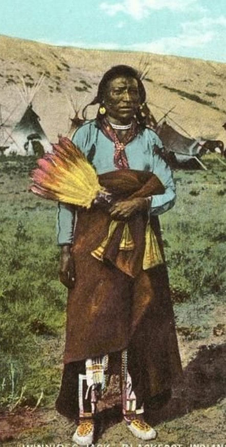


